Sogn og Fjordane was, up to 1 January 2020, a county in western Norway, when it was merged to become part of Vestland county. Bordering previous counties Møre og Romsdal, Oppland, Buskerud, and Hordaland, the county administration was in the village of Hermansverk in Leikanger municipality. The largest town in the county was Førde.
Høyanger is a municipality in Vestland county, Norway. It is located in the traditional district of Sogn. The administrative center is the village of Høyanger. Other villages in Høyanger municipality include Austreim, Bjordal, Kyrkjebø, Lavik, Ortnevik, and Vadheim.

Vik is a municipality in Vestland county, Norway. It is located on the southern shore of the Sognefjorden in the traditional district of Sogn. The administrative center of Vik is the village of Vikøyri. Other villages in the municipality include Feios, Fresvik, Nese, and Vangsnes.

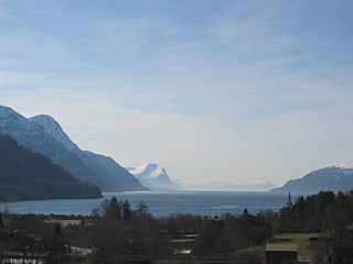
The Sognefjord or Sognefjorden, nicknamed the King of the Fjords, is the largest and deepest fjord in Norway. Located in Vestland county in Western Norway, it stretches 205 kilometres (127 mi) inland from the ocean to the small village of Skjolden in the municipality of Luster.

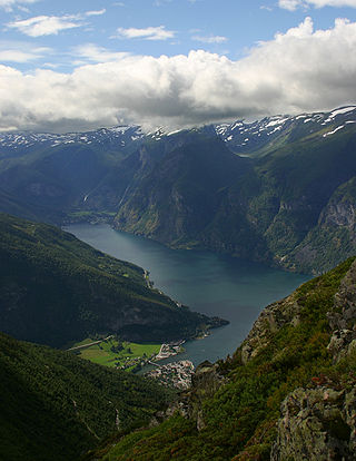
Fresvik is a village in the municipality of Vik in Vestland county, Norway. It is located on the southern shore of the Sognefjorden, just west of where the Aurlandsfjorden joins the Sognefjorden. Fresvik sits about 13 kilometres (8.1 mi) south of Leikanger-Hermansverk, about 20 kilometres (12 mi) east of the municipal center of Vikøyri, and about 15 kilometres (9.3 mi) southeast of the village of Feios. The population (2001) of Fresvik is approximately 275.

Holskardvatnet is a lake in Vik Municipality in Vestland county, Norway. It is located just less than 100 metres (330 ft) north of the border with Modalen Municipality. The lake is 20 kilometres (12 mi) south of the village of Ortnevik in neighboring Høyanger Municipality, about 13 kilometres (8.1 mi) southwest of the village of Arnafjord, and about 28 kilometres (17 mi) southwest of the municipal center of Vikøyri. The 4.81 square kilometres (1.86 sq mi) lake is located at an elevation of 845 metres (2,772 ft) above sea level. There is a dam at the northwest end of the lake.

Fjærland or Mundal is a village in Sogndal Municipality, at the end of the Fjærlandsfjorden, in Vestland county, Norway. The Fjærlandfjorden is a branch going north off the Sognefjorden, the longest fjord in Norway. The village area is located about 31 kilometres (19 mi) northwest of the municipal center of Sogndalsfjøra, along the Norwegian National Road 5. The village and its surrounding area encompass rich farming country, including the nearby areas of Bøyum and Oygard.
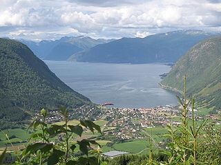
Vikøyri is the administrative center of the municipality of Vik in Vestland county, Norway. The village is located at the mouth of the Vikja river on the south shore of the Sognefjorden, roughly near the midpoint of Norway's longest fjord. The village lies along Norwegian National Road 13 which leads north to the ferry to Balestrand and south to the village of Vossevangen. The 1.37-square-kilometre (340-acre) village has a population (2019) of 1,245 and a population density of 909 inhabitants per square kilometre (2,350/sq mi).
Storfjorden or Storfjord is a 110-kilometre (68 mi) long fjord in the Sunnmøre region of Møre og Romsdal county, Norway. It stretches from the village of Hareid in the west to the villages of Tafjord and Geiranger in the east. The Storfjorden system branches off into several smaller fjords including the famous Geirangerfjord and Tafjorden. At the village of Stranda, the main fjord branches off into the Sunnylvsfjorden-Geirangerfjorden to the west and the Norddalsfjorden-Tafjorden to the east.
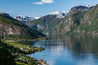
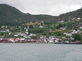
Vangsnes is a village located in the municipality of Vik in Vestland county, Norway. It's located on a relatively flat and fertile peninsula that juts out on the south side of the Sognefjorden, roughly at the midpoint of the fjord which is Norway's longest. The village of Balestrand lies about 7 kilometres (4.3 mi) to the northwest and the villages of Leikanger-Hermansverk lie about 11 kilometres (6.8 mi) straight east. Vangsnes Church is located in the village.
Aurlandsfjord is a fjord in Vestland county, Norway. The fjord flows through the municipalities of Aurland, Vik, and Lærdal. The 29-kilometre (18 mi) long fjord is a branch off of the main Sognefjorden, Norway's longest fjord. The fjord is deep and narrow, reaching a depth of about 962 metres (3,156 ft) below sea level, and its width is generally less than 2 kilometres (1.2 mi) wide. About 11 kilometers (6.8 mi) south of the mouth of the fjord, the Nærøyfjord branches off from it to the west. The village of Flåm sits at the innermost part of the Aurlandsfjord; other villages along the fjord are Aurlandsvangen and Undredal. Most of the fjord is surrounded by up to 1,800-metre (5,900 ft) tall, steep mountains with little habitation along the fjord except for in a few small valleys.

Balestrand is a village in Sogndal Municipality in Vestland county, Norway. The village is located on the northern shore of the Sognefjorden, at the mouth of the small Esefjorden. It sits about 20 kilometres (12 mi) west of the village area of Leikanger-Hermansverk and about 7 kilometres (4.3 mi) northwest of the village of Vangsnes. The small village of Tjugum lies less than 700 metres (2,300 ft) north of Balestrand, across the Esefjorden. The local Tjugum Church is located there, serving the people of the village of Balestrand.

Ytre Sula is an island in Solund Municipality in Vestland county, Norway. The island lies along the Sognesjøen, just west of the mouth of the large Sognefjorden. The 34.7-square-kilometre (13.4 sq mi) island is part of a large island group. It is the westernmost of the three main islands in Solund. The island of Steinsundøyna lies just east of Ytre Sula. There are no road connections to the rest of Norway. To get to the mainland, one must take a ferry connection from Ytre Sula to the smaller island of Rånøyna, cross that island and cross a small bridge to Steinsundøyna, take a bridge from Steinsundøyna to Sula, and then another ferry from Sula to Rutledal in Gulen municipality on the mainland.

Brekke is a village in the northeastern part of Gulen Municipality in Vestland county, Norway. The village of Brekke has a population (2001) of 299 people.
Bjordal is a village in Høyanger Municipality in Vestland county, Norway. The village is located along the Fuglsetfjorden, an arm that branches off the main Sognefjorden to the north. The village sits about 20 kilometres (12 mi) west of the village of Ortnevik and about 10 kilometres (6.2 mi) south of the village of Kyrkjebø, located on the north side of the fjord. Norwegian County Road 92 runs through Bjordal, connecting it to Ortnevik to the northeast and to the village of Matre in Masfjorden municipality to the southwest.
Ortnevik is a village in Høyanger Municipality in Vestland county, Norway. The village is located on the south side of the Sognefjorden. The village is fairly isolated since there is only one road leading to it. Norwegian County Road 92 (Fv92) comes to Ortnevik from the west. The village of Bjordal lies about 20 kilometres (12 mi) to the west along Fv92. There is also a regular car ferry connection which goes from Ortnevik to the north side of the fjord. The ferry stops at Ortnevik, Måren, and Austreim, and a couple time each day it continues from Austreim to the village of Høyanger.
Bjordal Church is a parish church of the Church of Norway in Høyanger Municipality in Vestland county, Norway. It is located in the village of Bjordal. It is one of the two churches for the Bjordal og Ortnevik parish which is part of the Sunnfjord prosti (deanery) in the Diocese of Bjørgvin. The white, wooden church was built in a long church design in 1906 using plans drawn up byusing plans drawn up by the architect Victor Nordan, the son of the famous Norwegian church architect Jacob Wilhelm Nordan. The church seats about 160 people.

Feios is a village in Vik Municipality in Vestland county, Norway. The village is located on the southern shore of the Sognefjorden, about 8 kilometres (5.0 mi) southeast of the village of Vangsnes and about 17 kilometres (11 mi) northwest of the village of Fresvik. The village lies in a small, narrow valley, surrounded by large mountains, with the river Feioselvi running through the center of the valley. Feios Church is located in the village.

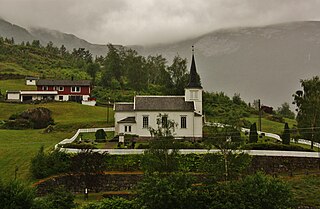
Arnafjord Church is a parish church of the Church of Norway in Vik Municipality in Vestland county, Norway. It is located in the village of Nese, along the Arnafjorden. It is the church for the Arnafjord parish which is part of the Sogn prosti (deanery) in the Diocese of Bjørgvin. The white, wooden church was built in a long church design in 1880. The master builder John Gjertsen from Sogndal made the designs, while builder Anders Korsvold was responsible for the construction. The church seats about 180 people.
Solvorn is a village in Luster Municipality in Vestland county, Norway. The village is located on the western shore of the Lustrafjorden, the innermost part of the Sognefjorden. The village sits directly across the fjord from the village of Ornes, where the famous 12th-century Urnes Stave Church is located. The village of Hafslo lies about 4 kilometres (2.5 mi) to the northwest.

