Erlenbach (help·info) is a municipality in the district of Meilen in the canton of Zürich in Switzerland.

A volcanic plug, also called a volcanic neck or lava neck, is a volcanic object created when magma hardens within a vent on an active volcano. When present, a plug can cause an extreme build-up of pressure if rising volatile-charged magma is trapped beneath it, and this can sometimes lead to an explosive eruption. Glacial erosion can lead to exposure of the plug on one side, while a long slope of material remains on the opposite side. Such landforms are called crag and tail. If a plug is preserved, erosion may remove the surrounding rock while the erosion-resistant plug remains, producing a distinctive upstanding landform.

The Shropshire Hills area, in the English county of Shropshire, is designated as an Area of Outstanding Natural Beauty (AONB). It is located in the south of the county, extending to its border with Wales. Designated in 1958, the area encompasses 802 square kilometres (310 sq mi) of land primarily in south-west Shropshire, taking its name from the upland region of the Shropshire Hills. The A49 road and Welsh Marches Railway Line bisect the area north-south, passing through or near Shrewsbury, Church Stretton, Craven Arms and Ludlow.

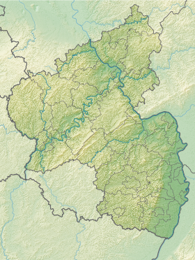
The Palatinate Forest, sometimes also called the Palatine Forest, is a low-mountain region in southwestern Germany, located in the Palatinate in the state of Rhineland-Palatinate. The forest is a designated nature park covering 1,771 km2 and its highest elevation is the Kalmit.
Prideaux Castle is a multivallate Iron Age hillfort situated atop a 133 m (435 ft) high conical hill near the southern boundary of the parish of Luxulyan, Cornwall, England, United Kingdom. It is also sometimes referred to as Prideaux Warren, Prideaux War-Ring, or Prideaux Hillfort. The site is a scheduled monument and so protected from unauthorised works by the Ancient Monuments and Archaeological Areas Act 1979.

Erlenbach bei Dahn is a municipality in Südwestpfalz district, in Rhineland-Palatinate, western Germany.

Drachenfels Castle is a ruined hill castle near the village of Busenberg in the state of Rhineland-Palatinate. It lies within the German half of the Wasgau region, the southern part of the Palatinate Forest.

Berwartstein Castle is a castle in the Wasgau, the southern part of the Palatinate Forest in the state Rhineland-Palatinate in southwestern Germany. It was one of the rock castles that were part of defences of the Palatinate during the Middle Ages. This castle is noted in the publication Works of Preservation of Monuments of Rheinland-Pfalz, which was assembled and edited for the Ministry of Education and Culture. This states that the three prime examples of rock castles in the region are Drachenfels, Altdahn and Berwartstein, castles where the stairs, passages and rooms are carved out of the rock to form part of the accommodation essential to the defence of the castle. Although the Berwartstein appears more complete when compared to the ruins of neighbouring castles, it is only a restoration of the original rock castle. It is the only castle in the Palatinate that was rebuilt and re-inhabited after its demolition.

The Battle of Almaraz was a battle of the Peninsular War which took place on 18–19 May 1812, in which the Anglo-Portuguese Army under Lord Hill destroyed a French pontoon bridge across the River Tagus, in Almaraz, Spain. The bridge was protected by two French garrisons at either end.

Mount Saint Peter, also referred to as Caestert Plateau, is the northern part of a plateau running north to south between the valleys of the river Geer to the west, and the Meuse to the east. It runs from Maastricht in the Netherlands, through Riemst in Belgian Limburg almost to the city of Liège in Belgium, thus defining the topography of this border area between Flanders, Wallonia and the Netherlands. The name of the hill, as well as the nearby village and church of Sint Pieter and the fortress of Sint Pieter, refers to Saint Peter, one of the Twelve Apostles.

The Speyerbach is a left tributary of the Rhine in the Palatinate part of Rhineland-Palatinate. In Speyer, the river split into Gießhübelbach and Woogbach. The Woogbach changes its name to Nonnenbach, then flows into Gießhübelbach shortly before the latter flows into the Rhine.

A rock castle is a type of medieval castle that directly incorporates natural rock outcrops into its defences to such an extent that the rock formations define the structure of the castle. Topographically, rock castles are classified as hill castles.

The Dahner Felsenland, also referred to as the Dahn Rockland, is a landscape in the county of Südwestpfalz in the German federal state of Rhineland-Palatinate. It is located in the middle section of the Wasgau, which in turn forms the southern part of the Palatine Forest and the northern part of the Vosges in France. The Dahner Felsenland has numerous rock formations within the South Palatinate Climbing Area.
The Wasgau is a Franco-German hill range in the German state of Rhineland-Palatinate and the French departments of Bas-Rhin and Moselle. It is formed from the southern part of the Palatine Forest and the northern part of the Vosges mountains, and extends from the River Queich in the north over the French border to the Col de Saverne in the south.

The Palatine Ways of St. James are those sections of the Way of St. James in the Palatinate region of Germany and part of the historic pilgrimage route to the northwest Spanish town of Santiago de Compostela. It was there that, according to Christian tradition, the Apostle Saint James the Greater was buried.

Hans von Trotha was a German knight and marshal of the prince-elector of the Palatinate. He also bore the French honorary title of a Chevalier d’Or. In 1480, the elector enfeoffed him with the two castles of Berwartstein and Grafendahn which lay in the South Palatine part of the Wasgau region within the Palatinate Forest. In local folklore he is known as Hans Trapp or, more rarely, Hans Trott.
The Erlenbach is a stream, over 9 km long, in the South Palatine Wasgau region of the German state of Rhineland-Palatinate. It is a left tributary of the Lauter which, here in its upper reaches is still called the Wieslauter.

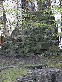
Little France is the ruin of a hillside fort in the German region of Dahner Felsenland. It lies above the village of Erlenbach bei Dahn in the county of Südwestpfalz in the state of Rhineland-Palatinate.

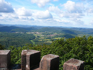
The Heidenberg is a 420-metre-high hill in the southeastern Wasgau, the region that covers the southern part of the Palatinate Forest in Germany and the northern Vosges in France. The Heidenberg's north flank is in the parish of Busenberg, its south flank in the parish of Erlenbach bei Dahn.
Lancaster Roman Fort, also known as Wery Wall, Galacum or Calunium, is the modern name given to ruined former Roman fort atop Castle Hill in Lancaster in North West England. The first castra was founded c. 80 AD within the Roman province of Britannia.