
The geography of France consists of a terrain that is mostly flat plains or gently rolling hills in the north and west and mountainous in the south and the east. Metropolitan France has a total size of 551,695 km2 (213,011 sq mi). It is the third largest country in Europe after Russia and Ukraine.
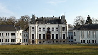
Brakel is a municipality in the Belgian province of East Flanders in the Denderstreek and the Flemish Ardennes. The name is derived from a Carolingian villa Braglo first mentioned in 866 and located in the center of Opbrakel. Since 1970, the municipality has comprised the villages of Nederbrakel, Opbrakel, Michelbeke, Elst, Zegelsem. In 1977 Everbeek, Parike and part of Sint-Maria-Oudenhove were added. On January 1, 2006, Brakel had a population of 13,726. The area is 56.46 km² which gives a population density of 243 per km². The mayor is Stefaan De Vleeschouwer.
Höxter is a Kreis (district) in the east of North Rhine-Westphalia, Germany. Neighboring districts are Holzminden, Northeim, Kassel, Waldeck-Frankenberg, Hochsauerland, Paderborn, and Lippe.
Paderborn is a Kreis (district) in the east of North Rhine-Westphalia, Germany. Neighboring districts are Gütersloh, Lippe, Höxter, Hochsauerland, and Soest.

The Rhön Mountains are a group of low mountains in central Germany, located around the border area where the states of Hesse, Bavaria and Thuringia come together. These mountains, which are at the extreme southeast end of the East Hesse Highlands, are partly a result of ancient volcanic activity. They are separated from the Vogelsberg Mountains by the river Fulda and its valley. The highest mountain in the Rhön is the Wasserkuppe which is in Hesse. The Rhön Mountains are a popular tourist destination and walking area.
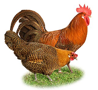
The Braekel or Brakel is a traditional Belgian breed of chicken. It is thought to have originated in the area of Brakel, in the Flemish province of East Flanders, for which it is named. There is a bantam version of the Braekel. The Campine of the United Kingdom derives from it.

Voorne-Putten is an island between the North Sea, the Brielse meer and the rivers Oude Maas, Spui and Haringvliet in the province of South Holland in the Netherlands. Voorne-Putten consists of the two former islands Voorne and Putten. It used to be separated by the river Bernisse which silted up and made the two islands one. It has 160,000 inhabitants (2008). Recently the riverbed has been dredged, and the two islands have been reformed.

Gau is a Germanic term for a region within a country, often a former or actual province. It was used in the Middle Ages, when it can be seen as roughly corresponding to an English shire. The administrative use of the term was revived as a subdivision during the period of Nazi Germany in 1933–1945. It still appears today in regional names, such as the Rheingau or Allgäu.

Valdres is a traditional district in central, southern Norway, situated between Gudbrandsdalen and Hallingdal. The region around Valdres consists of the six municipalities of Nord-Aurdal, Sør-Aurdal, Øystre Slidre, Vestre Slidre, Vang and Etnedal. Valdres has about 18,000 inhabitants and is known for its excellent trout fishing and "beautiful" dialect. Its main road is E16 and Fylkesveg 51.

Cacheu is a town in northwestern Guinea-Bissau, lying on the Cacheu River. Its population was estimated to be 9,849 as of 2008.
Parkland is a region in the Canadian province of Manitoba. It is located in the western part of the province, between Lake Manitoba and Lake Winnipegosis on the east and the Manitoba – Saskatchewan border on the west. The region comprises three of Statistics Canada's census divisions of Canada. Manitoba Census Divisions No. 16, No. 17, and No. 20, which together have a land area of 28,209.93 km2 and a population of 42,088 are contained within the region. The largest population centre is the city of Dauphin, and the second largest is the town of Swan River. Riding Mountain National Park, Duck Mountain Provincial Park and Asessippi Provincial Park are located in the region. Manitoba's highest point, Baldy Mountain, is also located here.The Parkland region often also includes the Yorkton/Melville Region in Saskatchewan.

The Vinschgau, Vintschgau or Vinschgau Valley is the upper part of the Adige or Etsch river valley, in the western part of the province of South Tyrol, Italy.
The Königssondergau was a Frankish gau (district) which existed in the area north of the confluence of the Rhine and Main rivers in Germany, from Frankish times until the end of the 12th century. Often mistakenly equated with the Rheingau, the Gau was based around the former Roman administrative district of Civitas Mattiacorum. The name Kunigessuntera is documented the first time in 819. A main court (fiscus) with senior officials were present in Wiesbaden; sub-courts existed in Biebrich and Mosbach.

Trần Văn Thời is a rural district (huyện) of Cà Mau Province in the Mekong Delta region of Vietnam. As of 2003, the district had a population of 191,718. The area spans 700 km². The district capital lies at Trần Văn Thời.

The Gäu Plateaus form the largest natural region in the German state of Baden-Württemberg. Not surprisingly, the individual geographical units of this large region show considerable variations in climate and soil types. A common feature of the region, however, is its landscape of flat-topped hills of Muschelkalk, gently rolling tracts of loess and plateaus in which the layers of Muschelkalk have been covered by sediments of Gipskeuper and Lettenkeuper.
The Oberwälder Land is a natural region in the extreme east of the German state of North Rhine-Westphalia with small elements parts in Hesse and Lower Saxony. It consists of Muschelkalk upland, heavily dissected by the Nethe and its tributaries, between the Eggegebirge to the west, the Lippe Uplands to the north, the Weser Valley around Holzminden to the east, the West Hesse Depression to the southeast and the Warburg Börde to the south. This natural region is part of the upper Weser Uplands and hence the German Central Uplands.

The Ambergau is a historic landscape and natural region unit in the Innerste Uplands in southern Lower Saxony, Germany. It is a basin, about 10 x 10 kilometres across, with 18 settlements, the centre and capital of which since the 13th century is the town of Bockenem. The basin, with its fertile agricultural fields, is surrounded by the wooded ridges of Heber, the Harplage, the Weinberg and the Hainberg. The Gau is a cultural landscape that was formed as early as the 8th century.

The Teutoburg Forest / Egge Hills Nature Park is a nature park founded in 1965 in the northeast of the German state of North Rhine-Westphalia. After being expanded in 2008, the nature park is now the largest in Germany, covering an area of 2,700 km2. The park comprise the southern Teutoburg Forest and Egge Hills.
The Leberg is a hill and uphill street in Elst, part of the municipality of Brakel, in the Belgian province of East Flanders. Its top is at 99 m altitude, making it one of the highest hills of the Zwalm region, just north of the Flemish Ardennes. The road has an asphalt surface and links the valley town of Elst to the hilltop town of Zegelsem.