
Rieselfeld is a city quarter (Stadtteil) in Freiburg im Breisgau. It is located in the western part of the city and borders the nature reserve Freiburger Rieselfeld in the west, right next to a little zoo called Tiergehege Mundenhof, Opfinger Straße in the south and Besançonallee in the east. The industrial area Haid is part of the Sankt Georgen district and is located to the south of Rieselfeld, while the district Weingarten is situated to the east of Rieselfeld.

Herdern is a quarter (Stadtteil) of Freiburg im Breisgau in Baden-Württemberg, Germany.

Freiburg Castle is a vanished castle. When it existed it was usually called the Burghaldenschloss.

The Freiburg im Breisgau tramway network is a network of tramways that forms part of the public transport system in Freiburg im Breisgau, a city in the federal state of Baden-Württemberg, Germany. Established in 1901, the network has been operated since its foundation by the company now known as Freiburger Verkehrs, and powered by electricity. The tramway network currently has five lines. The expansion of the tram network since 1980 has served as an example of the "renaissance of the trams" in Germany. As of 2023, 73 trams were available for regular use: 2 of these were high-floored, 36 partial and 35 low-floored. Almost the entirety of the network is located within Freiburg's urban area; only a few metres of the balloon loop at Gundelfinger Straße are located outside the boundary of Gundelfingen to the north of Freiburg. In total, the trams serve 20 out of the 28 districts in Freiburg.

The Kaiser-Joseph-Straße in Freiburg im Breisgau is a shopping street of about 900 meters, which runs through the center of Freiburg's historic downtown from north to south. It is one of the most expensive locations in Germany.

Günterstal Abbey, earlier also Güntersthal Abbey, was a Cistercian nunnery that existed from 1221 to 1806 located in Günterstal, which today is a district in Freiburg im Breisgau, Germany.

Freiburg im Breisgau's parks, green spaces, recreational facilities, playgrounds, roadside greeneries and the Mundenhof add up to an area of 397 ha (3.97 km2), which corresponds to 18.05 m2 of green space per Freiburg citizen. On average, major cities in Baden-Württemberg have 22.66 m2 green space/citizen. However, there is an area of 2600 ha (26 km2) of forest in the close proximity of Freiburg as well as additional recreational area like the Rieselfeld district. The majority of the green spaces came into existence from the 1960s on.

The Whale House is a late Gothic bourgeois house in the old town of Freiburg im Breisgau, Baden-Württemberg, Germany and is under conservation. The building is currently used by the Sparkasse Freiburg-Nördlicher Breisgau bank. It is part of a complex which, in the past, was made up of 17 separate buildings. The front wall of the house opens onto the Franziskanerstraße, whilst the rear is on the Gauchstraße, near Kartoffelmarkt square.

The History of Freiburg im Breisgau can be traced back 900 years. Around 100 years after Freiburg was founded in 1120 by the Zähringer, until their family died out. The unloved Counts of Freiburg followed as the town lords, who then sold it onto the Habsburgers. At the start of the 19th century, the (catholic) Austrian ownership of the town ended, when Napoleon, after having invaded the town, decreed the town and Breisgau to be a part of the Grand Duchy of Baden in 1806. Until 1918, Freiburg belonged to the Grand Duchy, until 1933 to the Weimar Republic and Gau Baden in Nazi Germany. After the Second World War, the town was the state capital of (South) Baden from 1949 until 1952. Today, Freiburg is the fourth-largest city in Baden-Württemberg.

Weingarten is a municipal district of Freiburg im Breisgau. In the north, it is separated by the river Dreisam from the district Betzenhausen, in the east beyond the rail tracks lies Haslach and in the south, separated by the Opfinger Road, the district Haslach-Haid. In the west, the new district Rieselfeld borders Weingarten.

The Colombischlössle is a manor house in the city centre of Freiburg im Breisgau where the eponymous archaeological museum is situated.
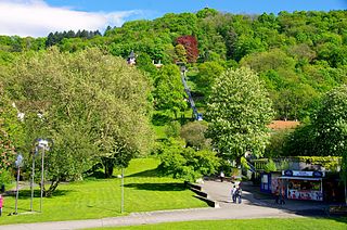
The Stadtgarten of Freiburg is a 2.6 ha park within the Neuburg district. It has an old tree grove and a large rose garden, and lies between the Leopoldring, Jackob Burckhardt, Ludwig and Mozart streets near Freiburg's city centre. It is connected to Karlsplatz via the Karlssteg footbridge, which is made from pre-stressed concrete. Since 2008 the Schlossberg Tram, an inclined elevator, leads up to Schlossberg. It replaced the Schlossberg Cable Car built in 1968.
Mooswald is a district in the western part of Freiburg im Breisgau, Germany, which consists of the two districts Mooswald West (521) and Mooswald East (522). Its population is 9,223 (2020). In the North East, Mooswald borders the district of Brühl, with its airfield, the university campus of the technical faculty and the exhibition centre. Mooswald further borders the district of Landwasser in the North West, the district of Stühlinger in the East and the district of Betzenhausen with the Seepark in the South West. Mooswald is separated from Brühl by the Breisgau S-Bahn, from Landwasser by the Westrandstraße (Paduaallee/Mooswaldallee) and from Stühlinger by the railway tracks of the freight railway.
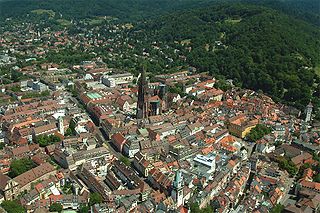
The Old City of Freiburg is part of the city and business centres of Freiburg im Breisgau and is the core of the original city. It is divided into the two districts 111 Altstadt-Mitte and 112 Altstadt-Ring. The Altstadt-Mitte district was the city's build-up area at the time of its foundation and therefore formed the old city. The district Altstadt-Ring is connected westwards to the railway line and south to the Dreisam.

The Platz der Alten Synagoge is a square in Freiburg, Germany. With a size of 130 square metres, it is the second largest square in the city after Minster Square. The square is named after the old synagogue, which was destroyed during the Kristallnacht in 1938. The synagogue had been built in 1869/1870 to the southwest of today's location of the square.

Wiwilíbrücke is a bridge of the German city Freiburg im Breisgau which is also called Blaue Brücke because of its paint and it had formerly been called Stühlingerbücke before the new Stühlingerbücke was built for the tramway. The bridge connects the city’s district Stühlinger to the old town as it links the church square of Herz-Jesu-Kirche to Konrad-Adenauer-Platz in spanning the railway tracks of Freiburg Hauptbahnhof. Today, Wiwilíbrücke is a listed building and is used by up to 10,000 cyclists per day.

The old cemetery in Neuburg, a district of Freiburg im Breisgau, Germany, covers an area of 2.65 hectares. Situated on park-like grounds, the old cemetery is one of Germany's oldest cemeteries that have been abandoned and preserved as a whole. Located close to the Ludwigskirche, it is often mistaken to be part of the neighboring district Herdern. Providing tombs to an estimate of 1200 people, half of them are worthy of preservation. The booster club takes care of maintenance. The old cemetery falls under preservation order of cultural and natural monument. Moreover, it can be seen as evidence for death cult, town history and stylistic area of the 17th and 18th century. Serving not only as a place for individual and artistic tombstones of middle class people. Furthermore, the old cemetery grants an insight into the consciousness of faith during the baroque period until the time of neo-classicism.

Waldsee is an eastern district of Freiburg im Breisgau, Baden-Württemberg, Germany, with a population of around 5,400 inhabitants. It is named after the local recreational area of the same name. It lies between the districts Wiehre and Oberau in the west and Littenweiler and Ebnet in the east. In the north and the south, it is bordered by the Dreisam Valley mountains. The Dreisam flows through Waldsee from the east to the west and forms the northern boundary of the residential development area here.

The siege of Freiburg took place between 9 and 16 November 1677, as part of the Franco-Dutch War, and ended with the conquest of the city by the French.

The village Günterstal is the southernmost district of Freiburg im Breisgau. It is located in the so-called Bohrer-Tal area at the foot of the 1284 metre-high Schauinsland in the Günterstal district of the Black Forest. Due to this, Freiburg prides itself on being Germany's highest city. Günterstal has more than 2,000 inhabitants and is separated from Freiburg by a two-kilometre-wide meadow, the "Wonnhaldewiesen". The village was incorporated into Freiburg in 1890. The southern neighbouring municipality is Horben.


