
Woodbury is a town in Litchfield County, Connecticut, United States. The population was 9,723 at the 2020 census. The town center, comprising the adjacent villages of Woodbury and North Woodbury, is designated by the U.S. Census Bureau as the Woodbury Center census-designated place (CDP). Woodbury was founded in 1673.

Woodbury Township is a township in Blair County, Pennsylvania, United States. It is part of the Altoona, PA Metropolitan Statistical Area. The population was 1,443 at the 2020 census.

The Connecticut panhandle is the southwestern appendage of Connecticut, where it abuts New York State. It is contained entirely in Fairfield County and includes all of Greenwich, Stamford, New Canaan, and Darien, as well as parts of Norwalk and Wilton. It has some of the most expensive residential real estate in the United States.

Area codes 203 and 475 are telephone area codes in the North American Numbering Plan (NANP) for the southwestern part of the U.S. state of Connecticut. The numbering plan area (NPA) is mostly coextensive with the Connecticut portion of the New York metropolitan area, and comprises most of Fairfield County, all of New Haven County, and a small portion of Litchfield County.

Byram is a neighborhood/section and census-designated place (CDP) in the town of Greenwich in Fairfield County, Connecticut, United States. It had a population of 4,146 at the 2010 census, and a census-estimated population of 4,216 in 2018. An endcap of Connecticut's Gold Coast, Byram is the southernmost point in the town of Greenwich and the U.S. state of Connecticut. It is separated from Port Chester, Westchester County, New York, by the Byram River. Byram was once known as East Port Chester.
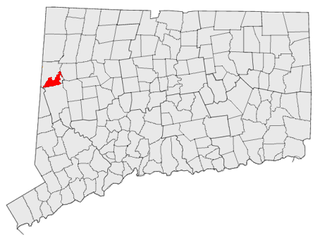
South Kent is a village located in Litchfield County, Connecticut, United States, alongside the border with New York, and within and part of Kent, Connecticut. South Kent has its own Post Office whose ZIP code is 06785. South Kent is also home to South Kent School, a private prep school.
The Stewart B. McKinney National Wildlife Refuge is a 950-acre (384.5 ha) National Wildlife Refuge in ten units across the U.S. state of Connecticut. Located in the Atlantic Flyway, the refuge spans 70 miles (110 km) of Connecticut coastline and provides important resting, feeding, and nesting habitat for many species of wading birds, shorebirds, songbirds and terns, including the endangered roseate tern. Adjacent waters serve as wintering habitat for brant, scoters, American black duck, and other waterfowl. Overall, the refuge encompasses over 900 acres (364.2 ha) of barrier beach, intertidal wetland and fragile island habitats.

Connecticut's 5th congressional district is a congressional district in the U.S. state of Connecticut. Located in the western part of the state and spanning across parts of Fairfield, Litchfield, New Haven, and Hartford Counties, the district runs from Meriden and New Britain in central Connecticut, westward to Danbury and the surrounding Housatonic Valley, encompassing the Farmington Valley, Upper Naugatuck River Valley, and the Litchfield Hills. The district also includes most of Waterbury.

Connecticut's 1st congressional district is a congressional district in the U.S. state of Connecticut. Located in the north-central part of the state, the district is anchored by the state capital of Hartford. It encompasses much of central Connecticut and includes towns within Hartford, Litchfield, and Middlesex counties.

Botsford is a village of Newtown in Fairfield County, Connecticut, United States. The town of Newtown has one political body, but consists of multiple geographic subdivisions. It currently contains a fire department and post office. CT 25 runs along the western part of the village. Botsford was listed as a census-designated place prior to the 2020 census.

The Ten Mile River is a 15.4-mile-long (24.8 km) river that flows through Dutchess County, New York, into westernmost Connecticut. The river is formed in the town of Amenia, New York, at the confluence of Webatuck Creek and Wassaic Creek. The Ten Mile River runs south through the town of Dover, New York before turning east and crossing into Connecticut, where it forms the boundary between the towns of Kent and Sherman for one-half mile before flowing into the Housatonic River. This is a popular whitewater paddling destination with mostly quickwater and a few whitewater areas reaching up to Class III.
Woodbury Ski Area was a ski area located in Woodbury, Connecticut. This small ski area was in northwestern Connecticut, about 2 hours from New York City. The skiing and snow tubing operations were serviced by a chairlift and multiple surface lifts. Local residents referred to it as "Rod's" after its owner, Olympic skier Rod Taylor.

The Mill River is a 16.3-mile (26.2 km) river in the town of Fairfield, Connecticut. It flows into Long Island Sound at Southport harbor.

The Pomperaug River is a 13.4-mile-long (21.6 km) river in the US state of Connecticut. The two main tributaries to the Pomperaug are the Nonnewaug River and the Weekeepeemee River; their confluence forms the Pomperaug and Woodbury developed here. The river flows through Woodbury and the Town of Southbury, where it empties into the Housatonic River at Lake Zoar. The name of the river is from a local Native American language, likely Paugussset.

The Aspetuck River is a 17.0-mile-long (27.4 km) river in the U.S. state of Connecticut. The river rises in the hills located in Huntington State Park in Bethel, with a watershed of approximately 430 acres (170 ha). The river flows generally southerly through Redding, Connecticut, to the Aspetuck Reservoir, the Hemlock Reservoir in Easton and Fairfield and finally into the Saugatuck River in Westport, Connecticut and then into the Long Island Sound. It flows through the village of Aspetuck at an average depth of 2.5 feet (0.76 m). The word Aspetuck can be translated as "river originating at the high place" in an Algonquian language.

The Silvermine River is an 8.4-mile-long (13.5 km) river that flows through the towns of Norwalk, Wilton and New Canaan, Connecticut. It is spanned by the 1899 Perry Avenue Bridge in the Silvermine neighborhood, and by the Silvermine River Bridge that carries the Merritt Parkway. It is a tributary of the Norwalk River which it joins at the north end of Deering Pond.

The Pequonnock River is a 16.7-mile-long (26.9 km) waterway in eastern Fairfield County, Connecticut. Its watershed is located in five communities, with the majority of it located within Monroe, Trumbull, and Bridgeport. The river has a penchant for flooding, particularly in spring since the removal of a retention dam in Trumbull in the 1950s. There seems to be a sharp difference of opinion among historians as to just what the Indian word Pequonnock signifies. Some insist it meant cleared field or open ground; others are sure it meant broken ground; while a third group is certain it meant place of slaughter or place of destruction.
Tryon's Raid occurred in July 1779, during the American Revolutionary War, in which 2700 men, led by British Major General William Tryon, raided the Connecticut ports of New Haven, Fairfield, and Norwalk. They destroyed military and public stores, supply houses, and ships as well as private homes, churches, and other public buildings. The raids were ineffectually resisted by militia forces.

The Webb Mountain Discovery Zone is a 170 acre park and outdoor learning center in Monroe, Connecticut, United States. The adjacent 135 acre Webb Mountain Park connects up to a 13.5 mile trail network.

Treetops is the former estate of torch singer and actress Libby Holman. It forms the southernmost part of Mianus River Park and is overseen by the Connecticut Department of Energy and Environmental Protection as the Mianus River State Park.