
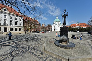
New Town Market Place (Polish : Rynek Nowego Miasta) is the main square of the New Town of Warsaw, Poland.
New Town Market Place (Polish : Rynek Nowego Miasta) is the main square of the New Town of Warsaw, Poland.
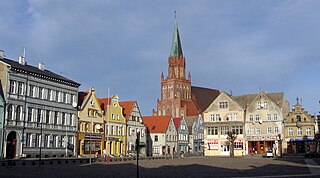
It was formed before 1408, as the main square of the Warsaw New Town. It initially had a rectangular shape, with an area of 140 x 120 meters. In the 15th century, a wooden town hall was built in the center of the square and residential buildings were also constructed. In 1544 the square was damaged by fire, and the town hall was reconstructed in brick. The rest of the buildings remained wooden. [1]


In 1656 the square was burned down by Swedes, during the Deluge. The reconstruction was slow, and the town hall was rebuilt again in 1680. In 1688 the Baroque Saint Kazimierz Church was built by Dutch architect Tylman van Gameren. In the second half of the 18th century, wooden residential buildings were replaced by bricked tenement houses. In 1785, the town hall was partially reconstructed and several shops were added to it. In 1818 the town hall was torn down, and the square gained its market character, which continued until 1878. Then, the buildings on the square were expanded and reconstructed to house growing number of craftsmen and workers. In 1932 a statue of Saint Klemens Hofbauer was placed in the square. [1]
In World War II, during the Warsaw Uprising of 1944, the square was completely destroyed, 80% of houses were completely demolished, including the church. After the war, the square was reconstructed in the 18th-century style. The reconstruction lasted until 1955. [1]
A 19th century well is located in the southern part of the square. The image of a girl with a unicorn, old symbol of the New Town, can be found on the top of its eclectic cast-iron pump. [1]

Zamość is a historical city in southeastern Poland. It is situated in the southern part of Lublin Voivodeship, about 90 km (56 mi) from Lublin, 247 km (153 mi) from Warsaw. In 2021, the population of Zamość was 62,021.

Nowy Świat, known in English as New World Street, is one of the main historic thoroughfares of Warsaw, Poland. It comprises part of the Royal Route that extends from Warsaw's Royal Castle and Old Town, south to King John III Sobieski's 17th-century royal residence at Wilanów.
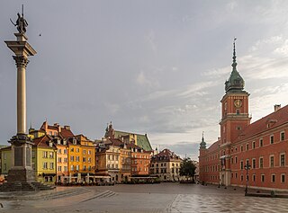
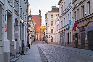
Warsaw Old Town, also known as Old Town, and historically known as Old Warsaw, is a neighbourhood, and an area of the City Information System, in the city of Warsaw, Poland, located within the district of Śródmieście. It is the oldest portion of the city, and contains numerous historic buildings, mostly from 17th and 18th centuries, such as the Royal Castle, city walls, St. John's Cathedral, and the Barbican, the Old Town Market Square and the Warsaw Mermaid Statue. The settlement itself dates back to between the 13th and 14th centuries, and was granted town privileges c. 1300.

The Main Square of the Old Town of Kraków, Lesser Poland, is the principal urban space located at the center of the city. It dates back to the 13th century, and at 3.79 ha is sometimes called the largest medieval town square in Europe, but Charles Square in Prague is two times larger.
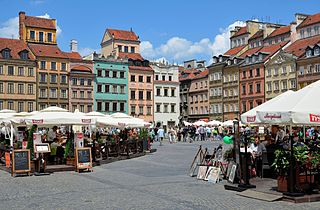
Warsaw's Old Town Market Place is the center and oldest part of the Old Town of Warsaw, Poland. Immediately after the Warsaw Uprising, it was systematically blown up by the German Army. After World War II, the Old Town Market Place was restored to its prewar appearance.

St. Casimir Church is a Roman Catholic church in Warsaw's New Town at Rynek Nowego Miasta 2.
The Kotowski Palace was a 17th-century palace in Warsaw, Poland. It served as the main cloister building for the Benedictine Sisters of Perpetual Adoration.

The architecture of Poland includes modern and historical monuments of architectural and historical importance.
New Town, historically known as New Warsaw, is a neighbourhood, and an area of the City Information System, in the city of Warsaw, Poland, located within the district of Śródmieście.

Poznań Old Town is the centermost neighbourhood of the city of Poznań in western Poland, covering the area of the once walled medieval city of Poznań. It is called Stare Miasto in Polish, although that name may also refer to the wider administrative district of Stare Miasto, which extends to most of the city centre and northern parts of the city.

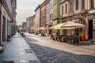
Grodzka Street is a historical street in Old Town of Bydgoszcz, Poland. The street is located in the northern part of the Old Town: it stretches along Brda River waterfront, following an east-west axis. The street starts at the intersection with Bernardyńska street and ends at Tadeusz Malczewski street's crossing. Its length is approximately 430 m. The Grodzka Street was laid out in mid-14th century, when Bydgoszcz became a charter city. Grodzka Street buildings vary greatly one from the other, beginning with the three historic granaries from late 18th century, to the all-glass similar-shape modern mBank in Bydgoszcz, which became an icon of Polish architecture.
Długa Street is the longest street of Old Town district in Bydgoszcz and the most important historically. It stands next to Gdańska Street and Dworcowa Street as one of the most important avenues of downtown Bydgoszcz.

The Voivodeship and Municipal Public Library "Dr. Witold Bełza" in Bydgoszcz is housed in historical buildings located between the Stary Rynek and Długa street, registered on the Kuyavian-Pomeranian Voivodeship Heritage List. It is the oldest (1903) library in activity in the Kuyavian-Pomeranian Voivodeship. Since 2002, it bears the name of Witold Bełza.
Jezuicka Street is a street located in Bydgoszcz, Poland. Many of its buildings are either registered on Kuyavian-Pomeranian Voivodeship heritage list, or part of Bydgoszcz local history.

Farna Street is a street located in Bydgoszcz, Poland. Many of its buildings are either registered on Kuyavian-Pomeranian Voivodeship heritage list, or part of Bydgoszcz local history.

Bydgoszcz Old Market square is an oblong place, situated in the old town district of the city of Bydgoszcz. The City Hall flanks one of its side, and nearby is located St. Martin and St. Nicholas Cathedral.

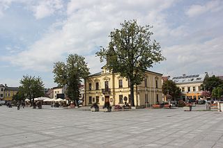
Kościuszko Square is the representative and central square of Białystok, capital of Podlaskie Voivodeship in north-eastern Poland.
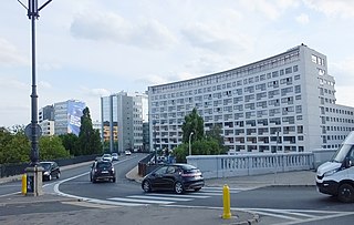
Solec is a neighbourhood along the Vistula river in Warsaw, the capital of Poland. It is situated east of Frascati on the southeastern edge of Downtown and south of the Powiśle suburb. Solec was a self governing settlement and town from 1675 until its incorporation into Warsaw in 1791. The name "Solec" is derived from the Polish word for salt – sól – which was extensively traded and transported through the neighbourhood since the late Middle Ages. However, contemporary Solec is mostly occupied by residential tower blocks and commercial buildings.
The Market Square in Nowy Targ is located in the center of the town. It was laid out for the first time in 1346, when the city was founded. There are 8 streets leading to the Market Square - two to each corner: Szaflarska St and Harcerska St to the south-eastern corner, John III Sobieski St and Tadeusz Kościuszko St to the north-east one, St. Catherine St and Szkolna St to the north-west one, and Kolejowa St and Casimir III the Great St to the south-west one. It has the shape of a rectangle with the dimensions of 138 x 110 m, which gives the area of 1.5 hectares.
Architecture in Trzebiatów is dominated by historical forms from the Middle Ages to the early 20th century. Within the defensive walls, Trzebiatów has preserved over 50% of its historic buildings. The city features architectural elements from the Gothic, Renaissance, Baroque, Neoclassical, and Modernist periods.
52°15′10″N21°0′29″E / 52.25278°N 21.00806°E
| | This Warsaw-related location article is a stub. You can help Wikipedia by expanding it. |