Related Research Articles
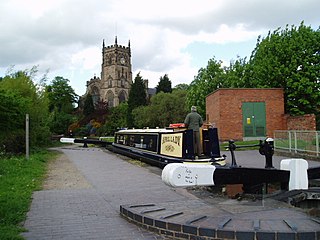
The Staffordshire and Worcestershire Canal is a navigable narrow canal in Staffordshire and Worcestershire in the English Midlands. It is 46 miles (74 km) long, linking the River Severn at Stourport in Worcestershire with the Trent and Mersey Canal at Haywood Junction by Great Haywood.

The A41 is a trunk road between London and Liverpool, England. Now in parts replaced by motorways, it passes through or near Watford, Kings Langley, Hemel Hempstead, Aylesbury, Bicester, Solihull, Birmingham, West Bromwich, Wolverhampton, Newport, Whitchurch, Chester and Ellesmere Port.

The Stour(, rhymes with "flour") is a river flowing through the counties of Worcestershire, the West Midlands and Staffordshire in the West Midlands region of England. The Stour is a major tributary of the River Severn, and is about 25 miles (40 km) in length. It has played a considerable part in the economic history of the region.
Compton is a suburb of Wolverhampton, West Midlands, England. It is located to the west of Wolverhampton city centre on the A454, within the Tettenhall Wightwick ward.
Wightwick is a part of Tettenhall Wightwick ward in Wolverhampton, West Midlands, England. It is named after an ancient local family the "de Wightwicks". It is on the western fringe of Wolverhampton and borders the rural South Staffordshire area that includes neighbourhoods such as Perton.
Tettenhall is a historic village within the City of Wolverhampton, England. Tettenhall became part of Wolverhampton in 1966, along with Bilston, Wednesfield and parts of Willenhall, Coseley and Sedgley.
Oxley is a suburb of Wolverhampton, West Midlands, and a ward of the City of Wolverhampton Council. Its area code is WV10. It is situated in the north of the city, bordering South Staffordshire and the Bushbury North, Bushbury South and Low Hill, St Peter's and Tettenhall Regis wards. It forms part of the Wolverhampton North East constituency.

Wombourne is a village and civil parish located in the district of South Staffordshire, in the county of Staffordshire, England. It is 4 miles (6 km) south-west of Wolverhampton and on the border with the West Midlands County.
Castlecroft is a suburb of Wolverhampton, West Midlands, located on the edge of the city, WSW of the city centre. It is situated where the Merry Hill, and Tettenhall Wightwick wards meet, and also borders South Staffordshire.
Park, or Park Ward, is a ward of Wolverhampton City Council, West Midlands. It is located to the west of the city centre, and covers parts of the suburbs Bradmore, Compton, Finchfield, Merridale, Newbridge and Whitmore Reans. It borders the St Peter's, Graiseley, Merry Hill, Tettenhall Wightwick and Tettenhall Regis wards. It forms part of the Wolverhampton South West constituency.
Tettenhall Wightwick is a ward of Wolverhampton City Council, West Midlands. The population of this ward taken at the 2011 census was 10,872.
Tettenhall Regis is a ward of Wolverhampton City Council, West Midlands. The population of this ward at the 2011 census was 11,911.
Aldersley is a suburb of Wolverhampton, West Midlands, England. It is north-west of Wolverhampton city centre, within the Tettenhall Regis ward. Aldersley is a relatively modern part of Wolverhampton, with most of the housing stock – both private and council – dating from after World War II.
Claregate is a suburb of Wolverhampton, West Midlands, England. It is north west of Wolverhampton city centre, within the Tettenhall Regis ward.
Pendeford is a suburb of Wolverhampton, West Midlands, England. Historically part of Staffordshire, it is situated north-north-west of the city centre, within the Oxley ward of the City of Wolverhampton Council. At the 2011 Census, the population of Pendeford was 5,826, increasing from 4,356 at the 2001 Census.
Smestow Valley Leisure Ride is an approximately 10 miles (16 km) long cycle path linking Aldersley Leisure Village in Aldersley, Wolverhampton following the route of the disused Wombourne Branchline to the disused Wombourne railway station. From Wombourne station, the route follows the Staffordshire and Worcestershire Canal back to Aldersley Leisure Village forming a circular route. Refreshments are provided at both locations. The route passes near Wightwick Manor, Bratch Locks and the Old Station Tettenhall.

Trysull is a rural village in the county of Staffordshire, England approximately five miles south-west of Wolverhampton. With the adjacent village of Seisdon, it forms the civil parish of Trysull and Seisdon, within the South Staffordshire non-metropolitan district. Until 1974 it formed part of Seisdon Rural District. The 2011 census recorded a usually resident population for the parish of Trysull & Seisdon of 1,150 persons in 455 households.
Smestow Academy, also known as simply Smestow is a coeducational secondary school and sixth form located in the Castlecroft area of Wolverhampton, England.
The Smestow Brook, sometimes called the River Smestow, is a small river that plays an important part in the drainage of Wolverhampton, South Staffordshire, and parts of Dudley in the United Kingdom, and has contributed to the industrial development of the Black Country. It is the most important tributary of the River Stour, Worcestershire and part of the River Severn catchment.

The Wom Brook is a stream in South Staffordshire, England. It flows through the large village of Wombourne, and has played an important part in its industrial history. It is an important tributary of the River Smestow and part of the Severn catchment.
References
- ↑ Wrottesley, George (1884). Collections for a History of Staffordshire Series 1 (Volume V). Harrison and Sons.
- ↑ Staffordshire Past Track allows comparison of various maps
- ↑ Collections for a History of Staffordshire Series 1 (Volume X). 1889.
- ↑ "Archived copy". Archived from the original on 8 July 2007. Retrieved 21 May 2007.
{{cite web}}: CS1 maint: archived copy as title (link)