
Fiordland is a geographical region of New Zealand in the south-western corner of the South Island, comprising the westernmost third of Southland. Most of Fiordland is dominated by the steep sides of the snow-capped Southern Alps, deep lakes, and its steep, glacier-carved and now ocean-flooded western valleys. The name "Fiordland" comes from a variant spelling of the Scandinavian word for this type of steep valley, "fjord". The area of Fiordland is dominated by, and very roughly coterminous with, Fiordland National Park, New Zealand's largest National Park.

The Awarau River, usually known as Larry's Creek is located within the South Island of New Zealand. The river is about 27 kilometres (17 mi) long and runs northwest from its headwaters in the Victoria Range to its confluence with the Inangahua River north of Reefton. It also drains part of the Brunner Range and there was a track along that range linking to Lyell by 1901, though none existed in 1874. A track also ran south over Kirwan Hill to the Montgomerie River.

Puysegur Point is a headland located in the far southwest of the South Island of New Zealand. It lies within Fiordland National Park on the southern head of Preservation Inlet and is 145 kilometres (90 mi) west-northwest of Invercargill.

West Cape is the westernmost point in the main chain of islands of New Zealand. It is located in the far southwest of the South Island, within Fiordland National Park, between Tamatea / Dusky Sound and Taiari / Chalky Inlet. The cape consists of a small rocky shore and low forest-covered sloping land, and is located just north of the Newton River mouth.
Lady Newnes Bay is a bay about 60 nautical miles long in the western Ross Sea, extending along the coast of Victoria Land from Cape Sibbald to Coulman Island.

The Big River has also been known by several other names, Windsor River and Māori name Okopowa, Patu-po, or Patupō, though that last name, meaning kill by night, might refer to a place near Long Point and Waitutu. It is a river of southern Fiordland, New Zealand, and is one of three rivers of that name in the South Island. It is the main source of Lake Hakapoua and a lower stretch is the lake's 2-kilometre (1.2 mi) outflow to the sea. The river rises on the 1,123 m (3,684 ft) high Arnett Peak, in the Cameron Mountains, runs about 23 km (14 mi) to the lake. At about the mid point of the river it runs through a narrow gorge. Elsewhere it is generally very shallow. The river is in the Fiordland National Park.
The Carrick River is a river of Fiordland, close to the southwesternmost point of New Zealand's South Island. Its course is predominantly southward, and passes through numerous small lakes, most notably Lake Victor, before reaching the sea at the Islet Cove of Te Korowhakaunu / Kanáris Sound.
The Gray River is a river in the Fiordland area of New Zealand. It arises in the Cameron Mountains in Fiordland National Park and flows south-west and then north-west into Revolver Bay, on the south side of Rakituma / Preservation Inlet.
The Lyvia River is a river of Fiordland, New Zealand. It rises in the Dingwall Mountains and flows north-eastward into Doubtful Sound at Deep Cove.
The Namu River is a river in Fiordland, New Zealand. It rises north of Mount Namu and flows westward into Open Cove, Te Awa-o-Tū / Thompson Sound.
The Pandora River is a river in Fiordland, New Zealand. It rises south of Mount Namu and flows north-westward into Te Awa-o-Tū / Thompson Sound.
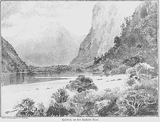
The Seaforth River is a river in New Zealand, flowing into Dusky Sound. About 9 km (5.6 mi) and 41 m (135 ft) up from Supper Cove in Dusky Sound is Lake Maree. The river rises about another 20 km (12 mi) to the north, on the slopes of the Black Giants, at about 1,300 m (4,300 ft). Like many former British Empire locations, it and its lakes have Scottish names.
Barker Range is a mountain range trending northwest–southeast and including Jato Nunatak, Mount Watt, Mount McCarthy, and Mount Burton, located at the southwest side of the Millen Range in the Victory Mountains, Victoria Land, Antarctica. It was named by the New Zealand Antarctic Place-Names Committee (NZ-APC) for James Barker, leader at Scott Base, 1972.
The Saxby Range is a broad mountain range, rising to 2,450 metres (8,040 ft), in the Victory Mountains of Victoria Land, Antarctica. It is bounded by Jutland Glacier, Tucker Glacier, Pearl Harbor Glacier, and Midway Glacier.
Grainger Falls is a waterfall in Fiordland, New Zealand. It is a combination of a tiered and fan type waterfall.

Southland is New Zealand's southernmost region. It consists mainly of the southwestern portion of the South Island and Stewart Island/Rakiura. It includes Southland District, Gore District and the city of Invercargill. Murihiku Southland is bordered by the culturally similar Otago to the north and east, and the West Coast in the extreme northwest. The region covers over 3.1 million hectares and spans 3,613 km of coast. As of June 2023, Southland has a population of 103,900, making it the eleventh-most-populous New Zealand region, and the second-most sparsely populated.

Bauza Island lies immediately south of the much larger Secretary Island in the outer reaches of Doubtful Sound / Patea, in Fiordland National Park on New Zealand's South Island. The less than one kilometre wide Patea passage to the south of the island is the main entrance to Doubtful Sound. To the north, the island is separated from Secretary Island by the narrow Te Awaatu Channel, also referred to as "The Gut", only 200 metres (660 ft) wide at its narrowest point. The waters between the two islands are protected by the Te Awaatu Channel Marine Reserve. Doubtful Sound tour boats routinely travel through this channel.
Mount Grono, previously spelled Mount Groznoz, is a 1,196-metre (3,924 ft) peak on Secretary Island, part of New Zealand's Fiordland National Park. It was named for early 19th century sealer John Grono.
Shag River is a river on Resolution Island in Fiordland, New Zealand. It rises north west of Mount Roa and flows south into the Taumoana Marine Reserve, part of Tamatea / Dusky Sound.
Newton River in the Tasman District ), flows west and then south for about 20 km (12 mi) from Mount Newton to the Buller River, 17 km (11 mi) west of Murchison. Near its mouth it is crossed by SH6 on a steel truss bridge with a 120 ft (37 m) main span and two 30 ft (9.1 m) side spans.

