Ngake is one of 43 islands in the Manihiki atoll of the Cook Islands. [1] It is the largest island, making up almost the entire north-eastern side of the atoll. The village of Tukao and Manihiki Island Airport are both located on the island.
Ngake is one of 43 islands in the Manihiki atoll of the Cook Islands. [1] It is the largest island, making up almost the entire north-eastern side of the atoll. The village of Tukao and Manihiki Island Airport are both located on the island.

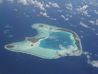
An atoll is a ring-shaped island, including a coral rim that encircles a lagoon. There may be coral islands or cays on the rim. Atolls are located in warm tropical or subtropical parts of the oceans and seas where corals can develop. Most of the approximately 440 atolls in the world are in the Pacific Ocean.

Nukulaelae is an atoll that is part of the nation of Tuvalu, and it has a population of 300. The largest settlement is Pepesala on Fangaua islet with a population of 300 people. It has the form of an oval and consists of at least 15 islets. The inhabited islet is Fangaua, which is 1.5 kilometres (0.93 mi) long and 50 to 200 metres wide. The easternmost point of Tuvalu is Niuoko islet. The Nukulaelae Conservation Area covers the eastern end of the lagoon. A baseline survey of marine life in the conservation zone was conducted in 2010.

Rakahanga is part of the Cook Islands, situated in the central-southern Pacific Ocean. The unspoilt atoll is 1,248 kilometres from the Cook Islands' capital, Rarotonga, and lies 1,111 kilometres south of the equator. Its nearest neighbour is Manihiki which is just 44 kilometres away. Rakahanga's area is 4 square kilometres (1.5 sq mi). Its highest point is approximately 5 metres above sea level. The population was 83 in the 2016 Census of Population & Dwellings. Since 2014 Rakahanga's power has been 100% solar generated. The Rakahanga-Manihiki language differs from Cook Islands Maori.

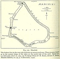
Manihiki is an atoll in the northern group of the Cook Islands known informally as the "Island of Pearls". It is located in the Northern Cook Island chain, approximately 1,299 kilometres (807 mi) north of the capital island of Rarotonga, making it one of the most remote inhabitations in the Pacific Ocean. Its name has two possible meanings: It's believed that the original name of the island was Manuhiki, inspired by the aboriginal discovers Manu coming from the word Rua Manu and Hiki meaning ashore, so the literal translation would be canoe carried ashore. The second interpretation is that the original discoverers were from Manihi, an island in Tuamotus, so the name of the island would mean Little Manihi.
The Ontong Java Plateau (OJP) is a massive oceanic plateau located in the southwestern Pacific Ocean, north of the Solomon Islands. The OJP was formed around 116 million years ago (Ma), with a much smaller volcanic event around 90 Ma. Two other southwestern Pacific plateaus, Manihiki and Hikurangi, now separated from the OJP by Cretaceous oceanic basins, are of similar age and composition and probably formed as a single plateau and a contiguous large igneous province together with the OJP. When eruption of lava had finished, the Ontong Java–Manihiki–Hikurangi plateau covered 1% of Earth's surface and represented a volume of 80 million km3 (19 million cu mi) of basaltic magma. This "Ontong Java event", first proposed in 1991, represents the largest volcanic event of the past 200 million years, with a magma eruption rate estimated at up to 22 km3 (5.3 cu mi) per year over 3 million years, several times larger than the Deccan Traps. The smooth surface of the OJP is punctuated by seamounts such as the Ontong Java Atoll, one of the largest atolls in the world.
Rakahanga-Manihiki is a Tahitic language belonging to the Polynesian language family, spoken by about 2500 people on Rakahanga and Manihiki Islands and another 2500 in other countries, mostly New Zealand and Australia. Wurm and Hattori consider Rakahanga-Manihiki as a distinct language with "limited intelligibility with Rarotongan". According to the New Zealand Maori anthropologist Te Rangi Hīroa who spent a few days on Rakahanga in the years 1920, "the language is a pleasing dialect and has closer affinities with [New Zealand] Maori than with the dialects of Tongareva, Tahiti, and the Cook Islands"
Manihiki Island Airport is a public airport on the atoll of Manihiki in the Cook Islands. The airport was built in the early 1980s, but not used for commercial flights until 1991. Originally it had no terminal, with passengers checking in under the overhang of a nearby house and waiting in the open or in the shade of nearby trees. In 2018 construction began on a purpose-built terminal.

The Northern Cook Islands is one of the two chains of atolls which make up the Cook Islands. Lying in a horizontal band between 9° and 13°30' south of the Equator, the chain consists of the atolls of Manihiki, Nassau, Penrhyn, Pukapuka, Rakahanga and Suwarrow, along with the submerged Tema Reef.

Tauhunu is both the main village on Manihiki atoll in the Cook Islands and the islet on which it is located. The village is the seat of the Manihiki Island Council. Tauhunu Islet is on the western rim of the atoll.

The 1982–83 South Pacific cyclone season was one of the most active and longest South Pacific tropical cyclone seasons on record, with 16 tropical cyclones occurring within the South Pacific basin between 160°E and 120°W. During the season tropical cyclones were monitored by the meteorological services of Australia, Fiji, French Polynesia and New Zealand. The United States Armed Forces through the Joint Typhoon Warning Center (JTWC) and Naval Pacific Meteorology and Oceanography Center (NPMOC), also monitored the basin and issued unofficial warnings for American interests. The first tropical cyclone of the season developed a day before the season officially began on October 30, while the last tropical cyclone of the season dissipated on May 16. Most of the activity during the season occurred within the central and eastern parts of the basin with French Polynesia affected by several systems.

Severe Tropical Cyclone Martin was the deadliest tropical cyclone of the 1997–98 South Pacific cyclone season. The system was first noted as a weak tropical disturbance on October 27, to the north of the Northern Cook Islands. Over the next few days atmospheric convection surrounding the system remained disorganized, as it moved towards the southwest and was affected by strong upper-level north-easterly winds and moderate to strong vertical wind shear. The system was subsequently named Martin during October 31, after it had rapidly developed further and shown a marked improvement organization.
Tukao is a village on Manihiki atoll in the Cook Islands. The village is at the northern tip of the islet of Ngake, which runs along the northern-eastern side of the atoll.
Atimono is one of 43 islands in the Manihiki atoll of the Cook Islands. It is a small islet at the southern end of Ngake and to the north of Motu Hakamaru.
Motu Hakamaru is one of 43 islands in the Manihiki atoll of the Cook Islands. It is a small islet and marks the south-eastern corner of the atoll.
Porea is one of 43 islands in the Manihiki atoll of the Cook Islands. It is a small islet which marks the southern edge of the atoll. It is separated from Tauhunu in the west and Motu Hakamaru by a large number of small islets.
Te Puka is one of 43 islands in the Manihiki atoll of the Cook Islands. It is a small islet in the south-west corner of the atoll, just inside the reef from Tauhunu.
Murihiti is one of 43 islands in the Manihiki atoll of the Cook Islands. It is a small island, in the gap in the atoll between Tauhunu and Ngake.

Te Kainga is one of 11 islands in the Rakahanga atoll of the Cook Islands. The island once served as the principal inhabited island of Rakahanga, but the settlement was moved to Rakahanga Island in the missionary era. The single village was shared by the atoll's four tribes, and was surrounded by five marae: Punariku, Avarua, Huku-wananga, Mua, and Variu.

The Central Polynesian tropical moist forests is a tropical and subtropical moist broadleaf forests ecoregion in Polynesia. It includes the northern group of the Cook Islands, the Line Islands in Kiribati, and Johnston Atoll, Jarvis Island, Palmyra Atoll, and Kingman Reef which are possessions of the United States.
10°22′50″S160°59′59″W / 10.38056°S 160.99972°W
| | This article about an island in the Cook Islands is a stub. You can help Wikipedia by expanding it. |