Aitutaki, also traditionally known as Araʻura and Utataki, is the second most-populated island in the Cook Islands, after Rarotonga. It is an "almost atoll", with fifteen islets in a lagoon adjacent to the main island. Total land area is 18.05 km2 (6.97 sq mi), and the lagoon has an area of between 50 and 74 km2. A major tourist destination, Aitutaki is the second most visited island of the Cook Islands.

Penrhyn is an atoll in the northern group of the Cook Islands in the south Pacific Ocean. The northernmost island in the group, it is located at 1,365 km (848 mi) north-north-east of the capital island of Rarotonga, 9 degrees south of the equator. Its nearest neighbours are Rakahanga and Manihiki, approximately 350 kilometres (220 mi) to the southwest. Once one of the most heavily populated atolls, it was almost completely depopulated by Peruvian slavers in 1864.

Rakahanga is part of the Cook Islands, situated in the central-southern Pacific Ocean. The unspoilt atoll is 1,248 kilometres from the Cook Islands' capital, Rarotonga, and lies 1,111 kilometres south of the equator. Its nearest neighbour is Manihiki which is just 44 kilometres away. Rakahanga's area is 4 square kilometres (1.5 sq mi). Its highest point is approximately 5 metres above sea level. The population was 83 in the 2016 Census of Population & Dwellings. Since 2014 Rakahanga's power has been 100% solar generated. The Rakahanga-Manihiki language differs from Cook Islands Maori.

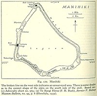
Manihiki is an atoll in the northern group of the Cook Islands known informally as the "Island of Pearls". It is located in the Northern Cook Island chain, approximately 1,299 kilometres (807 mi) north of the capital island of Rarotonga, making it one of the most remote inhabitations in the Pacific Ocean. Its name has two possible meanings: It's believed that the original name of the island was Manuhiki, inspired by the aboriginal discovers Manu coming from the word Rua Manu and Hiki meaning ashore, so the literal translation would be canoe carried ashore. The second interpretation is that the original discoverers were from Manihi, an island in Tuamotus, so the name of the island would mean Little Manihi.

Manuae is an uninhabited atoll in the southern group of the Cook Islands, 100 kilometres south-east of Aitutaki. Manuae is not administratively part of Aitutaki, however, it is part of Arutanga-Reureu-Nikaupara Constituency on Aitutaki for electoral purposes only.

Mitiʻāro, the fourth island in the Cook Islands group, is of volcanic origin. Standing in water 14,750 feet (4,500 m) deep it is four miles (6.4 km) across at its widest point.
Rakahanga-Manihiki is a Tahitic language belonging to the Polynesian language family, spoken by about 2500 people on Rakahanga and Manihiki Islands and another 2500 in other countries, mostly New Zealand and Australia. Wurm and Hattori consider Rakahanga-Manihiki as a distinct language with "limited intelligibility with Rarotongan". According to the New Zealand Maori anthropologist Te Rangi Hīroa who spent a few days on Rakahanga in the years 1920, "the language is a pleasing dialect and has closer affinities with [New Zealand] Maori than with the dialects of Tongareva, Tahiti, and the Cook Islands"

The Northern Cook Islands is one of the two chains of atolls which make up the Cook Islands. Lying in a horizontal band between 9° and 13°30' south of the Equator, the chain consists of the atolls of Manihiki, Nassau, Penrhyn, Pukapuka, Rakahanga and Suwarrow, along with the submerged Tema Reef.

Tauhunu is both the main village on Manihiki atoll in the Cook Islands and the islet on which it is located. The village is the seat of the Manihiki Island Council. Tauhunu Islet is on the western rim of the atoll.

Severe Tropical Cyclone Martin was the deadliest tropical cyclone of the 1997–98 South Pacific cyclone season. The system was first noted as a weak tropical disturbance on October 27, to the north of the Northern Cook Islands. Over the next few days atmospheric convection surrounding the system remained disorganized, as it moved towards the southwest and was affected by strong upper-level north-easterly winds and moderate to strong vertical wind shear. The system was subsequently named Martin during October 31, after it had rapidly developed further and shown a marked improvement organization.

Renewable energy in the Cook Islands is primarily provided by solar energy and biomass. Since 2011 the Cook Islands has embarked on a programme of renewable energy development to improve its energy security and reduce greenhouse gas emissions, with an initial goal of reaching 50% renewable electricity by 2015, and 100% by 2020. The programme has been assisted by the governments of Japan, Australia, and New Zealand, and the Asian Development Bank.
The Cook Islands is a net importer of energy, in the form of petroleum products. Total energy consumption was 1,677,278,000 BTU in 2017, of which 811,000,000 was in the form of oil. In 2012 47% of imported oil was used in the transport sector, 30% in aviation, and 27% for electricity generation. Electricity consumption is 31.6 GWh, from 14 MW of installed generation capacity, with most load concentrated on the main island of Rarotonga. Per-capita electricity consumption is approximately two-thirds that in the European Union. Greenhouse gas emissions total 88,810 t per year, or 10.36 t per capita.
Ngake is one of 43 islands in the Manihiki atoll of the Cook Islands. It is the largest island, making up almost the entire north-eastern side of the atoll. The village of Tukao and Manihiki Island Airport are both located on the island.
Atimono is one of 43 islands in the Manihiki atoll of the Cook Islands. It is a small islet at the southern end of Ngake and to the north of Motu Hakamaru.
Motu Hakamaru is one of 43 islands in the Manihiki atoll of the Cook Islands. It is a small islet and marks the south-eastern corner of the atoll.
Porea is one of 43 islands in the Manihiki atoll of the Cook Islands. It is a small islet which marks the southern edge of the atoll. It is separated from Tauhunu in the west and Motu Hakamaru by a large number of small islets.
Te Puka is one of 43 islands in the Manihiki atoll of the Cook Islands. It is a small islet in the south-west corner of the atoll, just inside the reef from Tauhunu.
Murihiti is one of 43 islands in the Manihiki atoll of the Cook Islands. It is a small island, in the gap in the atoll between Tauhunu and Ngake.

Te Kainga is one of 11 islands in the Rakahanga atoll of the Cook Islands. The island once served as the principal inhabited island of Rakahanga, but the settlement was moved to Rakahanga Island in the missionary era. The single village was shared by the atoll's four tribes, and was surrounded by five marae: Punariku, Avarua, Huku-wananga, Mua, and Variu.