Related Research Articles

An evaporite is a water-soluble sedimentary mineral deposit that results from concentration and crystallization by evaporation from an aqueous solution. There are two types of evaporite deposits: marine, which can also be described as ocean deposits, and non-marine, which are found in standing bodies of water such as lakes. Evaporites are considered sedimentary rocks and are formed by chemical sediments.

The Coral Sea is a marginal sea of the South Pacific off the northeast coast of Australia, and classified as an interim Australian bioregion. The Coral Sea extends 2,000 kilometres (1,200 mi) down the Australian northeast coast. Most of it is protected by the French Natural Park of the Coral Sea and the Australian Coral Sea Marine Park. The sea was the location for the Battle of the Coral Sea, a major confrontation during World War II between the navies of the Empire of Japan, and the United States and Australia.
The Western Desert language, or Wati, is a dialect cluster of Australian Aboriginal languages in the Pama–Nyungan family.

The Yilgarn Craton is a large craton that constitutes a major part of the Western Australian land mass. It is bounded by a mixture of sedimentary basins and Proterozoic fold and thrust belts. Zircon grains in the Jack Hills, Narryer Terrane have been dated at ~4.27 Ga, with one detrital zircon dated as old as 4.4 Ga.
The geology of Australia includes virtually all known rock types, spanning a geological time period of over 3.8 billion years, including some of the oldest rocks on earth. Australia is a continent situated on the Indo-Australian Plate.

The Petermann Orogeny was an Australian intracontinental event that affected basement rocks of the northern Musgrave Province and Ediacaran (Proterozoic) sediments of the (now) southern Amadeus Basin between ~550-535 Ma. The remains are seen today in the Petermann Ranges.
The Centralian Superbasin is a large intracratonic sedimentary basin which occupied a large area of central, southern and western Australia during much of the Neoproterozoic Era.
The Australian Shield is a geological feature known as a shield that occupies more than half of the continent of Australia. The word shield is used because it refers to ancient, molten rock which has cooled and solidified.
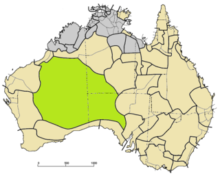
The Amadeus Basin is a large (~170,000 km2) intracratonic sedimentary basin in central Australia, lying mostly within the southern Northern Territory, but extending into the state of Western Australia.
The Georgina Basin is a large intracratonic sedimentary basin in central and northern Australia, lying mostly within the Northern Territory and partly within Queensland. It is named after the Georgina River which drains part of the basin. Deposition of locally up to c. 4 km of marine and non-marine sedimentary rocks took place from the Neoproterozoic to the late Paleozoic. Along with other nearby sedimentary basins of similar age, the Georgina Basin is believed to have once been part of the hypothetical Centralian Superbasin, that was fragmented during episodes of tectonic activity.
The McArthur Basin is a large intracratonic sedimentary basin in northern Australia, with an exposed area of about 180,000 km2. Most of it lies within the northeastern Northern Territory, but extends over the border into the state of Queensland. The basin contains thick marine and non-marine sedimentary rocks which were deposited from the late Paleoproterozoic to the early Mesoproterozoic. The basin also contains some volcanic rocks and related intrusive igneous rocks. The McArthur Basin hosts the world-class McArthur River mine (HYC) zinc-lead-silver deposit and several smaller mineral and diamond deposits.
The Alice Springs Orogeny was a major intraplate tectonic episode in central Australia responsible for the formation of a series of large mountain ranges. The deformation associated with the Alice Spring Orogeny caused the vertically-tilted sandstone layers of the iconic Uluru/Ayers Rock.
The Eromanga Basin is a large Mesozoic sedimentary basin in central and northern Australia. It covers parts of Queensland, the Northern Territory, South Australia, and New South Wales, and is a major component of the Great Artesian Basin. The Eromanga Basin covers 1,000,000 km2 and overlaps part of the Cooper Basin.
Mount Doreen Station is a 7,337-square-kilometre (2,833 sq mi) pastoral lease operating as a cattle station in the Northern Territory of Australia.

Hann Range is a mountain range in the Northern Territory of Australia located in central Australia approximately 120 kilometres (75 mi) north of Alice Springs.
Ngalia, Ngaliya or Ngalea may refer to:

The Owambo Basin is a sedimentary basin located on the Congo Craton in Southern Africa that extends from southern Angola into Namibia and includes the Etosha Pan. It is bound on the southern and western sides by the Damara Belt in Northern Namibia, and by the Cubango River to the East. The northern boundary is scientifically disputed, but is currently mapped by most stratigraphers to include southern Angola with the boundary set at the Kunene River. The Owambo Basin is host to two famous regions: Tsumeb, a major Namibian city and site of a formerly active copper mine with exceptional mineralogical variability producing museum quality rare specimens, and Etosha National Park, the largest protected wildlife sanctuary in Namibia centered around Etosha Pan.
The Ngalia, or Ngalea, are an Aboriginal Australian people of the Western Desert cultural bloc resident in land extending from Western Australia to the west of South Australia. They are not to be confused with the Ngalia of the Northern Territory.
The Ngaliya (Ngalia) are an indigenous Australian people of the Northern Territory who speak a dialect of the Warlpiri language. They are not to be confused with the Ngalia of the Western Desert.

The Bonaparte Basin is a sedimentary basin in Western Australia and the Northern Territory of Australia. Its total area is approximately 270,000 square kilometres (100,000 sq mi), most of which is offshore.
References
- ↑ Wells AT, Moss, FJ (1983). "The Ngalia Basin, Northern Territory: stratigraphy and structure". Bureau of Mineral Resources, Australia, Bulletin 212.