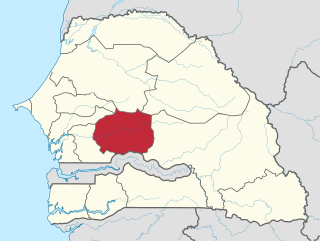
Senegal is subdivided into 14 regions, each of which is administered by a Conseil Régional elected by population weight at the arrondissement level. Senegal is further subdivided into 46 departments, 103 arrondissements and by collectivités locales which elect administrative officers. Three of these regions were created on 10 September 2008, when Kaffrine Region was split from Kaolack, Kédougou region was split from Tambacounda, and Sédhiou region was split from Kolda.

The 14 regions of Senegal are subdivided into 46 departments and 103 arrondissements and by collectivités locales which elect administrative officers.

Kaffrine is the capital town of Kaffrine Region of Senegal.

The cuisine of the Democratic Republic of the Congo varies widely, representing the food of indigenous people. Cassava, fufu, rice, plantain and potatoes are generally the staple foods.

The departments of Senegal are subdivided into arrondissements. As of 2008 there were 133. The arrondissements are listed below, by department:

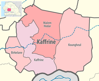
Kaffrine department is one of the 46 departments of Senegal, and is located in the Kaffrine Region, formerly part of the Kaolack Region.

Koungheul is the name of one of 46 departments of Senegal, as well as the name of Koungheul Arrondissement and the commune of Koungheul, the principal settlement of the department.
Koungheul is a town and urban commune in central Senegal in the department of the same name. It lies in the region of Kaffrine and is situated between the towns of Kaolack and Tambacounda. The population is 31,149, most of whom are Wolof people.

Kaffrine region is a region of Senegal. It was created in 2008.

The Communes of Senegal are the fourth-level administrative divisions in Senegal. There are some 121 communes in Senegal which have urban status, apart from 46 communes d'arrondissement in the large towns and 370 rural communities in the countryside.

Birkilane department is one of the 46 departments of Senegal and is located in the Kaffrine region. It was created as part of the new region in 2008.

Malem Hodar department is one of the 46 departments of Senegal, and is located in the Kaffrine region. It was created as part of the new region in 2008.

Rural communities (CR) are the fourth-level administrative divisions in Senegal. They are administrative subdivisions comprising the villages, but are distinct from the urban communes and municipalities concerning medium or large towns.
Keur Mboucki Arrondissement is an arrondissement of the Kaffrine Department in the Kaffrine Region of Senegal.

Matomb, located in the Nyong-et-Kéllé department of Cameroon's Centre Region, is a commune situated approximately 65 kilometers southwest of Yaoundé. It serves as the administrative center for the arrondissement bearing the same name. The commune encompasses several villages, including Bingongog, Bomtol, Boumbone, Kombeng, Lamal-Pouguè, Lissé, Mambine, Mandoga, Mandoumba, Manguèn I, Manguèn II, Manyaï, Mawel, Mayebeg, Mayos, Mbemndjock, Mbeng, Nganda, Ngoung, Nkenglikok, Nkongtock, and Pan-Pan.
Birkilane is a town and urban commune in Senegal. It is the principal municipality and administrative centre of Birkilane Department in Kaffrine Region, about 30 km from the town of Kaolack.

Malem Hodar is a town and urban commune in Senegal. It is the principal municipality and administrative centre of the Malem Hodar Department of the Kaffrine Region.
Mabo is an arrondissement in Kaffrine Department, Kaffrine Region, Senegal.
Gniby is an arrondissement of Kaffrine Department in Kaffrine Region in Senegal.
Katakel is an arrondissement of Kaffrine in Kaffrine Region in Senegal.


