Ngangie is one of 11 islands in the Rakahanga atoll of the Cook Islands. [1] It is a motu on the east of the atoll, between the islets of Huananui and Akaro.
Ngangie is one of 11 islands in the Rakahanga atoll of the Cook Islands. [1] It is a motu on the east of the atoll, between the islets of Huananui and Akaro.

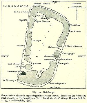
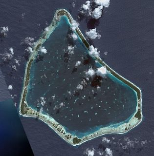
Rakahanga is part of the Cook Islands, situated in the central-southern Pacific Ocean. The unspoilt atoll is 1,248 kilometres from the Cook Islands' capital, Rarotonga, and lies 1,111 kilometres south of the equator. Its nearest neighbour is Manihiki which is just 44 kilometres away. Rakahanga's area is 4 square kilometres (1.5 sq mi). Its highest point is approximately 5 metres above sea level. The population was 83 in the 2016 Census of Population & Dwellings. Since 2014 Rakahanga's power has been 100% solar generated. The Rakahanga-Manihiki language differs from Cook Islands Maori.
Manihiki is an island in the northern group of the Cook Islands known informally as the "Island of Pearls". It is approximately 1,299 kilometres (807 mi) north of the capital island of Rarotonga, making it one of the most remote inhabitations in the Pacific Ocean. Its name has two possible meanings: It's believed that the original name of the island was Manuhiki, inspired by the aboriginal discovers Manu coming from the word Rua Manu and Hiki meaning ashore, so the literal translation would be canoe carried ashore. The second interpretation is that the original discoverers were from Manihi, an island in Tuamotus, so the name of the island would mean Little Manihi.

Tauhunu is both the main village on Manihiki atoll in the Cook Islands and the islet on which it is located. The village is the seat of the Manihiki Island Council. Tauhunu Islet is on the western rim of the atoll.
Tukao is a village on Manihiki atoll in the Cook Islands. The village is at the northern tip of the islet of Ngake, which runs along the northern-eastern side of the atoll.
Ngake is one of 43 islands in the Manihiki atoll of the Cook Islands. It is the largest island, making up almost the entire north-eastern side of the atoll. The village of Tukao and Manihiki Island Airport are both located on the island.
Motu Hakamaru is one of 43 islands in the Manihiki atoll of the Cook Islands. It is a small islet and marks the south-eastern corner of the atoll.
Porea is one of 43 islands in the Manihiki atoll of the Cook Islands. It is a small islet which marks the southern edge of the atoll. It is separated from Tauhunu in the west and Motu Hakamaru by a large number of small islets.
Te Puka is one of 43 islands in the Manihiki atoll of the Cook Islands. It is a small islet in the south-west corner of the atoll, just inside the reef from Tauhunu.
Murihiti is one of 43 islands in the Manihiki atoll of the Cook Islands. It is a small island, in the gap in the atoll between Tauhunu and Ngake.

Mangarongaro is an islet in Penrhyn Atoll (Tongareva) in the Cook Islands. The islet makes up most of the southwestern rim of the atoll, south of Moananui Islet and west of Atiati. The islet was once inhabited, and contains the remains of two marae, Rakahanga and Te Vete.
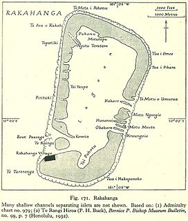
Te Kainga is one of 11 islands in the Rakahanga atoll of the Cook Islands. The island once served as the principal inhabited island of Rakahanga, but the settlement was moved to Rakahanga Island in the missionary era. The single village was shared by the atoll's four tribes, and was surrounded by five marae: Punariku, Avarua, Huku-wananga, Mua, and Variu.
Rakahanga Island is one of 11 islands in the Rakahanga atoll of the Cook Islands. It is on the southern edge of the lagoon, and the village of Nivano and the atoll's harbour are located on the island.
Huananui is one of 11 islands in the Rakahanga atoll of the Cook Islands. It is on the east of the atoll, between the islets of Ngangie and Mahuta.
Mahuta is one of 11 islands in the Rakahanga atoll of the Cook Islands. It is on the east of the atoll, between the islets of Huananui and Okakara.
Okakara is one of 11 islands in the Rakahanga atoll of the Cook Islands. It is on the east of the atoll, between the islets of Mahuta and Rakahanga Island.
Akaro is one of 11 islands in the Rakahanga atoll of the Cook Islands. It is on the east of the atoll, between the islets of Tetukono and Okakara.
Te Motu o Umurua is one of 11 islands in the Rakahanga atoll of the Cook Islands. It is on the east of the atoll, next to the island of Tetukono.
Tetukono is one of 11 islands in the Rakahanga atoll of the Cook Islands. It makes up the northern and northeastern edges of the atoll, and is between the islands of Tetaha Kiraro and Akaro.
Tetaha Kiraro is one of 11 islands in the Rakahanga atoll of the Cook Islands. It is on the west of the atoll, between the islands of Tetukono and Paerangi.
Paerangi is one of 11 islands in the Rakahanga atoll of the Cook Islands. It is in the southwest of the atoll, between the islands of Tetaha Kiraro and Te Kainga.
Coordinates: 10°1′11.88″S161°4′59.91″W / 10.0199667°S 161.0833083°W
| This Cook Islands location article is a stub. You can help Wikipedia by expanding it. |