Nhamatanda

Last updated

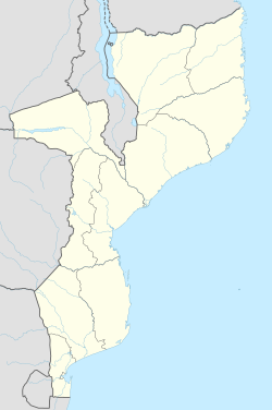
Nhamatanda is a town in the Sofala Province of Mozambique. It is the administrative center of Nhamatanda District. [1] It lies along the Beira Corridor between Harare in Zimbabwe and Beira, Mozambique's second-largest city. It was largely destroyed by Cyclone Idai in March 2019.

Name

Rural hospital of Nhamatanda Hospital Rural de Nhamatanda, Sofala, Mozambique, VOA.jpg
Rural hospital of Nhamatanda

Nhamatanda has had many names. Early in its history, it was known as "Bambu Crick". [1] In the local dialect of Chisena, this means "Mr. Crick" - a reference to a British landowner in the area. English-speakers, however, referred to the place as "Bamboo Creek", a reference to a small river near the town. Which name came first is unknown, and many residents of the area refer variously to these different stories.

Nova Fontesvila, the name given to the same place by the Portuguese (who inhabited the area along with the British), was founded in 1898 and named after Fontes Pereira de Melo, a Portuguese marquis. The names of Nova Fontesvila and Bamboo Crick existed simultaneously.

In the 1920s, the town of Nova Fontesvila was officially renamed "Vila Machado", a reference to the Portuguese engineer responsible for building the railroad from Beira to Harare. [1] Machado is also the Portuguese word for "axe", and many Mozambican residents of the area refer to the fact that the railroad was built through a large grove of trees, all of which needed to be cut down by black African workers.

The current name, Nhamatanda, was given in 1975 at Mozambican independence. It derives from the name of the river near the town and through the district. In Chisena, the word Nhamatanda may be derived from words meaning "large logs", It is said that the river has been strong enough, before current dams were built, to pass large logs down its length.

Coordinates: 19°16′S34°13′E / 19.267°S 34.217°E / -19.267; 34.217

Related Research Articles

Mozambique Country on the east coast of Southern Africa

Mozambique, officially the Republic of Mozambique, is a country located in Southern Africa bordered by the Indian Ocean to the east, Tanzania to the north, Malawi and Zambia to the northwest, Zimbabwe to the west, and Eswatini (Swaziland) and South Africa to the southwest. The sovereign state is separated from the Comoros, Mayotte and Madagascar by the Mozambique Channel to the east. The capital and largest city of Mozambique is Maputo.

Mozambique was a Portuguese colony, overseas province and later a member state of Portugal. It gained independence from Portugal in 1975.

Portuguese Mozambique 1498-1975 Portuguese possession in East Africa

Portuguese Mozambique or Portuguese East Africa were the common terms by which Mozambique was designated during the historic period when it was a Portuguese colony. Portuguese Mozambique originally constituted a string of Portuguese possessions along the south-east African coast, and later became a unified colony, which now forms the Republic of Mozambique.

Maputo Capital and chief port of Mozambique

Maputo, officially named Lourenço Marques until 1976, is the capital and most populous city of Mozambique. The city is named after chief Maputsu I of the Tembe clan, a subgroup of Tsonga people. Located near the southern end of the country, it is positioned within 120 km of the Eswatini and South Africa borders. The city has a population of 1,088,449 distributed over a land area of 347,69 km2. The Maputo metropolitan area includes the neighbouring city of Matola, and has a total population of 2,717,437. Maputo is a port city, with an economy centered on commerce. It is also noted for its vibrant cultural scene and distinctive, eclectic architecture.

Mutare City in Manicaland, Zimbabwe

Mutare is the fourth largest city in Zimbabwe, with an urban population of approximately 188,243 and rural population of approximately 260,567. It is the capital of Manicaland province.

Beira, Mozambique Place in Sofala Province, Mozambique

Beira is the capital and largest city of Sofala Province, where the Pungwe River meets the Indian Ocean, in the central region of Mozambique. It is the fourth-largest city by population in Mozambique, after Maputo, Matola and Nampula. Beira had a population of 397,368 in 1997, which grew to 530,604 in 2019. A coastal city, it holds the regionally significant Port of Beira, which acts as a gateway for both the central interior portion of the country as well as the land-locked nations of Zimbabwe, Zambia and Malawi.

The Ndau are an ethnic group which inhabits the areas in south-eastern Zimbabwe in the districts of Chipinge and Chimanimani in which they are natives. They are also found in parts of Bikita, in the Zambezi valley, in central Mozambique all the way to the coast and in central Malawi. The name "Ndau" is a derivation from the people's traditional salutation "Ndau wee!" in greetings and other social settings. When the Ngoni observed this, they called them the Ndau people, the name itself meaning the land, the place or the country in their language. Some suggestions are that the name is derived from the Nguni words "Amading'indawo" which means "those looking for a place" as this is what the Gaza Nguni called them and the name then evolved to Ndau. This is erroneous as the natives are described in detail to have already been occupying parts of Zimbabwe and Mozambique in 1500s by Joao dos Santos. The five largest Ndau groups are the Magova; the Mashanga; the Vatomboti, the Madanda and the Teve. Ancient Ndau People met with the Khoi/San during the first trade with the Arabs at Shiriyandenga currently known as Mapungumbye. They Traded with Arabs with “Mpalu” “Njeti” and “Vukotlo’’ these are the red,white and blue coloured cloths together with golden beads. Ndau people traded traditional herbs, spiritual powers, Animal skins and bones.

Chimoio Place in Manica Province, Mozambique

Chimoio is the capital of Manica Province in Mozambique. It is the fifth-largest city in Mozambique.

Grande Hotel Beira architectural structure

The Grande Hotel Beira was a luxury hotel in Beira, Mozambique. It was opened in 1954 and operated until 1974, when it was closed due to lack of guests. The building was used as a military base in the Mozambican Civil War, and it is currently home to over 3500 squatters.

Pungwe River river in Mozambique

Pungwe River is a 400 km (250 mi) long river in Zimbabwe and Mozambique. It rises below Mount Nyangani in the Eastern Highlands of Zimbabwe and then flows southeasteastward through the Manica and Sofala provinces of Mozambique. the Pungwe enters the Urema Valley, the southernmost portion of the Great Rift Valley, where it forms the southern boundary of Gorongosa National Park. The Urema River joins it, and the river follows the rift valley southward. Large seasonal wetlands form around the Pungwe and Urema rivers in the rift valley section. It empties into the Mozambique Channel at Beira, forming a large estuary. It is one of the major rivers of Mozambique and often causes floods.

The culture of Mozambique is in large part derived from its history of Bantu, Swahili, and Portuguese rule, and has expanded since independence in 1975. The majority of its inhabitants are black Africans. Its main language is Portuguese. Its median religion is Roman Catholicism, but only about 40% of the inhabitants are Christian. It has a rich history in the areas of arts, cuisine, and entertainment.

Mozambican Portuguese Dialect

Mozambican Portuguese refers to the varieties of Portuguese spoken in Mozambique. Portuguese is the official language of the country.

Dondo District District in Sofala, Mozambique

Dondo District is a district of Sofala Province in Mozambique. The principal town is Dondo. The district is located in the center of the province, and borders with Muanza District in the north, the city of Beira and Buzi District in the south, and with Nhamatanda District in the west. In the east, the district is limited by the Indian Ocean. The area of the district is 2,306 square kilometres (890 sq mi). It has a population of 142,387 as of 2007.

Gondola District District in Manica, Mozambique

Gondola District is a district of Manica Province in western Mozambique. The principal town is Gondola. The area of the district is 5,739 square kilometres (2,216 sq mi). It has a population of 262,412 as of 2007.

Manica District District in Manica, Mozambique

Manica District is a district of Manica Province in western Mozambique. The principal town is Manica. The district is located in the west of the province, and borders with Báruè District in the north, Vanduzi District in the east, Sussundenga District in the south, and with Zimbabwe in the west. The area of the district is 4,594 square kilometres (1,774 sq mi). It has a population of 213,206 as of 2007.

Buzi District District in Sofala, Mozambique

Buzi District is a district of Sofala Province in Mozambique. The principal town is Búzi. The district is located in the southeast of the province, and borders with Nhamatanda District in the north, Dondo District in the northeast, Machanga District in the south, Chibabava District in the southwest, Sussundenga District of Manica Province in the west, and with Gondola District of Manica Province in the northwest. The area of the district is 7,329 square kilometres (2,830 sq mi). It has a population of 159,614 as of 2007.

Nhamatanda District District in Sofala, Mozambique

Nhamatanda District is a district of Sofala Province in Mozambique. The principal town is Nhamatanda. The district is located in the center of the province, and borders with Gorongosa District in the north, Muanza District in the northeast, Dondo District in the east, Buzi District in the south, and with Gondola District of Manica Province in the west. The area of the district is 3,987 square kilometres (1,539 sq mi). It has a population of 210,757 as of 2007.

History of rail transport in Mozambique

The history of rail transport in Mozambique began in the latter years of the nineteenth century.

Sena railway railway line in Africa

Sena railway, also called Shire Highlands railway, Dondo-Malawi railway and North-South Malawi railway, is a railway that connects the city of Dondo, Mozambique, to the city from Chipata, in Zambia. It is c. 1000 km long, in a 1067 mm gauge.

Mutare District District in Zimbabwe

Mutare District is a district in Manicaland Province of eastern Zimbabwe. The district headquarters is the city of Mutare.

References

  1. 1 2 3 "Perfil do Distrito do Nhamatanda" (PDF) (in Portuguese). Ministry of State Administration. 2005. Retrieved 9 November 2016.