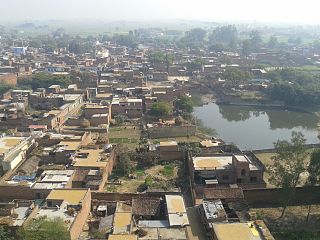
Zamania is a town in the Indian state of Uttar Pradesh. Its municipal council is subordinate to the Ghazipur District.
Reotipur is a village located in the Ghazipur district of Uttar Pradesh, India. With a population of 28833, it is the largest village in Seorai Tehsil of the Ghazipur district.
Phooli village is located between Dildarnagar and Zamania in Ghazipur district in the Indian state of Uttar Pradesh. The village is close to the Ganges river.
Suhwal is a village in the Kamsar region of Ghazipur district under Reotipur block. It is situated on Ghazipur to Buxar Road 8 km (5 mi) from Ghazipur City. Its population is 10,814. The Village is quite old. It has its own local administration under the Panchayati Raj system, with Gram Pradhan as head of local administration. There are two Government Secondary Schools, three Government Primary Schools and some privately run Schools. There is a small permanent Market in the western side of the Village and also a weekly Market. Suhwal is a center of Shopping and Primary Education for many other small villages situated on its fringe.
Dildarnagar Kamsar or Kamsaar, is a Pargana or a region of 32 places around Karamnasa river in Ghazipur district, and Kaimur District of Uttar Pradesh, and Bihar, India. Of whom main mouzas being 19. It is a large settlement of pathans mostly Khanzada Pathans and Afghan Pathans.
Amir Chak is a village in Kamsaar in the Indian state of Uttar Pradesh.
Dildarnagar Gaon also known as Deendarnagar is a neighbourhood in Dildarnagar Town of Kamsaar in Ghazipur District, India. It is 4.5 km from Phooli and 11 km from Zamania. It was the capital of Dildarnagar estate.

Saraila is a village in Kamsaar in the Indian state of Uttar Pradesh.Saraila is a village in Zamania Tehsil in Ghazipur District of Uttar Pradesh, India. It belongs to Varanasi Division. It is located 30 km to the south of District headquarters Ghazipur. 11 km from Bhadauraa. 372 km from State capital Lucknow. The village was also a part of Daudpur Estate which had its capital at Dewaitha.
Tajpur (officially known as Tiwaripur) in nebourhood in Dildarnagar of Dildarnagar Kamsar in Ghazipur district of Uttar Pradesh, India.
Fufuao or Rampur Phuphuaon is a village in Dildarnagar Kamsar in the Indian state of Uttar Pradesh.
Noble Senior Secondary School is an intermediate school located near the town of Dildarnagar in Ghazipur, Uttar Pradesh, India, it is situated at Dildarnagar to Dewaitha village road.
Nawali is a village in Seorai tehsil of Ghazipur District, Uttar Pradesh, India.
Faridpur is a village of Dildarnagar Kamsar located in Ghazipur District of Uttar Pradesh, India. Faridpur was part of Usia village but was later separated from Usia and was made a new village in 2016, when Seorai tehsil was made. Almost 200 Kamsaar Pathans Live in the villages as of 2011.
Palia is a village of Dildarnagar Kamsar located in Ghazipur District of Uttar Pradesh, India.
Sultanpur is a Hamlet of Dildarnagar Kamsar located in Ghazipur District of Uttar Pradesh, India.

Zamania Canal is one of the largest canals located in Ghazipur District. The idea for the canal was given in 1910 and the plan was passed in 1911, but the canal was established in year 1912 for the better irrigation of Zamania tehsil. It starts from Chakkah Bandh and ends on the banks of Karmanasa River near Bara Village of Seorai Teshsil. It irrigates about 61,863 acres of land in Zamania tehsil. Its average width is 110 ft.
Sarhuja is a village of Dildarnagar Kamsar located in Zamania tehsil of Ghazipur district, Uttar Pradesh, India. The village have large population of Kamsaar Pathaans.
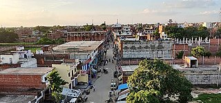
Dildarnagar is a municipality in Kamsaar of Ghazipur District, Uttar Pradesh, India. Dildarnagar is a fast-developing town. It is located 34 km from Ghazipur. It is also known as the heart of the Kamsaar-o-bar region. The total area of Dildarnagar includes Fatehpur Bazar, Dildarnagar Gao, and Nirahukapura. These four neighbourhoods form the town of Dildarnagar. As of the 2011 census, the population of Dildarnagar was 28,913 and the town had an area of 1,995.95 hectares. Dildarnagar is on the road from Varanasi to Buxar. It was also the capital of Dildarnagar Estate.

Dewaitha is a village in Dildarnagar Kamsar, Ghazipur, India, on the banks of the Karmanasa River. The village had a population of 7,706 as of the 2011 Census of India and a land area of 1,043 acres. Most of the people living in the village are Kamsar Pathan.