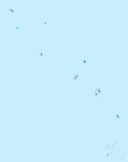
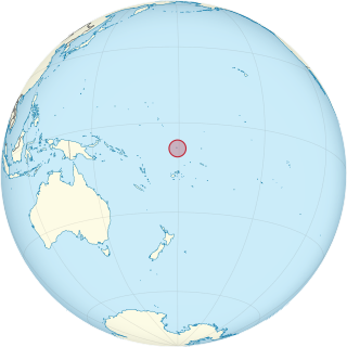
Tuvalu is an island country in the Polynesian subregion of Oceania, surrounded by the Pacific Ocean and situated about midway between Hawaii and Australia. The country lies east-northeast of the Santa Cruz Islands, northeast of Vanuatu, southeast of Nauru, south of Kiribati, west of Tokelau, northwest of Samoa and Wallis and Futuna, and north of Fiji. It is composed of three reef islands and six atolls spread out between the latitude of 5° to 10° south and longitude of 176° to 180°, west of the International Date Line. Tuvalu has a population of 10,507. The total land area of the islands of Tuvalu is 26 square kilometres (10 sq mi).

The Western Pacific nation of Tuvalu, formerly known as the Ellice Islands. It is situated 4,000 kilometers (2,500 mi) northeast of Australia and is approximately halfway between Hawaii and Australia. It lies east-northeast of the Santa Cruz Islands, southeast of Nauru, south of Kiribati, west of Tokelau, northwest of Samoa and Wallis and Futuna and north of Fiji. It is a very small island country of and is 26 km2 (10 sq mi). Due to the spread out islands it has the 38th largest Exclusive Economic Zone of 749,790 km2 (289,500 sq mi).
Telecommunications in Tuvalu cover Tuvalu's 6 atolls and 3 reef islands. The islands of Tuvalu rely on satellite dishes for communication and internet access.
The first inhabitants of Tuvalu were the Polynesians, so the origins of the people of Tuvalu can be traced to the spread of humans out of Southeast Asia, from Taiwan, via Melanesia and across the Pacific islands of Polynesia.
Tuvalu is a Polynesian island nation located in the Pacific Ocean, midway between Hawaii and Australia, with a population of 11,192 per the 2017 census. The economy of Tuvalu is constrained by its remoteness and lack of economies of scale. Government revenues largely come from fishing licences ; direct grants from international donors ; and income from the Tuvalu Trust Fund. The lease of its highly fortuitous .tv Top Level Domain (TLD) also contributes revenue. The sale of stamps since the independence of Tuvalu in 1976 has been an important source of revenue for the country and government. However, such revenue has significantly declined in recent years. Tuvalu has hardly any tourism. It has no tour guides, tour operators or organised activities and no cruise ships visit.

Nanumea is the northwesternmost atoll in the Polynesian nation of Tuvalu, a group of nine coral atolls and islands spread over about 400 miles (640 km) of Pacific Ocean just south of the equator and west of the International Date Line. Nanumea is 4 km2 (1.5 sq mi) with a population of 512 people.

Fongafale is the largest of Funafuti's islets in Tuvalu. It is a long narrow sliver of land, 12 kilometres long and between 10 and 400 metres wide, with the South Pacific Ocean and reef on the east and the protected lagoon on the west. The north part is the Tengako peninsula, and Funafuti International Airport runs from northeast to southwest on the widest part of the island, with the village and administrative centre of Vaiaku on the lagoon side.

Nukulaelae is an atoll that is part of the nation of Tuvalu, and it has a population of 300. The largest settlement is Pepesala on Fangaua islet with a population of 300 people. It has the form of an oval and consists of at least 15 islets. The inhabited islet is Fangaua, which is 1.5 kilometres (0.93 mi) long and 50 to 200 metres wide. The easternmost point of Tuvalu is Niuoko islet. The Nukulaelae Conservation Area covers the eastern end of the lagoon. A baseline survey of marine life in the conservation zone was conducted in 2010.
The Congregational Christian Church of Tuvalu, commonly the Church of Tuvalu, is the state church of Tuvalu, although in practice this merely entitles it to "the privilege of performing special services on major national events". Its adherents comprise about 97% of the ~11,000 inhabitants of the archipelago, and theologically it is part of the Reformed tradition.

The Papahānaumokuākea Marine National Monument is a World Heritage listed U.S. National Monument encompassing 583,000 square miles (1,510,000 km2) of ocean waters, including ten islands and atolls of the Northwestern Hawaiian Islands. Created in June 2006 with 140,000 square miles (360,000 km2), it was expanded in August 2016 by moving its border to the limit of the exclusive economic zone, making it one of the world's largest protected areas. It is internationally known for its cultural and natural values as follows:
"The area has deep cosmological and traditional significance for living Native Hawaiian culture, as an ancestral environment, as an embodiment of the Hawaiian concept of kinship between people and the natural world, and as the place where it is believed that life originates and to where the spirits return after death. On two of the islands, Nihoa and Mokumanamana, there are archaeological remains relating to pre-European settlement and use. Much of the monument is made up of pelagic and deepwater habitats, with notable features such as seamounts and submerged banks, extensive coral reefs and lagoons."
Fualopa is an islet of Funafuti, Tuvalu. It is part of the Funafuti Conservation Area, established in 1996 with the aim of preserving the natural fauna and flora of the area. Fualopa hosts a breeding colony of black noddy.
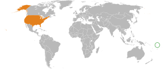
Tuvalu – United States relations are bilateral relations between Tuvalu and the United States.
The following outline is provided as an overview of and topical guide to Tuvalu:

Funafuti is an atoll and the capital of the island nation of Tuvalu. It has a population of 6,320 people, making it the country's most populated atoll, with 60.15 percent of Tuvalu's population. It is a narrow sweep of land between 20 and 400 metres wide, encircling a large lagoon 18 km long and 14 km wide. The average depth in the Funafuti lagoon is about 20 fathoms. With a surface of 275 square kilometres (106.2 sq mi), it is by far the largest lagoon in Tuvalu. The land area of the 33 islets aggregates to 2.4 square kilometres (0.9 sq mi), less than one percent of the total area of the atoll. Cargo ships can enter Funafuti's lagoon and dock at the port facilities on Fongafale.
Renewable energy in Tuvalu is a growing sector of the country's energy supply. Tuvalu has committed to becoming the first country to get 100% of its electricity from renewable energy sources by 2020. This is considered possible because of the small size of the population of Tuvalu and its abundant solar energy resources due to its tropical location. It is somewhat complicated because Tuvalu consists of nine inhabited islands. The Tuvalu National Energy Policy (TNEP) was formulated in 2009, and the Energy Strategic Action Plan defines and directs current and future energy developments so that Tuvalu can achieve the ambitious target of 100% renewable energy for power generation by 2020. The program is expected to cost 20 million US dollars and is supported by the e8, a group of 10 electric companies from G8 countries. The Government of Tuvalu worked with the e8 group to develop the Tuvalu Solar Power Project, which is a 40 kW grid-connected solar system that is intended to provide about 5% of Funafuti’s peak demand, and 3% of the Tuvalu Electricity Corporation's annual household consumption.

Global warming is particularly threatening in Tuvalu. This is because the average height of the islands is less than 2 metres (6.6 ft) above sea level, with the highest point of Niulakita being about 4.6 metres (15 ft) above sea level. Between 1971 and 2014, during a period of global warming, Tuvalu islands have increased in size, according to aerial photography and satellite imagery. Over four decades, there was a net increase in land area in Tuvalu of 73.5 ha (2.9%), although the changes were not uniform, with 74% of land increasing in size and 27% of land decreasing in size. The sea level at the Funafuti tide gauge has risen at 3.9 mm per year, which is approximately twice the global average.

Glover's Reef is a partially submerged atoll located off the southern coast of Belize, approximately 45 kilometres from the mainland. It forms part of the outermost boundary of the Belize Barrier Reef, and is one of its three atolls, besides Turneffe Atoll and Lighthouse Reef.
The 2011 Tuvalu drought was a period of severe drought afflicting Tuvalu, a South Pacific island country of approximately 10,500 people, in the latter half of 2011. A state of emergency was declared on September 28, 2011; with rationing of available fresh-water. The La Niña event that caused the drought ended in April–May 2012. By August 2012 the El Niño-Southern Oscillation (ENSO) Conditions indicated that the tropical Pacific Ocean was on the brink of an El Niño event.
The Funafuti Conservation Area is a marine conservation area covering 33 square kilometers of reef, lagoon and motu (islets) on the western side of Funafuti atoll in Tuvalu. The marine environment of the conservation area includes reef, lagoon, channel and ocean; and are home to many species of fish, corals, algae and invertebrates. The islets are nesting sites for the green sea turtle and Fualopa hosts a breeding colony of black noddy.

Women in Tuvalu continue to maintain a traditional Polynesian culture within a predominantly Christian society. Tuvaluan cultural identity is sustained through an individual’s connection to their home island. In the traditional community system in Tuvalu, each family has its own task, or salanga, to perform for the community. The skills of a family are passed on from parents to children. The women of Tuvalu participate in the traditional music of Tuvalu and in the creation of the art of Tuvalu including using cowrie and other shells in traditional handicrafts. There are opportunities of further education and paid employment with non-government organisations (NGOs) and government enterprises, education and health agencies being the primary opportunities for Tuvaluan women.