Related Research Articles

Abia State is a state in the South-East geopolitical zone of Nigeria, it is bordered to the north and northeast by the states of Enugu, and Ebonyi, Imo State to the west, Cross River State to the east, Akwa Ibom State to the southeast, and Rivers State to the south. It takes its name from the acronym for four of the state's most populated regions: Aba, Bende, Isuikwuato, and Afikpo. The state capital is Umuahia while the largest city and commercial centre is Aba.

Owerri is the capital city of Imo State in Nigeria, set in the heart of Igboland. It is also the state's largest city, followed by Orlu, Okigwe and Ohaji/Egbema. Owerri consists of three Local Government Areas including Owerri Municipal, Owerri North and Owerri West, it has an estimated population of about 1,401,873 as of 2016 and is approximately 100 square kilometres (40 sq mi) in area. Owerri is bordered by the Otamiri River to the east and the Nworie River to the south. The Owerri Slogan is Heartland.

thumb
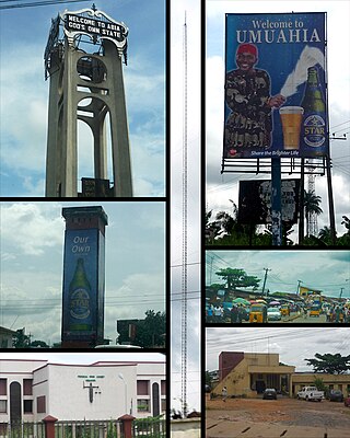
Umuahia is the capital city of Abia State in southeastern Nigeria. Umuahia is located along the rail road that lies between Port Harcourt to its south,and Enugu city to its north. Umuahia has a population of 359,230 according to the 2006 Nigerian census. Umuahia is indigenously Igbo.

The Eastern Region was an administrative region in Nigeria, dating back originally from the division of the colony Southern Nigeria in 1954. Its first capital was Calabar. The capital was later moved to Enugu and the second capital was Umuahia. The region was officially divided in 1967 into three new states, the East-Central State, Rivers State and South-Eastern State. East-Central State had its capital at Enugu, which is now part of Enugu State.
Abia State University Uturu (ABSU) is a Nigerian public university. It is one of the state owned universities in Nigeria. These state academic institutions were created to expand admissions and bring professional skills, expertise and modern research facilities close to the city and rural dwellers, and have helped talented students to obtain higher education.

Theodore Ahamefule Orji CON is a Nigerian politician who was governor of Abia State in southeast Nigeria from 2007 to 2015. He was formerly a career civil servant, and served as the Chief of Staff to Abia Governor Orji Uzor Kalu.
Nsirimo is a large community of about 5,000 people situated in Ubakala, Umuahia South Local Government in Abia state, Nigeria. It comprises autonomous community .Umumba is a community consisting of the Ibeku tribe and some other smaller tribes. It is bordered with Umuako in the west and Ubakala in the south. Its major market is Oreama market which is in the north. Umumba is not to far from Apumiri the Headquarters of Umuahia South Local Government Area.
Bende is a Local Government Area in Abia State, Nigeria with headquarters located in Bende Community. Bende Local Government Area (L.G.A) of Abia state lies on 70 30I of the Greenwich Meridian and latitude 50 30I North of the Equator. It is composed of thirteen (13) communities, namely: Alayi, Bende, Ezukwu, Igbere, Item, Itumbuzo, Nkpa, Ntalakwu, Ozuitem, Ugwueke, Umu-imenyi, Umuhu-Ezechi, and Uzuakoli.
Obowo, also spelled Obowu is a Local Government Area in Imo State, Nigeria formed during the Ibrahim Babangida administration in May 1989. It was carved out of Etiti Local Government Area with its headquarters at Isi Nweke. There are twenty-two autonomous communities in Obowo Local Government Area. Achara, Amanze, Umuariam, Umunachi, Umuagu, Ehume, Umungwa, Umulogho, Odenkwume, Okwuohia, Amuzi, Alike, Avutu, Umuosochie and Umuoke are towns in the L.G.A. Obowo is located about 45 minutes from Owerri, across the Imo River and is less than 30 minutes from the Umuahia and Ahiara in opposite directions with the Amanze seven and a half (71/2) junction and landmark in-between. It is surrounded by Ahiazu and Aboh Mbaise Local Government Areas to the north and Umuahia Abia State to the East.
Isuikwuato is a local government area in Abia State in southeastern Nigeria. The name Isu-Ikwu-Ato translates from Igbo as 'three Isu families or lineage' and refers to the three lineages descended from the Isu people, in what is now a local government area. The three brothers are Imenyi who is the eldest, Oguduasaa, his younger brother from the same mother and Isuamawo the second oldest and first from the second wife. These three major clans which also harbour various communities in each of them make up the present day Isuikwuato. It has an estimated population of over 50,000 people. Isuikwuato has natural resources such as iron ore and kaolin. Oil lines flow through Isuikwuato and there have been cases of burst pipe which have had severe effects on the local economy and environment. The major cash crops are palm oil and cassava. The soil at Isuikwuato is loose and suffers from Erosion and this left some dangerous erosion sites in the area. They lack the needed government backing to build drainages around the area to guide the flow of water without further harming the already crying soil. Blessed with hills and highlands, the town will appreciate water infrastructures because water is an important but hard resource to get in Isuikwuato. Isuikwuato is also home to Abia State University Uturu.
Ohafia is an Igbo town in the Ohafia local government area (LGA) in Abia State, Nigeria. It is an Igbo speaking region. The ancestral capital of Ohafia town is the centrally located village of Elu. Ohafia Local Government Area, is an administrative jurisdiction assigned by the Nigeria Government, which covers the entire Ohafia villages and other towns such as Abiriba and Nkporo, with its Administrative Headquarters at Ebem Ohafia.
Igbere is a suburban town in Bende local government aArea of Abia State of the South-Eastern geopolitical region Nigeria. Also popularly known and referred to as the Igbere Ebiri, the town is the core "part of Old-Bende Division of the former Eastern Nigeria". The people of Igbere, relating to, or characteristic of Igbere or its inhabitants and heritage are called Igberian.
Ikwuano is a Local Government Area of Abia State, Nigeria. Its headquarters is in Isiala Oboro. The name 'Ikwuano' etymologically indicates that there are four different ancient kingdoms that make up the community called Ikwuano. These include Oboro, Ibere, Ariam/Usaka and Oloko.

Ukwa West is a Local Government Area in Abia State, Nigeria. Its headquarters is in the town of Oke Ikpe.
Umuahia North is a Local Government Area of Abia State, Nigeria. Its headquarters are in the city of Umuahia.
Elemaga is a small farming village in Ibere, Ikwuano, Abia State, Nigeria. Elemaga is located in the center of Inyila, Isiala Ibere, Ahia Orie, Iberenta, Inyila, Itunta and Obuoru at the food belt of Ibere, about 15 km southwest of Umuahia, the Abia State capital. Elemaga is believed to be derived syntactically from the words Ele ("look"), Ma ("well") and Ga ("go") which literally means "look well before you go". Climate is tropical monsoon.
Ndoro is a town in Oboro, Ikwuano Local Government Area of Abia State, Nigeria. It is about 16 km southeast from the state capital, Umuahia and is located along the Umuahia-Ikot Ekpene Road.
Ariam Ala-Ala is a community in Ikwuano Local Government Area of Abia State, Nigeria. It is one of 15 localities of the Ariam/Usaka clan. It is located along the Umuahia-Ikot Ekpene Road and is about 27 km away from the state capital, Umuahia.
Kelechi Onuzuruike is a Nigerian politician. He is the Deputy Chief Whip of the Abia State House of Assembly. He currently represents Umuahia North state constituency in the Abia State House of Assembly.
References
- ↑ "Abia North elite endorse Kalu for Senate". The Sun, December 12, 2014
- ↑ Stephen A. Rhodes (26 May 1998). Where the Nations Meet: The Church in a Multicultural World. InterVarsity Press. pp. 119–. ISBN 978-0-8308-1936-2.
- ↑ Ikpendu C. Ononogbu (2004). Nkpa: a community in search of leadership and identity. Great AP Express Publishers. p. 1.
- ↑ Henry Kanu Offonry (1993). Royal eagle: Eze Onu Egwunwoke. New Africa Publishing Co., Ltd. p. 110.
- ↑ "Abia plans roads to link senatorial zones". News Express, By Boniface Okoro, Umuahia on 25/01/2016
- ↑ "Nigeria: Abia - Calm Returns After the Storm". AllAfrica, 6 March 2016, Emmanuel Ugwu
- ↑ "Oil/gas company partners Abia in road project". Business Day, Mar 22nd, 2016, UDOKA AGWU, UMUAHIA
- ↑ Tayo Orekoya; Tony Agbugba (2001). Local government administration in Nigeria. Pure Language Communications. p. 124.
| | This Abia state, Nigeria location article is a stub. You can help Wikipedia by expanding it. |