
Utah is a state in the Mountain West subregion of the Western United States. Utah is a landlocked U.S. state bordered to its east by Colorado, to its northeast by Wyoming, to its north by Idaho, to its south by Arizona, and to its west by Nevada. Utah also touches a corner of New Mexico in the southeast. Of the fifty U.S. states, Utah is the 13th-largest by area; with a population over three million, it is the 30th-most-populous and 11th-least-densely populated. Urban development is mostly concentrated in two areas: the Wasatch Front in the north-central part of the state, which is home to roughly two-thirds of the population and includes the capital city, Salt Lake City; and Washington County in the southwest, with more than 180,000 residents. Most of the western half of Utah lies in the Great Basin.

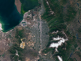
Salt Lake City is the capital and most populous city of the U.S. state of Utah, as well as the seat of Salt Lake County, the most populous county in Utah. With a population of 199,723 in 2020, the city is the core of the Salt Lake City metropolitan area, which has a population of 1,257,936. Salt Lake City is further situated within a larger metropolis known as the Salt Lake City–Ogden–Provo Combined Statistical Area, a corridor of contiguous urban and suburban development stretched along a 120-mile (190 km) segment of the Wasatch Front, comprising a population of 2,606,548, making it the 22nd largest in the nation. It is also the central core of the larger of only two major urban areas located within the Great Basin.

Wasatch County is a county in the U.S. state of Utah. As of the 2010 United States Census, the population was 23,530. Its county seat and largest city is Heber City. The county was named for a Ute Indian word meaning mountain pass or low place in the high mountains.

Brigham City is a city in Box Elder County, Utah, United States. The population was 17,899 at the 2010 census. It is the county seat of Box Elder County. It lies on the western slope of the Wellsville Mountains, a branch of the Wasatch Range at the western terminus of Box Elder Canyon. Brigham City saw most of its growth during the 1950s and 1960s, but has seen a struggling economy and stagnating growth since then. It is near the headquarters of ATK Thiokol, the company that created the solid rocket boosters for the Space Shuttle.

Murray is a city situated on the Wasatch Front in the core of Salt Lake Valley in the U.S. state of Utah. Named for territorial governor Eli Murray, it is the state's fourteenth largest city. According to the 2020 census, Murray had a population of 50,637. Murray shares borders with Taylorsville, Holladay, South Salt Lake and West Jordan, Utah. Once teeming with heavy industry, Murray's industrial sector now has little trace and has been replaced by major mercantile sectors. Known for its central location in Salt Lake County, Murray has been called the Hub of Salt Lake County. Unlike most of its neighboring communities, Murray operates its own police, fire, power, water, library, and parks and recreation departments and has its own school district. While maintaining many of its own services, Murray has one of the lowest city tax rates in the state.

Sandy is a city in the Salt Lake City metropolitan area, located in Salt Lake County, Utah, United States. The population of Sandy was 87,461 at the 2010 census, making it the sixth-largest city in Utah. The population is currently estimated to be about 96,380 according to the July 1, 2019 United States Census estimates.

Draper is a city in Salt Lake and Utah counties in the U.S. state of Utah, about 20 miles (32 km) south of Salt Lake City along the Wasatch Front. As of the 2020 census, the population is 51,017, up from 7,143 in 1990.

The Wasatch Range or Wasatch Mountains is a mountain range in the western United States that runs about 160 miles (260 km) from the Utah-Idaho border south to central Utah. It is the western edge of the greater Rocky Mountains, and the eastern edge of the Great Basin region. The northern extension of the Wasatch Range, the Bear River Mountains, extends just into Idaho, constituting all of the Wasatch Range in that state.

Federal Heights is a neighborhood in Salt Lake City, Utah. It is generally considered as the residential area to the east of Virginia Street and to the north of South Temple Street in Salt Lake City. It abuts the Wasatch Mountains to the north, and the University of Utah to the south and east. Federal Heights is one of the more affluent neighborhoods in Salt Lake City, with many of the homes in the area dating to the early 20th century.

The Wasatch Front is a metropolitan region in the north-central part of the U.S. state of Utah. It consists of a chain of contiguous cities and towns stretched along the Wasatch Range from approximately Provo in the south to Logan in the north, and containing the cities of Salt Lake City, Bountiful, and Ogden.

Capitol Hill in Salt Lake City gets its name from the Utah State Capitol prominently overlooking downtown. In addition, Capitol Hill can be considered a neighborhood of Salt Lake City.

Originally, the Salt Lake Valley was inhabited by the Shoshone, Paiute, Goshute and Ute Native American tribes. At the time of the founding of Salt Lake City the valley was within the territory of the Northwestern Shoshone, who had their seasonal camps along streams within the valley and in adjacent valleys. One of the local Shoshone tribes, the Western Goshute tribe, referred to the Great Salt Lake as Pi'a-pa, meaning "big water", or Ti'tsa-pa, meaning "bad water". The land was treated by the United States as public domain; no aboriginal title by the Northwestern Shoshone was ever recognized by the United States or extinguished by treaty with the United States. Father Silvestre Vélez de Escalante, a Spanish Franciscan missionary is considered the first European explorer in the area in 1776, but only came as far north as Utah valley (Provo), some 60 miles south of the Salt Lake City area. The first US visitor to see the Salt Lake area was John Chugg in 1824. U.S. Army officer John C. Frémont surveyed the Great Salt Lake and the Salt Lake Valley in 1843 and 1845. The Donner Party, a group of ill-fated pioneers, traveled through the Great Salt Lake Valley a year before the Mormon pioneers. This group had spent weeks traversing difficult terrain and brush, cutting a road through the Wasatch Mountains, coming through Emigration canyon into the Salt Lake Valley on August 12, 1846. This same path would be used by the vanguard company of Mormon pioneers, and for many years after that by those following them to Salt Lake.
Salt Lake Valley is a 500-square-mile (1,300 km2) valley in Salt Lake County in the north-central portion of the U.S. state of Utah. It contains Salt Lake City and many of its suburbs, notably Murray, Sandy, South Jordan, West Jordan, and West Valley City; its total population is 1,029,655 as of 2010. Brigham Young said, "this is the right place," when he and his fellow Mormon settlers moved into Utah after being driven out of several states.

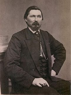
George Montgomery Scott was a U.S. politician and entrepreneur, notable for being the first non-Mormon mayor of Salt Lake City, Utah. He was a member of the Liberal Party and served as mayor of Salt Lake City from 1890 to 1892.
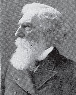
Daniel Hanmer Wells was an American apostle of The Church of Jesus Christ of Latter-day Saints and the 3rd mayor of Salt Lake City.

The History of Utah is an examination of the human history and social activity within the state of Utah located in the western United States.
State Route 171 (SR-171) is a state highway in the Salt Lake City metropolitan area in northern Utah that runs from SR-111 in Magna in the west side of the city to Interstate 215 in the city of Millcreek in the eastern part valley. In its sixteen-mile span, the route is named 3500 South and 3300 South.

Deseret Peak is the highest peak in the Stansbury Mountains with an elevation of 11,035 ft. It is located in the Deseret Peak Wilderness area west of Grantsville, Utah and east of Skull Valley Indian Reservation. It is the fourth most topographically prominent peak in the state of Utah. The site is a popular destination for hikers and backcountry skiers as the area is a contrast of the alpine wilderness with the surrounding desert basin. The trail that leads to the peak is easily accessible from Salt Lake City. The mountain offers views of the Bonneville Salt Flats, the Great Salt Lake, and the surrounding towns and mountain ranges. On a clear day, it is possible to see Mount Nebo, the highest peak in the adjacent Wasatch Mountains.
Abram Chase Hatch was an American Mormon pioneer and missionary and was a politician in Utah Territory.
Cannon & Fetzer was an American architectural firm that operated between 1909 and 1937 in Salt Lake City, Utah. Lewis T. Cannon and John Fetzer were the principal architects. A number of its works are listed on the U.S. National Register of Historic Places. For a brief time between 1910 and 1915, the firm was named Cannon, Fetzer & Hansen after partnering with Ramm Hansen. Many of their works survive and are listed on the U.S. National Register of Historic Places.
