
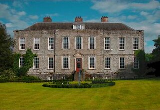
Temple Newsam, is a Tudor-Jacobean house in Leeds, West Yorkshire, England, with grounds landscaped by Capability Brown.

Failsworth is a town in Greater Manchester, England, 3.7 miles (6.0 km) northeast of Manchester and 2.9 miles (4.7 km) southwest of Oldham. The orbital M60 motorway skirts Failsworth's eastern boundary. The population at the 2011 census was 20,680.

Pontcanna is a district and community in the city of Cardiff, Wales. It is located a short distance to the west of the city centre, and its borders are approximately indicated by Western Avenue, the River Taff, Cowbridge Road East, Llandaff Road and Cardiff Road.

Wythenshawe is an area of south Manchester, England.
Thurnby Lodge is an estate in eastern Leicester, England. Roughly, it consists of the area inside the city boundary which is north of the Uppingham Road, east of the A563 outer ringroad, and south of the Scraptoft Lane. Since the core area around Thurncourt Road is a council estate with an average reputation, many, particular those around the western and southern fringe, would disassociate their area from Thurnby Lodge.
Locust Manor is a neighborhood in the New York City borough of Queens. It is bordered on the north by Baisley Boulevard to Irwin Place to Roe Road to 120th Avenue, on the east by the tracks of the Long Island Rail Road to 121st Avenue to Farmers Boulevard, on the south by North Conduit Boulevard, and on the west by Guy R. Brewer Boulevard to 137th Avenue to 173rd Street to 134th Road to Bedell Street. Nearby neighborhoods include Jamaica, South Jamaica, and Rochdale Village. Locust Manor, which was named after a 1906 residential development in the area, was formerly the location of the Jamaica Race Course, which operated from 1903 to 1959, and was torn down in 1960 in order to construct Rochdale Village.

Daisy Nook is a country park in Failsworth, Greater Manchester, England. The park runs through the Medlock Valley in an area once called Waterhouses. Waterhouses was one of three 'houses' in the Failsworth area, the other two being Millhouses and Woodhouses.
Tibbington is a residential area of Tipton, a town in the West Midlands of England. It takes its name from the original 11th-century name of Tipton – Tibbingtone.

Stock Beck is a minor river in the West Craven area of Pendle, Lancashire. It is 8.25 miles (13.27 km) long and has a catchment area of 14.41 square miles (3,731.89 ha).

Healey is part of the Metropolitan Borough of Rochdale, Greater Manchester, England. Historically part of Lancashire, it includes Shawclough, Syke and Nook Farm and the rest of the land known as Healey on the right side of Whitworth Road (A671) after Gale Street up to Healey Corner. The population of this Rochdale ward at the 2011 census was 10,411.

The A640 is a road in England which runs between Rochdale in Greater Manchester and Huddersfield in West Yorkshire.
53.1358°N 6.751667°W
The Rochdale Way is a circular 45-mile (72 km) walking route around the Metropolitan Borough of Rochdale in Greater Manchester, which takes in the best scenery and interesting buildings of the area.
The Elms is a housing estate built by the town council in the 1950s to provide social housing on the south-western edge of Ripley, Derbyshire, England. It took its name from The Elms farm whose land it was built on. The house, called The Elms, was converted into flats and the farm yard and outbuildings were used as a depot by the council until demolition around the 1970s when sheltered housing was built on the site. The houses on the estate are traditionally built red brick, mainly three and four bedroom with the occasional five bedroom.

Newland is a suburb of Kingston upon Hull, East Riding of Yorkshire, England, in the north-west of the city, a former village on the Hull to Beverley turnpike.
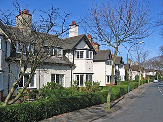
The Garden Village is an area of model village housing built in the early 1900s, in the Summergangs area of Kingston upon Hull, England, for the workers of Reckitt & Sons.
Whirlow Hall Farm is a working farm situated on Broad Elms Lane at Whirlow in the City of Sheffield, England. Since 1979 it has been the site of the Whirlow Hall Farm Trust, a registered charity which allows children and young people to visit a working farm. The site includes various Grade II listed buildings including Whirlow Farmhouse built on the site of the old Whirlow Hall. In the yard below the farmhouse is Whirlow Hall Cottage along with two ancient cruck barns and a cow shed.

The North Hull Estate is a residential area in the north of Kingston upon Hull, west of the River Hull, built by Hull Corporation in the interwar period.
Tittesworth is a civil parish in the Staffordshire Moorlands, in Staffordshire, England. It extends from the edge of the town of Leek in the south-west to Blackshaw Moor in the north-east. In the east is the village of Thorncliffe. To the west is the civil parish of Leekfrith, where the boundary is the River Churnet.To the east is the civil parish of Onecote. Tittesworth Brook runs westwards through the area from Thorncliffe, and flows into the Churnet.


