Wardleworth

Last updated

Wardleworth
WardleworthRochdaleAncientParish.png
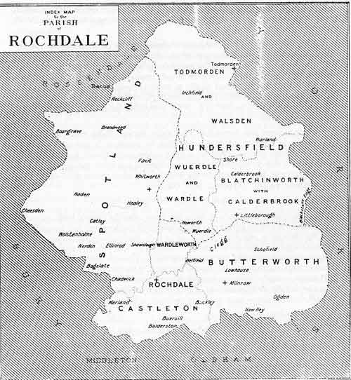
Wardleworth shown within the parish of Rochdale
Population
  18306,451
History
  Abolished1894
  Succeeded by County Borough of Rochdale
Status Township (? - 1894)
   HQ Buckley

Wardleworth was a township at the geographic centre of the Parish of Rochdale, in Salford Hundred, Lancashire, England. [1] The principal estate of the township was Buckley. Though the administrative territory has long been abolished, the name continues as a geographic reference frame for that part of Rochdale.

Wardleworth was a township that included territory to the northeast of the town of Rochdale, including the hamlets of Buckley, Crankey Shaw and Hamer Fold, [2] and, although close to the village of Wardle, Wardleworth did not contain the settlement, which was instead within the neighbouring township of Wuerdle and Wardle.

In 1830, Wardleworth was recorded to have 6,451 inhabitants. [3]

The Buckley and Entwistle families are recorded to have been the principal landowners of this township, with Buckley Hall being the seat of the estateholders for many years.

See also

  1. A vision of Butterworth Tn/CP
  2. "Index Map for the Parish of ROCHDALE". freepages.genealogy.rootsweb.com. Retrieved 30 August 2007.
  3. "Salford Hundred Ancestry, Annals and History". www.mancuniensis.info. Retrieved 30 August 2007.

53°37′39″N2°09′12″W / 53.6276°N 2.1532°W / 53.6276; -2.1532


Related Research Articles

<span class="mw-page-title-main">Rochdale</span> Town in Greater Manchester, North West England

Error: no inner hatnotes detected (help).

<span class="mw-page-title-main">Milnrow</span> Human settlement in England

Milnrow is a town within the Metropolitan Borough of Rochdale, in Greater Manchester, England. It lies on the River Beal at the foothills of the South Pennines, and forms a continuous urban area with Rochdale. It is 2 miles (3.2 km) east of Rochdale town centre, 10 miles (16.1 km) north-northeast of Manchester, and spans from Windy Hill in the east to the Rochdale Canal in the west. Milnrow is adjacent to junction 21 of the M62 motorway, and includes the village of Newhey, and hamlets at Tunshill and Ogden.

<span class="mw-page-title-main">Salford Hundred</span>

The Salford Hundred was one of the subdivisions of the historic county of Lancashire in Northern England (see:Hundred. Its name alludes to its judicial centre being the township of Salford. It was also known as the Royal Manor of Salford and the Salford wapentake.

<span class="mw-page-title-main">Middleton, Greater Manchester</span> Town in Greater Manchester, England

Middleton is a town in the Metropolitan Borough of Rochdale, Greater Manchester, England, on the River Irk 5 miles (8.0 km) southwest of Rochdale and 5 miles (8.0 km) northeast of Manchester city centre. Middleton had a population of 42,972 at the 2011 Census. It lies on the northern edge of Manchester, with Blackley to the south and Moston to the south east.

<span class="mw-page-title-main">Littleborough, Greater Manchester</span> Village in Rochdale, England

Littleborough is a village in the Metropolitan Borough of Rochdale, Greater Manchester, England, in the upper Roch Valley by the foothills of the South Pennines, 3 miles (4.8 km) northeast of Rochdale and 13 miles (20.9 km) northeast of Manchester; Milnrow and the M62 motorway are to the south, and the rural uplands of Blackstone Edge to the east. According to the 2001 census, Littleborough, and its suburbs of Calderbrook, Shore and Smithy Bridge, had a population of 13,807.

<span class="mw-page-title-main">Swinton, Greater Manchester</span> Town in Greater Manchester, England

Swinton is a town in the City of Salford in Greater Manchester, England. southwest of the River Irwell, 4 miles (6.4 km) northwest of Manchester, adjoining the town of Pendlebury and suburb of Clifton. In 2014, it had a population of 22,931.

<span class="mw-page-title-main">Rochdale (UK Parliament constituency)</span> Parliamentary constituency in the United Kingdom, 1832 onwards

Rochdale is a seat represented in the House of Commons of the UK Parliament. It has elected one Member of Parliament (MP) since its 1832 creation.

<span class="mw-page-title-main">Anglican Diocese of Manchester</span> Diocese of the Church of England

The Diocese of Manchester is a Church of England diocese in the Province of York, England. Based in the city of Manchester, the diocese covers much of the county of Greater Manchester and small areas of the counties of Lancashire and Cheshire.

<span class="mw-page-title-main">Wardle, Greater Manchester</span> Human settlement in England

Wardle is a village near Littleborough within the Metropolitan Borough of Rochdale, in Greater Manchester, England. It lies amongst the foothills of the South Pennines, 1.8 miles (2.9 km) east-southeast of Whitworth, 2.5 miles (4 km) north-northwest of Rochdale and 12 miles (19 km) north-northeast of the city of Manchester.

Wardle Academy is a coeducational secondary school with academy status, located in Wardle, Greater Manchester, England. It was founded in September 1977.

<span class="mw-page-title-main">Whitworth, Lancashire</span> Human settlement in England

Whitworth is a town and civil parish in Rossendale, Lancashire, England, amongst the foothills of the Pennines between Bacup, to the north, and Rochdale, to the south. It had a population of 7,500 at the 2011 Census.

Salford Royal NHS Foundation Trust operated Salford Royal Hospital in Greater Manchester until 2017. Its chief executive is Dr Owen Williams.

Hundersfield was a manor, parish and, from 1746, township, within the parish of Rochdale, in the hundred of Salford, England. It straddled the historic county boundary between Lancashire and the West Riding of Yorkshire. There are written references to the parish dating back to 1202.

Buckley Hall was a historic house in Buckley near Rochdale, Lancashire, England which was the home of the Buckley and later Entwistle family. The building was a Catholic boys' orphanage from 1888 to 1947, when it was demolished; Buckley Hall Prison now occupies the site.

<span class="mw-page-title-main">Butterworth (ancient township)</span> Ancient township in England

Butterworth was a township occupying the southeastern part of the parish of Rochdale, in the hundred of Salford, Lancashire, England. It encompassed 12.1 square miles (31 km2) of land in the South Pennines which spanned the settlements of Belfield, Bleaked-gate-cum-Roughbank, Butterworth Hall, Clegg, Haughs, Hollingworth, Kitcliffe, Lowhouse, Milnrow, Newhey, Ogden, Rakewood, Smithy Bridge, Tunshill and Wildhouse. It extended to the borders of Crompton to the south, and to the highest points of Bleakedgate Moor and Clegg Moor, up to the ridge of Blackstone Edge, to the east, where its boundary was the old county boundary between Lancashire and Yorkshire.

<span class="mw-page-title-main">Buckley, Greater Manchester</span> Human settlement in England

Buckley is a suburban area within the Metropolitan Borough of Rochdale, in Greater Manchester, England. It lies at the northern fringe of Rochdale, along the course of Buckley Brook, "upon an eminence of ground" by the South Pennines. It is 1.2 miles (1.9 km) south-southwest of the village of Wardle and 1.3 miles (2.1 km) north-northeast of Rochdale's town centre. Buckley spans a watercourse, a prison, farmland and residential properties.

<span class="mw-page-title-main">Rochdale (ancient parish)</span>

Rochdale was an ecclesiastical parish of early-medieval origin in northern England, administered from the Church of St Chad, Rochdale. At its zenith, it occupied 58,620 acres (237 km2) of land amongst the South Pennines, and straddled the historic county boundary between Lancashire and the West Riding of Yorkshire. To the north and north-west was the parish of Whalley; to the southwest was the parish of Bury; to the south was Middleton and Prestwich-cum-Oldham.

<span class="mw-page-title-main">Geography of Greater Manchester</span>

The geography of Greater Manchester is dominated by one of the United Kingdom's largest metropolitan areas, and in this capacity the landlocked metropolitan county constitutes one of the most urbanised and densely populated areas of the country. There is a mix of high density urban areas, suburbs, semi-rural and rural locations in Greater Manchester, but overwhelmingly the land use in the county is urban.

<span class="mw-page-title-main">Wardleworth railway station</span> Former railway station in England

Wardleworth railway station served the township of Wardleworth in Rochdale, in the Metropolitan Borough of Rochdale in Greater Manchester, England, from 1870 until closure in 1947. It was on the Facit Branch between Rochdale and Facit, which was extended to Bacup in 1881. The station was quite well placed for Rochdale town centre and so, in addition to the branch trains, a few other services from Manchester terminated here. Between here and Rochdale station was the Roch Valley Viaduct, now demolished.

James Butterworth also known as Paul Bobbin was an English author, poet, antiquarian and topographer of Manchester and the surrounding area.