Nor'Wester Mountains

Last updated
Nor'Wester Mountains

Neebing ON.JPG

The Nor'Westers seen from Neebing Township
Highest point
Peak Mount McKay
Elevation 483 m (1,585 ft)
Coordinates 48°20′43″N89°17′8″W / 48.34528°N 89.28556°W / 48.34528; -89.28556 Coordinates: 48°20′43″N89°17′8″W / 48.34528°N 89.28556°W / 48.34528; -89.28556
Geography
Country Canada
Province Ontario
Mount McKay Mount McKay Thunder Bay.jpg
Mount McKay

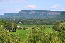
The Nor'Wester Mountains are a group of mountains immediately south of Thunder Bay, Ontario, Canada, located on the southern limits of the City of Thunder Bay and south of the Kaministiquia River. [1] :32,33 Mount McKay is the highest, most northern and best known of these mountains. Other prominent peaks include Godfrey, Hurlburt, Johnson, Matchett, McRae, McQuaig, Rose, and Squaretop.

Mountain A large landform that rises fairly steeply above the surrounding land over a limited area

A mountain is a large landform that rises above the surrounding land in a limited area, usually in the form of a peak. A mountain is generally steeper than a hill. Mountains are formed through tectonic forces or volcanism. These forces can locally raise the surface of the earth. Mountains erode slowly through the action of rivers, weather conditions, and glaciers. A few mountains are isolated summits, but most occur in huge mountain ranges.

Thunder Bay City in Ontario, Canada

Thunder Bay is a city in, and the seat of, Thunder Bay District, Ontario, Canada. It is the most populous municipality in Northwestern Ontario with a population of 107,909 as of the Canada 2016 Census, and the second most populous in Northern Ontario after Greater Sudbury. Located on Lake Superior, the census metropolitan area of Thunder Bay has a population of 121,621, and consists of the city of Thunder Bay, the municipalities of Oliver Paipoonge and Neebing, the townships of Shuniah, Conmee, O'Connor, and Gillies, and the Fort William First Nation.

Ontario Province of Canada

Ontario is one of the 13 provinces and territories of Canada and is located in east-central Canada. It is Canada's most populous province accounting for 38.3 percent of the country's population, and is the second-largest province in total area. Ontario is fourth-largest jurisdiction in total area when the territories of the Northwest Territories and Nunavut are included. It is home to the nation's capital city, Ottawa, and the nation's most populous city, Toronto, which is also Ontario's provincial capital.

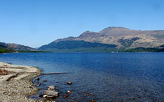
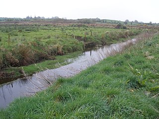
Loch Lomond, 287 m (942 ft) above sea level, collects most of the runoff within the Nor’Wester Mountains; Loch Lomond is drained by the Lomond River. [1] :5 A few square kilometers of mountain slope south of Mount McKay are drained by Whiskeyjack Creek. [1] :5

Loch Lomond (Thunder Bay District) lake in Thunder Bay District, Ontario, Canada

Loch Lomond is a large spring-fed lake located 102 metres (335 ft) above Lake Superior, 6 kilometres (3.7 mi) south of the city of Thunder Bay, Ontario, Canada. It is located in behind Mount McKay, in the Fort William First Nation and Neebing Municipality. Loch Lomond is considered to be a deep oligotrophic lake. The natural re-charge level of Loch Lomond from underground spring water is estimated at 57,100 m3 (12,600,000 imp gal) per day.

Related Research Articles

Lakehead University in Thunder Bay, and Orillia, Ontario, Canada

Lakehead University is a public research university with campuses in Thunder Bay and Orillia, Ontario, Canada. Lakehead University, shortened to 'Lakehead U', or 'LU', is non-denominational and provincially supported. It has undergraduate programs, graduate programs, the Bora Laskin Faculty of Law, the only internationally accredited (AACSB) business school in northern Ontario, and is home to the western campus of the Northern Ontario School of Medicine.

Loch Lomond and The Trossachs National Park national park

Loch Lomond and The Trossachs National Park is a national park in Scotland centred on Loch Lomond and the hills and glens of the Trossachs, along with several other ranges of hills. It was the first of the two national parks established by the Scottish Parliament in 2002, the second being the Cairngorms National Park. The park consists of many mountains and lochs, and the principal attractions are scenery, walking, and wildlife.

Ben Lomond Scottish mountain

Ben Lomond, 974 metres (3,196 ft), is a mountain in the Scottish Highlands. Situated on the eastern shore of Loch Lomond, it is the most southerly of the Munros. Ben Lomond lies within the Ben Lomond National Memorial Park and the Loch Lomond and The Trossachs National Park, property of the National Trust for Scotland.

Ontario Highway 61 highway in Ontario

King's Highway 61, commonly referred to as Highway 61 and historically known as the Scott Highway, is a provincially maintained highway in the Canadian province of Ontario. The 61-kilometre (38 mi) route connects the Pigeon River Bridge, where it crosses into the United States and becomes Minnesota State Highway 61, with a junction at Highway 11, Highway 17 and the Harbour Expressway in Thunder Bay. The highway forms part of the Lake Superior Circle Tour.

The Lakehead District School Board oversees all secular English-language public schools in the Thunder Bay CMA and the townships of Gorham and Ware in Ontario, Canada. It administers education at 22 elementary schools, 4 secondary schools and an adult education centre.

Mount McKay mountain in Canada

Mount McKay is a mafic sill located south of Thunder Bay, Ontario, Canada, on the Indian Reserve of the Fort William First Nation. It is the highest, most northern and best known of the Nor'Wester Mountains. It formed during a period of magmatic activity associated with the large Midcontinent Rift System about 1,100 million years ago.

King's Highway 130, commonly known as Highway 130, is a provincially maintained highway in the Canadian province of Ontario. It begins at a junction with Highway 61 and travels 15.4 km (9.6 mi) north-west to the Trans-Canada Highway, Highway 11 and Highway 17, west of Thunder Bay. Highway 130 is a short connecting highway, and passes entirely through the outskirts of Thunder Bay, connecting several minor communities and providing a shortcut for traffic travelling from the south to the west or vice versa. The speed limit along the highway is 80 km/h (50 mph); it is patrolled by the Ontario Provincial Police.

An Caisteal mountain in the United Kingdom

An Caisteal is a Scottish mountain situated six kilometres south of the village of Crianlarich in the Stirling Council area.

Fort William First Nation Indian reserve in Ontario, Canada

Fort William First Nation is an Ojibwa First Nation reserve in Ontario, Canada. The administrative headquarters for this band government is south of Thunder Bay. As of January 2008, the First Nation had a registered population of 1,798 people, of which their on-Reserve population was 832 people.

Ben Oss mountain in the United Kingdom

Ben Oss is a Scottish mountain situated in the Stirling Council area, six kilometres south west of the village of Tyndrum within the Loch Lomond and the Trossachs National Park.

Kitimat River river in Canada

The Kitimat River is a river in the Canadian province of British Columbia. It originates in the Kitimat Ranges, near the sources of the Dala River, Kemano River, Atna River, and Clore River. It flows in a curve north, then west, then south, emptying into Kitimat Arm at the head of Douglas Channel, at the town of Kitimat.

River Robe (Ireland) river in Ireland

The River Robe is a river in County Mayo, Ireland. It rises near Ballyhaunis, then flows generally west for 64 kilometres (40 mi), where it drains into Lough Mask.

Maupertuis Bay bight in Australia

Maupertuis Bay is a bay in the Australian state of South Australia located on the south-west coastline of Kangaroo Island.

Loch Lomond National Nature Reserve

Loch Lomond National Nature Reserve (NNR) encompasses 430 hectares of land at the southeastern part of Loch Lomond in the council areas of Stirling and West Dunbartonshire, in Scotland. It covers the islands of Inchcailloch, Clairinsh, Torrinch, Creinch and Aber Isle, alongside areas of woodland and wetlands to either side of the mouth of the Endrick Water. Scottish Natural Heritage (SNH) owns two parts of the reserve - the island of Inchcailloch and part of Gartfairn Wood - and the rest is privately owned. The reserve is managed by a partnership consisting of SNH, the Royal Society for the Protection of Birds (RSPB) and the Loch Lomond and The Trossachs National Park, along with the owners and tenants of the land under agreements. Within this framework SNH directly manage the islands of Clairinsh, Inchcailloch, Torrinch and Creinch, and land to the north of the Endrick Water. The RSPB manages the area to the south of the Endrick Water, and the National Park manages visitor facilities on Inchcailloch.

Loch Rannoch and Glen Lyon National Scenic Area

The Loch Rannoch and Glen Lyon National Scenic Area is a national scenic area (NSA) covering the area surrounding Loch Rannoch, Glen Lyon, and the Ben Lawers ranges of mountains in Scotland. It is one of 40 such areas in Scotland, which are defined so as to identify areas of exceptional scenery and to ensure its protection from inappropriate development by restricting certain forms of development. The Loch Rannoch and Glen Lyon NSA covers 48,625 ha, most of which lies in the council area of Perth and Kinross, with a small portion lying in Stirling.

References

  1. 1 2 3 Watershed Characterization Report Lakehead Source Protection Area (PDF) (Report). Source Water ProtectionLakehead Region. March 2008. Retrieved June 14, 2010.