Nord, Greenland

Last updated
Nord
Station Nord
Military outpost
Nord-geod0945.jpg
Station Nord in 1967
Greenland edcp relief location map.jpg
Red pog.svg
Nord
Nord, Greenland
Coordinates: 81°43′00″N17°47′57″W / 81.71667°N 17.79917°W / 81.71667; -17.79917
View of the station and the surrounding landscape. Nord, Greenland.jpg
View of the station and the surrounding landscape.

Station Nord is a military and scientific station in northeastern Greenland 1700 km north of the Arctic Circle at 81°43'N, 17°47'W. ICAO: BGNO.

Greenland Autonomous country within the Kingdom of Denmark

Greenland is an autonomous constituent country of the Kingdom of Denmark between the Arctic and Atlantic oceans, east of the Canadian Arctic Archipelago. Though physiographically a part of the continent of North America, Greenland has been politically and culturally associated with Europe for more than a millennium. The majority of its residents are Inuit, whose ancestors began migrating from the Canadian mainland in the 13th century, gradually settling across the island.

Arctic Circle Boundary of the Arctic

The Arctic Circle is one of the two polar circles and the most northerly of the five major circles of latitude as shown on maps of Earth. It marks the northernmost point at which the centre of the noon sun is just visible on the December solstice and the southernmost point at which the centre of the midnight sun is just visible on the June solstice. The region north of this circle is known as the Arctic, and the zone just to the south is called the Northern Temperate Zone.

ICAO airport code four-letter code designating many airports around the world

The ICAOairport code or location indicator is a four-letter code designating aerodromes around the world. These codes, as defined by the International Civil Aviation Organization and published in ICAO Document 7910: Location Indicators, are used by air traffic control and airline operations such as flight planning.

Contents

It is about 924 km (574 mi) from the geographic North Pole, on Prinsesse Ingeborg Halvø (Princess Ingeborg Peninsula) in northern Kronprins Christian Land, making it the second northernmost permanent settlement and base of the Northeast Greenland National Park and of Greenland as a whole (two stations in Peary Land further north, Brønlundhus and Kap Harald Moltke, are not permanently occupied).

North Pole Northern point where the Earths axis of rotation intersects its surface

The North Pole, also known as the Geographic North Pole or Terrestrial North Pole, is defined as the point in the Northern Hemisphere where the Earth's axis of rotation meets its surface.

Northeast Greenland National Park national park

Northeast Greenland National Park is the world's largest national park and the 9th largest protected land area. Established in 1974 and expanded to its present size in 1988, it protects 972,000 km2 (375,000 sq mi) of the interior and northeastern coast of Greenland and is bigger than all but twenty-nine countries in the world. It was the first national park to be created in the Kingdom of Denmark and remains Greenland's only national park.

Peary Land peninsula

Peary Land is a peninsula in northern Greenland, extending into the Arctic Ocean. It reaches from Victoria Fjord in the west to Independence Fjord in the south and southeast, and to the Arctic Ocean in the north, with Cape Morris Jesup, the northernmost point of Greenland's mainland, and Cape Bridgman in the northeast.

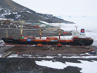
The Danish Defense Command base is staffed by five Danish non-commissioned officers on a 26-month tour of duty; accommodation is also available for over twenty scientists and other personnel during the summer months. The station has about 35 buildings. It is not accessible by ship; ice conditions would permit a passage only every five to ten years. The name Nord simply means "north" in Danish. Winter darkness extends from 15 October to 28 February.

Denmark constitutional monarchy in Europe

Denmark, officially the Kingdom of Denmark, is a Nordic country and the southernmost of the Scandinavian nations. Denmark lies southwest of Sweden and south of Norway, and is bordered to the south by Germany. The Kingdom of Denmark also comprises two autonomous constituent countries in the North Atlantic Ocean: the Faroe Islands and Greenland. Denmark proper consists of a peninsula, Jutland, and an archipelago of 443 named islands, with the largest being Zealand, Funen and the North Jutlandic Island. The islands are characterised by flat, arable land and sandy coasts, low elevation and a temperate climate. Denmark has a total area of 42,924 km2 (16,573 sq mi), land area of 42,394 km2 (16,368 sq mi), and the total area including Greenland and the Faroe Islands is 2,210,579 km2 (853,509 sq mi), and a population of 5.8 million.

Non-commissioned officer Military officer without a commission

A non-commissioned officer (NCO) is a military officer who has not earned a commission. Non-commissioned officers usually obtain their position of authority by promotion through the enlisted ranks. In contrast, commissioned officers hold higher ranks than NCOs, have more legal responsibilities, are paid more, and often have more non-military training such as a university diploma. Commissioned officers usually earn their commissions without having risen through the enlisted ranks.

Danish language North Germanic language spoken in Denmark

Danish is a North Germanic language spoken by around six million people, principally in Denmark and in the region of Southern Schleswig in northern Germany, where it has minority language status. Also, minor Danish-speaking communities are found in Norway, Sweden, Spain, the United States, Canada, Brazil, and Argentina. Due to immigration and language shift in urban areas, around 15–20% of the population of Greenland speak Danish as their first language.

History

Joint U.S.–Danish Period

In June 1950, the United States Weather Bureau first developed plans for a joint weather station in Northeast Greenland to supplement the joint weather stations being built with Canada in the high Arctic. At that time, Thule was itself a joint Danish-American weather station. The next year, in conjunction with the construction of Thule Air Base, Norwegian-born United States Air Force Colonel Bernt Balchen (who was the driving force in the American Arctic efforts) proposed a major air base in Northeast Greenland, useful for radar coverage, navigation aids, search-and-rescue, and recovery of heavy bombers returning from the USSR. Two 10,000 foot runways were contemplated. After consultations with Denmark, a weather station was operational at Nord by 1 May 1952, and a U.S.-built landing strip was available by July of that year. At that time, American interest was still focused on the possibility of a major airfield either near Nord or in Peary Land.

Qaanaaq Place in Greenland, Kingdom of Denmark

Qaanaaq, formerly and still popularly known as Thule or New Thule, is the main town in the northern part of the Avannaata municipality in northwestern Greenland. It is one of the northernmost towns in the world. The inhabitants of Qaanaaq speak Kalaallisut and Danish, and many also speak the Inuktun language. The town has a population of 656 as of 2013.

Thule Air Base US air base in Thule, Greenland

Thule Air Base, or Thule Air Base/Pituffik Airport, is the United States Air Force's northernmost base, located 1,207 km (750 mi) north of the Arctic Circle and 1,524 km (947 mi) from the North Pole on the northwest coast of the island of Greenland.

United States Air Force Air and space warfare branch of the United States Armed Forces

The United States Air Force (USAF) is the aerial and space warfare service branch of the United States Armed Forces. It is one of the five branches of the United States Armed Forces, and one of the seven American uniformed services. Initially formed as a part of the United States Army on 1 August 1907, the USAF was established as a separate branch of the U.S. Armed Forces on 18 September 1947 with the passing of the National Security Act of 1947. It is the youngest branch of the U.S. Armed Forces, and the fourth in order of precedence. The USAF is the largest and most technologically advanced air force in the world. The Air Force articulates its core missions as air and space superiority, global integrated intelligence, surveillance, and reconnaissance, rapid global mobility, global strike, and command and control.

By February 1953, the United States Air Force abandoned the air base plans and settled on a minor role for the airstrip at Nord. During that summer, an expansion of the gravel strip was carried out, a team of 41 Danes was sent to construct facilities, and the finished weather station was in operation on 1 October. The major reason for the reduction in the United States Air Force's plans was that resupply of the station was difficult and expensive. Permanent polar ice prevents supply by sea, and attempts to move heavy supplies by trans-icecap convoys from Camp TUTO were problematic. In practice, everything had to be flown in from Thule. While this was initially a United States Air Force task, it later devolved on the Royal Danish Air Force, which flew C-130s from Thule to Nord in biannual operations codenamed Brilliant Ice. (Today resupply is done by commercial charter.)

Camp TUTO

Camp TUTO was a major U.S. Army operated research camp at the foot of the Greenland ice cap, 18 miles (29 km) east of Thule Air Base. It operated from 1954 to 1966, with revisits for follow-up research.

Royal Danish Air Force Air warfare branch of Denmarks armed forces

The Royal Danish Air Force (RDAF) is the aerial warfare force of Denmark and one of the four branches of the Danish Defence. Initially being components of the Army and the Navy, it was made a separate service in 1950. It main purpose is to serve as enforcer of Danish airspace and to provide air support to Danish group troops on the battlefield.

Another factor was Danish sensitivity to U.S. activities. It was very important for the Danish government to preempt a permanent U.S. presence, and for that reason Denmark assumed responsibility for Nord's operation and refused an American offer for a lease on the station. The understanding, codified by Memorandum of Understanding in 1954, was that Nord would be available to U.S. forces as needed; however, later proposals (1957) to establish a major electronic intelligence base there were shifted to Canadian Forces Station Alert. Nord did serve as an emergency recovery site for American bombers in the 1950s, and for the occasional civilian aircraft in trouble. A U.S. satellite tracking station also operated there.

In 1968, Nord reportedly had a staff of 30 men, 25 buildings, and seven antennas. Routine communications was by radiotelegraphy to Angmagssalik. By the time of the end of the United States' responsibilities, Nord had a 6,200-foot (1,900 m) runway (elevation 80), a non-directional beacon, a meteorological observatory for synoptic and radiosonde observations, and a seismic station.

Danish Period

Station Nord in 1966 Station Nord geod0450.jpg
Station Nord in 1966
Atmospheric measurements in the station Atmospheric measurements in far north.jpg
Atmospheric measurements in the station

The original station was built by "Grønlands Televæsen" for the United States during the period of 1952 to 1956 as a weather and telecommunications site with a runway, International Civil Aviation Organization code BGMI. From the perspective of Denmark, Nord was meteorologically needed as the only weather station within hundreds of miles, and also as a resupply base for the Sirius Patrol, a dog-sledge patrol that replaced the improvised wartime sledge patrol in Northeast Greenland. The construction of Station Nord was undertaken by Danish construction companies and financed by the Danish government, with the United States contributing to the transportation of equipment from the Thule Air Base and paying subsidies to maintain the operation of the station. [1] Some of the equipment originally supplied by the United States Air Force is still in use. Until its closure in 1972, it was run as a civilian base by the Greenland Technical Organisation.

When Denmark requested funds for repairs to the runway in 1964, the United States Department of State advised that Nord was no longer essential, and that new cost arrangements would have to be made; however, the Danish agencies could not agree on who should bear the costs. In April 1971, the United States Air Force announced it would cease sending goods and fuel from Thule to Station Nord. [1] Without support from the United States, the government of Denmark decided to close the station as the relevant agencies considered it expensive to run. [1]

After the closure in late June 1972, many scientists and military officers protested and demanded that it be reopened. [1] Station Nord was important to the Royal Danish Army and the Royal Danish Air Force as a military base, enabling flights to the northern part of the National Park and support of the Sirius Patrol. Civilian scientific activities in the area were also gradually increasing.

In 1974, the Defence Command submitted plans to build a patrol station and a landing strip. Reconnaissance began in March 1974 by the air force and helicopters from "Grønlandsfly" and cabins for the sledge patrol began to be built and patrol depots restocked. [1]

With the establishment of a new weather station and the base now rebuilt, the Danish Defense Command reopened Nord in August 1975. Nord was reopened as a military base for a trial period. The station was recognized as important as a gateway to otherwise inaccessible portions of northern Greenland and was made permanent. [1]

Today the operation of the station is under the responsibility of the Joint Arctic Command (Arktisk Kommando), but is manned on a daily basis with personnel from the three services and five volunteers are stationed there 26 months at a time with a 3–5 weeks leave period in the middle. [1] The landing strip is kept open for approximately 300 days a year and is maintained with two large snow blowers and two snow plows. [1]

Climate

Nord features a very cold polar tundra climate with average temperatures just a few degrees above freezing in the midst of the short summer.

Climate data for Nord
MonthJanFebMarAprMayJunJulAugSepOctNovDecYear
Record high °C (°F)−5
(23)
−5
(23)
−2
(28)
2
(36)
6
(43)
10
(50)
14
(57)
13
(55)
5
(41)
1
(34)
1
(34)
2
(36)
14
(57)
Average high °C (°F)−27
(−17)
−26
(−15)
−27
(−17)
−18
(0)
−6
(21)
2
(36)
6
(43)
4
(39)
−6
(21)
−18
(0)
−22
(−8)
−24
(−11)
−13.5
(7.7)
Average low °C (°F)−32
(−26)
−32
(−26)
−33
(−27)
−23
(−9)
−12
(10)
−1
(30)
1
(34)
1
(34)
−10
(14)
−21
(−6)
−27
(−17)
−29
(−20)
−18.2
(−0.8)
Record low °C (°F)−51
(−60)
−47
(−53)
−46
(−51)
−37
(−35)
−24
(−11)
−10
(14)
−2
(28)
−13
(9)
−30
(−22)
−32
(−26)
−45
(−49)
−42
(−44)
−51
(−60)
Source: Weatherbase [2]

See also

Related Research Articles

Knud Rasmussen Danish explorer and anthropologist

Knud Johan Victor Rasmussen was a Greenlandic–Danish polar explorer and anthropologist. He has been called the "father of Eskimology" and was the first European to cross the Northwest Passage via dog sled. He remains well known in Greenland, Denmark and among Canadian Inuit.

The Sirius Dog Sled Patrol, known informally as Siriuspatruljen and formerly known as North-East Greenland Sledge Patrol and Resolute Dog Sled Patrol, is an elite Danish naval unit. It conducts long-range reconnaissance patrolling, and enforces Danish sovereignty in the Arctic wilderness of northern and eastern Greenland, an area that includes the largest national park in the world. Patrolling is usually done in pairs, sometimes for four months and often without additional human contact.

Danmarkshavn human settlement

Danmarkshavn is a small weather station located in Dove Bay, on the southern shore of the Germania Land Peninsula, in Northeast Greenland National Park, Greenland.

Greenland in World War II History of Greenland from 1940 to 1945.

The fall of Denmark in April 1940 left the Danish colony of Greenland an unoccupied territory of an occupied nation, under threat of seizure by the United Kingdom or Canada. To forestall this, the United States acted to guarantee Greenland's position. However, with the entrance of the United States into the war in December 1941, Greenland became a combatant.

Sondrestrom Air Base

Sondrestrom Air Base, originally Bluie West-8, was a U.S. air base in central Greenland. The site is located 60 mi (97 km) north of the Arctic Circle and 90 mi (140 km) from the northeast end of Kangerlussuaq Fjord, formerly known by its Danish name Søndre Strømfjord. The base is approximately 11 mi (18 km) west-northwest of Ravneklippen and 80 mi (130 km) east of Sisimiut.

Clavering Island island

Clavering Island is a large island in eastern Greenland off Gael Hamkes Bay, to the south of Wollaston Foreland.

MV <i>American Tern</i> (T-AK-4729)

MV American Tern (T-AK-4729) is a container ship managed by APL Maritime, Ltd. Formerly the Liberian-flagged MV Kariba, the vessel was renamed American Tern under the United States flag in 2002. Since then, the American Tern has been chartered by the United States Navy Military Sealift Command. She was contracted through 2010 to make resupply voyages to McMurdo Station in Antarctica and Thule Air Base in Greenland. The vessel is named after the Tern, a type of bird that makes annual migrations from the Arctic to the Antarctic.

Northeast Air Command 1941-1957 United States Air Force geographic command responsible for Greenland, Labrador, and Newfoundland

The Northeast Air Command (NEAC) was a short-lived organization in the United States Air Force tasked with the operation and defense of air bases in Greenland, Labrador and Newfoundland. It was formed in 1950 from the facilities of the United States established during World War II in Northeast Canada, Newfoundland and Greenland. It was discontinued in 1957.

Fletchers Ice Island A thick, tabular iceberg discovered by U.S. Air Force Colonel Joseph O. Fletcher, used as a manned scientific station in the Arctic for several years

Fletcher's Ice Island or T-3 was an iceberg discovered by U.S. Air Force Colonel Joseph O. Fletcher. Between 1952 and 1978 it was used as a manned scientific drift station that included huts, a power plant, and a runway for wheeled aircraft. The iceberg was a thick tabular sheet of glacial ice that drifted throughout the central Arctic Ocean in a clockwise direction. First inhabited in 1952 as an arctic weather report station, it was abandoned in 1954 but reinhabited on two subsequent occasions. The station was inhabited mainly by scientists along with a few military crewmen and was resupplied during its existence primarily by military planes operating from Barrow, Alaska. The iceberg was later occupied by the Naval Arctic Research Laboratory, and served as a base of operations for the Navy's arctic research projects such as sea bottom and ocean swell studies, seismographic activities, meteorological studies and other classified projects under the direction of the Department of Defense. Before the era of satellites, the research station on T-3 had been a valuable site for measurements of the atmosphere in the Arctic.

Thule Air Station

Thule Air Station is a closed United States Air Force General Surveillance Radar station. It is located 9.2 miles (14.8 km) south of Thule Air Base, Greenland. It was closed in 1965.

Bluie East Two was a minor United States Army Air Forces (USAAF) airfield at Ikateq, East Greenland. It was operational from 1942 to 1947.

Task Force 80, abbreviated as TF-80, has been the designation of several U.S. Navy task forces, with its current use associated with the United States Fleet Forces Command headquartered at Naval Station Norfolk, Virginia.

Greenland Patrol United States Coast Guard operation during World War II

The Greenland Patrol was a United States Coast Guard operation during World War II. The patrol was formed to support the U.S. Army building aerodrome facilities in Greenland for ferrying aircraft to the British Isles, and to defend Greenland with special attention to preventing German operations in the northeast. Coast Guard cutters were assisted by aircraft and dog sled teams patrolling the Greenland coast for Axis military activities. The patrol escorted Allied shipping to and from Greenland, built navigation and communication facilities, and provided rescue and weather ship services in the area from 1941 through 1945.

King Frederick VIII Land Region in Greenland

King Frederick VIII Land is a major geographic division of northeastern Greenland. It extends above the Arctic Circle from 76°N to 81°N in a N/S direction along the coast of the Greenland Sea.

Operation "Northern Falcon is a joint Ukrainian-Danish operation for the transportation of fuel from the US Air Force "Thule" to the Danish Polar Station "Nord" by the military transport aircraft IL-76MD of the Air Force of the Armed Forces of Ukraine. It has been conducted annually since 2009.

References

  1. 1 2 3 4 5 6 7 8 Eastgreenland.com Archived 30 April 2009 at the Wayback Machine .
  2. "Weatherbase: Weather For Nord, Greenland". Weatherbase. 2011. Retrieved on November 23, 2011.

Bibliography

Coordinates: 81°43′N17°47′W / 81.717°N 17.783°W / 81.717; -17.783