The geography of France consists of a terrain that is mostly flat plains or gently rolling hills in the north and west and mountainous in the south and the east.
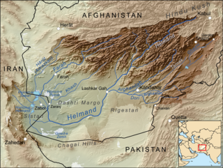
The Helmand River is the longest river in Afghanistan and the primary watershed for the endorheic Sistan Basin. This river is not the Sarasvati of the Rig Veda as some assume.

Cuneo (Italian) or Coni is a province in the southwest of the Piedmont region of Italy. To the west it borders on the French region of Provence-Alpes-Côte d'Azur. To the north it borders with the Metropolitan City of Turin. To the east it borders with the province of Asti. To the south it borders with the Ligurian provinces of Savona and Imperia. It is also known as La Provincia Granda, Piedmontese for "The Big Province", because it is the fourth largest province in Italy and the largest one in Piedmont. Briga Marittima and Tenda were part of this province before cession to France in 1947.
Rutja is a village in Haljala Parish, Lääne-Viru County, northern Estonia. It is located on the coast of the Bay of Finland and on the western shore of the Selja river. It neighbours Karepa in the east.

Jaren is the administrative centre of Gran municipality, Norway. Together with Brandbu it forms an urban area with a population of 4,423.
German submarine U-1302 was a Type VIIC/41 U-boat of Nazi Germany's Kriegsmarine for service in World War II. She was commissioned on 25 May 1944.

German submarine U-383 was a Type VIIC U-boat of Nazi Germany's Kriegsmarine during World War II.

Salinillas de Bureba is a municipality and town located in the province of Burgos, Castile and León, Spain. According to the 2014 census (INE), the municipality has a population of 51 inhabitants.
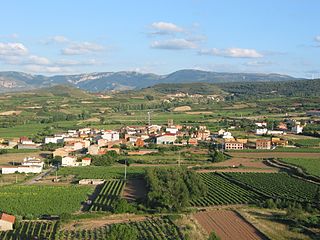
Medrano is a municipality in La Rioja, Spain. It is situated 17 km from the capital Logroño. There are 188 inhabitants and it covers 7.46 km².

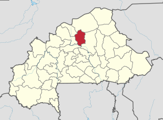
Tiéfora is a department or commune of Comoé Province in south-western Burkina Faso. Its capital lies at the town of Tiéfora. According to the 1996 census the department has a total population of 35,894.

Olari is a commune in Arad County, Romania, is situated on the Aradului Plateau, on the Morilor Ditch, on the left bank of the Crişul Alb River. Its surface occupies 4767 ha. It is composed of two villages, Olari and Sintea Mică (Szineke).

Ruda Żurawiecka is a village in the administrative district of Gmina Lubycza Królewska, within Tomaszów Lubelski County, Lublin Voivodeship, in eastern Poland, close to the border with Ukraine. It lies approximately 13 kilometres (8 mi) south-east of Tomaszów Lubelski and 119 km (74 mi) south-east of the regional capital Lublin.
Ülgüc is a village and municipality in the Agsu Rayon of Azerbaijan. It has a population of 515.
Kawempe Division is one of the five divisions that comprise the city of Kampala, Uganda.
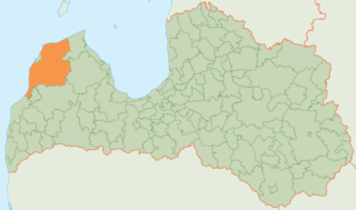
Ventspils Municipality is a municipality in Courland, Latvia. The municipality was formed in 2009 by merging Piltene town, Ance Parish, Jūrkalne Parish, Piltene rural community, Pope Parish, Puze Parish, Tārgale Parish, Ugāle Parish, Usma Parish, Užava Parish, Vārve Parish, Ziras Parish and Zlēkas Parish. It is administered from Ventspils city, which is not included within its limits.
Genionys is a village in Varėna district municipality, in Alytus County, in southeastern Lithuania. According to the 2001 census, the village has a population of 30 people.
Henriksen Buttress is a prominent rock buttress, 1,970 metres (6,460 ft) high, standing 2 nautical miles (4 km) southeast of Mount Sugartop in the central part of the Allardyce Range of South Georgia. It was surveyed by the South Georgia Survey in the period 1951–57, and was named by the UK Antarctic Place-Names Committee for Henrik N. Henriksen who, in 1909, built the South Georgia Whaling Company station at Leith Harbour, and was manager there from 1909 until 1920.
German submarine U-622 was a Type VIIC U-boat built for Nazi Germany's Kriegsmarine for service during World War II. She was laid down on 1 July 1941 by Blohm & Voss, Hamburg as yard number 598, launched on 19 March 1942 and commissioned on 14 May 1942 under Oberleutnant zur See Horst-Thilo Queck.
German submarine U-979 was a Type VIIC U-boat built for Nazi Germany's Kriegsmarine for service during World War II. She was laid down on 10 August 1942 by Blohm & Voss, Hamburg as yard number 179, launched on 15 April 1943 and commissioned on 20 May 1943 under Kapitänleutnant Johannes Meermeier.

German submarine U-974 was a Type VIIC U-boat of Nazi Germany's Kriegsmarine during World War II.