
Skjåk is a municipality in Oppland county, Norway. It is part of the traditional region of Gudbrandsdalen. The administrative centre of the municipality is the village of Bismo. The municipality of Skjåk was created when it was separated from Lom to become a municipality of its own in 1866.

Stordal is a municipality in Møre og Romsdal county, Norway. It is part of the Sunnmøre region. The administrative centre of the municipality is the village of Stordal. The historic farm and museum of Ytste Skotet lies along the Storfjorden in the western part of the municipality. Most of the municipality lies on the eastern side of the fjord.
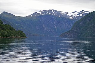
Tafjord is a village in Norddal Municipality in Møre og Romsdal county, Norway. The village is in a valley located at the end of the Tafjorden, about 12 kilometres (7.5 mi) southeast of the municipal centre of Sylte, and just west of the borders of Reinheimen National Park. In the park, the mountains Tordsnose, Karitinden, and Puttegga all lie about 15 kilometres (9.3 mi) to the southeast of Tafjord in the Tafjordfjella mountain range.

Luktvatnet is a lake that lies in the northern part of the municipality of Vefsn in Nordland county, Norway. The 3.76-square-kilometre (1.45 sq mi) lake lies between the mountains Korgfjellet and Lukttinden, about 5 kilometres (3.1 mi) south of the village of Elsfjord. The European route E06 highway passes along the northern shore of the lake.

Tysdalsvatnet or Tyssdalsvatnet is a lake in the municipalities of Hjelmeland and Strand in Rogaland county, Norway. The 3.74-square-kilometre (1.44 sq mi) lake lies about 5 kilometres (3.1 mi) south of the village of Årdal and about 8 kilometres (5.0 mi) east of the village of Tau. The Norwegian National Road 13 (Rv13) runs along the northern side of the lake. The Svo Tunnel was completed in 2013 and it routes much of Rv13 through a mountain rather than along the narrow shoreline of the lake.

Holmavatnet is a lake the Setesdalsheiene mountains of Southern Norway. It is located on the border of the municipalities of Suldal, Vinje, and a small part in Bykle. The southeastern corner of the lake is in Bykle, and it is the northernmost part of all of Aust-Agder county. The lake Skyvatn is located about 5 kilometres (3.1 mi) to the south of the lake.
Skyvatn is a lake in the northern part of the municipality of Bykle in Aust-Agder county, Norway. The lake is located south of the lake Holmavatnet and northwest of the lake Hartevatnet. The village of Hovden in Bykle is the nearest village, located about 9 kilometres (5.6 mi) southeast of the lake.

Eldrevatnet or Eldrevatn is a lake in the municipality of Lærdal in Sogn og Fjordane county, Norway. The 3.48-square-kilometre (1.34 sq mi) lake lies at an elevation of 1,116 metres (3,661 ft) above sea level. It is located about 15 kilometres (9.3 mi) southeast of the village of Borgund, not far from the European route E16 highway and the Filefjell Kongevegen road. The lake Øljusjøen lies 4 kilometres (2.5 mi) south of the lake. The lake Juklevatnet and the mountain Høgeloft both lie about 5 kilometres (3.1 mi) to the northeast of the lake.

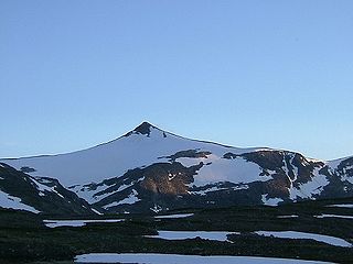
Puttegga or Pyttegga is the highest mountain in Møre og Romsdal county, Norway. It lies on the border of Norddal Municipality and Rauma Municipality. It is located just 4 kilometres (2.5 mi) northwest of the mountain Karitinden, inside Reinheimen National Park. The nearest village is Tafjord, 14 kilometres (8.7 mi) to the west. The mountain is easily accessed from the cabin Pyttbua to the east, which is maintained by the Norwegian Trekking Association.
Karitinden is a mountain in the Tafjordfjella mountain range inside Reinheimen National Park on the border of Møre og Romsdal and Oppland counties in Norway. The top of the mountain is a tripoint border junction for Skjåk Municipality, and Norddal Municipality and Rauma Municipality. The nearest village is Tafjord which lies 17 kilometres (11 mi) to the northwest. The lake Tordsvatnet lies 4 kilometres (2.5 mi) southeast of the mountain and the mountain Puttegga lies 4 kilometres (2.5 mi) to the northwest.

Tafjorden is an inner branch of the Norddalsfjorden/Storfjorden in Norddal Municipality in Møre og Romsdal county, Norway. The fjord is located southeast of the village of Sylte, the municipal center of Norddal Municipality. The small village of Tafjord is located at the end of the 12-kilometre (7.5 mi) long Tafjorden. The only road leading to the rather isolated village of Tafjord goes through the 5,277-metre (3.3 mi) long Heggur Tunnel plus several other smaller tunnels on the northern shore of the fjord.
Tordsnose is a mountain on the border of Norddal Municipality and Skjåk Municipality in Norway. The 1,975-metre (6,480 ft) tall mountain lies within the Tafjordfjella mountain range and within Reinheimen National Park, about 6 kilometres (3.7 mi) southwest of Karitinden and 8.5 kilometres (5.3 mi) south of Puttegga. The lake Grønvatnet sits 3 kilometres (1.9 mi) south of the mountain and the lake Tordsvatnet lies 8 kilometres (5.0 mi) straight east of the mountain.

Eidsdal is a village and valley in Norddal Municipality in Møre og Romsdal county, Norway. It is located along the south side of the Norddalsfjorden, about 7 kilometres (4.3 mi) southwest of the municipal centre of Sylte and the village of Norddal lies about 4 kilometres (2.5 mi) east of Eidsdal. The local church, Norddal Church is located in nearby Norddal village. Eidsdal has approximately 400 inhabitants.
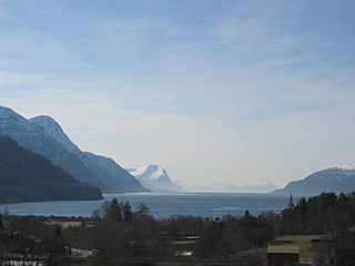
Storfjorden or Storfjord is a 110-kilometre (68 mi) long fjord in the Sunnmøre region of Møre og Romsdal county, Norway. It stretches from the village of Hareid in the west to the villages of Tafjord and Geiranger in the east. The Storfjorden system branches off into several smaller fjords including the famous Geirangerfjord and Tafjorden. At the village of Stranda, the main fjord branches off into the Sunnylvsfjorden-Geirangerfjorden to the west and the Norddalsfjorden-Tafjorden to the east.

Norwegian County Road 63 is a Norwegian county road in Møre og Romsdal county and a very small part in Oppland county, Norway. It begins at Norwegian National Road 15 along the lake Langvatnet in Skjåk Municipality in Oppland county and it heads north where it ends at the junction with the European route E136 highway near the town of Åndalsnes in Rauma Municipality, Møre og Romsdal county. The route runs for 103.6 kilometres (64.4 mi) including a single ferry crossing over the Norddalsfjorden. The vast majority of the road is in Møre og Romsdal county, only the southernmost 2.5 kilometres (1.6 mi) lie in the extreme western part of Oppland county. Both the Langvatnet–Geiranger and Trollstigen sections of the road are closed during winter and spring due to the weather conditions. The road passes by a number of notable landmarks, which has led to the earmarking of the route as national tourist route.

The Sunnylvsfjorden is a fjord in Stranda and Norddal in the Møre og Romsdal county of Norway. The 26-kilometre (16 mi) long Sunnylvsfjorden is one of the innermost branches of the large Storfjorden. The fjord ranges from 600 to 2,000 metres wide and reaches 452 metres (1,483 ft) below sea level at its deepest point, just west of Skrenakken near the mouth of the fjord. The famous Geirangerfjorden branches off to the west from the Sunnylvsfjorden.

Sylte or Valldal is the administrative center of Norddal Municipality in Møre og Romsdal county, Norway. The village is situated at the southern end of the Valldalen valley along the shore of the Norddalsfjorden near the mouth of the Valldøla river, just west of the entrance to the Tafjorden. The 0.71-square-kilometre (180-acre) village has a population (2012) of 411. This gives the village a population density of 579 inhabitants per square kilometre (1,500/sq mi).


