
The Medical University of Innsbruck is a university in Innsbruck, Austria. It used to be one of the four historical faculties of the Leopold-Franzens-Universität Innsbruck and became an independent university in 2004.

The Bergisel is a hill that lies to the south of Innsbruck, Austria, in the area of Wilten, where the Sill river meets the Inn Valley.

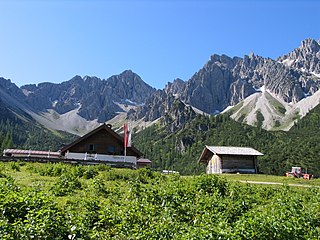
Seefeld in Tirol is an old farming village, now a major tourist resort, in Innsbruck-Land District in the Austrian state of Tyrol with a local population of 3,312. The village is located about 17 km (11 mi) northwest of Innsbruck on a plateau between the Wetterstein mountains and the Karwendel on a historic road from Mittenwald to Innsbruck that has been important since the Middle Ages. It was first mentioned in 1022 and since the 14th century has been a pilgrimage site, benefiting not only from the visit of numerous pilgrims but also from its stacking rights as a trading station between Augsburg and the Venice. Also since the 14th century, Tyrolean shale oil has been extracted in the area. Seefeld was a popular holiday resort even before 1900 and, since the 1930s, has been a well known winter sports centres and amongst the most popular tourist resorts in Austria. The municipality, which has been the venue for several Winter Olympics Games, is the home village of Anton Seelos, the inventor of the parallel turn.
Innsbruck, an Austrian city, was annexed by Nazi Germany in 1938. It was bombed 22 times by the Allies in World War II, suffering heavy damage.

The Hungerburgbahn is a hybrid funicular railway in Innsbruck, Austria, connecting the city district of Hungerburg with the city centre. The current line opened on 1 December 2007, replacing a previous alignment that operated from 1906 to 2005. The new Hungerburgbahn is one of the landmarks of the city, with stations designed by Zaha Hadid, and built by Leitner AG.

The Tyrolean Zugspitze Cable Car was the first wire ropeway to open the summit of the Zugspitze, Germany's highest mountain on the border of Austria. Designed and built by Adolf Bleichert & Co. of Leipzig, Germany, the system was a record-holder for the highest altitude.

The Hofgarten is a protected park located on the edge of the Altstadt section of Innsbruck, Austria. The park covers an area of 10 hectares, and borders on the Hofburg, the Kongresshaus, and the Tyrolean State Theatre.
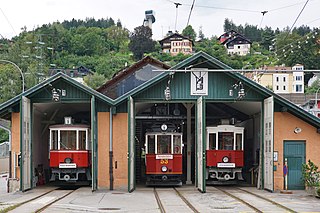
The Tyrolean Museum Railways or Tiroler MuseumsBahnen (TMB) is a railway society in Austria whose aim is the preservation and/or documentation of the historically important branch lines (known as Localbahnen) and their rolling stock in the state of Tyrol.

The Ausserfern Railway is a cross-border railway line in the German state of Bavaria and the Austrian state of Tyrol. The single-tracked branch line starts from Kempten in Germany, before crossing into Austria just after passing through Pfronten. It then transits the Außerfern area around Reutte, before passing back into Germany in order to terminate at Garmisch-Partenkirchen.

Außerfern refers to the district of Reutte in the Austrian federal state of Tyrol.

The Mittenwald Railway, popularly known as the Karwendelbahn, is a railway line in the Alps in Austria and Germany. It connects Innsbruck via Seefeld and Mittenwald to Garmisch-Partenkirchen.

Hinterriß is a Tyrolean village in Schwaz District, Austria, located at the Rißbach river at a height of 928 metres. Legally, Hinterriß is split up between the municipalities of Vomp and Eben am Achensee.

The Hafelekarspitze is a mountain in the so-called North Chain (Nordkette) north of Innsbruck in Austria.
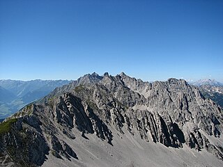
The Nordkette, also variously called the North Chain, Northern Range, rarely the Inn Valley Range or Inn Valley Chain (Inntalkette), is a range of mountains just north of the city of Innsbruck in Austria. It is the southernmost of the four great mountain chains in the Karwendel. To the west it is linked by the Erl Saddle to the Erlspitze Group, to the east via the Stempeljoch saddle to the Gleirsch-Halltal Range. To the south it is bounded by the Inn valley. Its highest summit is the Kleiner Solstein in the west of the range.

The Hohe Warte is a mountain, 2,597 m (AA) in height, in the Karwendel range in Austria. It is located between the Kleiner Solstein to the west and the Hintere Brandjochspitze to the east, in the Nordkette in the state of Tyrol, north of the Innsbruck quarter of Kranebitten and has a prominence of at least 77 metres.
The Erlspitze Group, also called the Seefeld Group, is the southwesternmost side range of the Austrian part of the Karwendel mountains in the Alps. It forms a horseshoe-shaped highland around the valley of Eppzirler Tal and is joined in the south to the Nordkette by the Erl Saddle (Erlsattel) near Solsteinhaus. It is bounded in the west by the Seefeld Basin, in the east by the valleys of the Gleirschtal and the Großes Kristental; its forested northern foothills reach as far as Scharnitz.

The Seefeld Plateau is a montane valley and basin landscape in the North Tyrolean Limestone Alps about 500 metres above the Inn valley in the Austrian state of Tyrol. The plateau covers the valley basin around the villages of Seefeld in Tirol and Scharnitz as well as the valley of Leutaschtal.

The Erlspitze, at 2,405 m (AA), is the highest mountain of the range to which it gives its name in the southeastern corner of the Karwendel Alps. Its pyramid-shaped summit makes it a good observation peak north of the Erl Saddle and the Solsteinhaus mountain hut.

The Solsteinhaus is an Alpine Club hut belonging to the Austrian Alpine Club located at a height of 1,806 m (AA) on the Erl Saddle (Erlsattel) between the mountains of the Nordkette and Erlspitze Group. It was opened in 1914 and totally renovated in 2007. It lies in the western Karwendel Alps in the state of Tyrol not far from the state capital of Innsbruck. Due to its central location and the numerous tour options it offers, the hut is a base for climbers taking part in tours of several days long, as well as a starting point for summit attempts. In addition the hut is a popular destination for hikers who can easily do a day tour to the hut. In winter the hut is closed, but there is a winter room for ski tourers. During safe avalanche conditions, high Alpine ski tours can be undertaken to the surrounding summits; but these all require good experience.

The Frau Hitt is a peak in the Nordkette, the southernmost mountain chain of the Karwendel in Austria. In appearance it resembles a woman on a horse, hence the name.

