Nordre Ekre (cadastral unit number 189, property unit number 1) is a farm in the lower part of the valley Heidal in Sel municipality, Norway. Some of the buildings on the farm date back from the 18th century. In 2004 the then owners were awarded the Norwegian Heritage sign of quality, Olavsrosa, for outreach activities and sustainable use of Norwegian heritage.[1] Nordre Ekre has been an agritourism farm since 1995, in the early years based mainly on self-catering.
Today the farmland is leased to neighbouring farmers, and the tourist offering has been expanded with a restaurant. The guest rooms have also been upgraded, but with the emphasis on retaining the original style, with exposed log walls and the original soapstone fireplaces. Nordre Ekre farm hotel and restaurant is one of five farms that form the partnership «Gardshotell i Gudbrandsdalen/Farm hotels in Gudbrandsdalen».
Nordre Ekre has been designated as «Travellers' choice» four years in a row (2013–2016) by the travel website TripAdvisor.[2]
The farm name
The first part of the name, «Nordre», is Norwegian for Northernmost or Northern. The oldest documented use of the main name, «Ekre», in the dative case and in the spelling of the period, is from 1333 when Sigurd, Hafthor Thoressön's vassal, wrote «Ek var a Eckru» (I was at Ekra).[3] The name suggests that the farm originally was an arable piece of land, that had been separated from another farm.[4]Oluf Rygh provided this etymology in Norske Gaardnavne (Norwegian Farm names) from 1897: «Ekra f., to field with grass, derived from Ager, derived from akr.» Rygh listed several documented forms of the name, e.g. «Ekren» in 1520, and «Ecre» in 1578.[5]
History
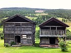
Søre Ekre glimpsed between Aurbua to the left and Eldhuset (the bakehouse) at Nordre EkreThe green room
Nordre Ekre has roots dating back to the Iron Age.[6] At that time there was only one Ekre-farm. In the 14th century this farm was a meeting place for things (assemblies) and court proceedings.[3]
The Ekre farm has been divided several times. The first documented division was in the early 1600s.[7] The farm later was divided into Nordre[8] and Søre (=southern) Ekre.[9] At the time they were located next to one another, where Søre Ekre is still located.
In 1851 Nordre Ekre was again divided into two farms, Nordre and Midtre (=middle) Ekre.[10] It was after this division that the current yard at Nordre Ekre was established. There are currently no buildings on the Midtre Ekre farm. The land under this farm was placed under Søre Ekre in 1926.
There were dairy cows at Nordre Ekre up until 1987, and hay and forestry until 1995, but since then tourism has formed the production basis for the farm. Both land and hunting rights are leased.
Nordre Ekre farm hotel and restaurant are owned by a married couple. The wife is the eighth generation of owners in her family.[7] The couple are both trained chefs, and since they took over the farm in 2005, they have upgraded the guest rooms and expanded the tourist offering with a gourmet restaurant in the former barn.[11][12]
The oldest buildings
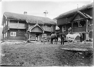
Site plan 2012Nordre Ekre from the south-west, ca. 2005The farm seen from the south-west, early 1900s
When the current yard was established, after the division in 1851, it was partly with buildings from the former location, partly with new buildings and partly with buildings that were moved from elsewhere. Photographs from the early 1900s show more buildings than those which currently stand on the farm.[13] Here were stables, a piggery and several other outbuildings, but the buildings were not so clearly defined in an inner and outer yard, as they are on som of the other Heidal farms. According to Norske gardsbruk[14] the farm is thought at one time to have comprised 17 buildings, including the mountain farm (summer pasture) and cabins.[15]
As farming changed over the years, more buildings were demolished and relocated. The stables were, for example, taken down and re-erected as a cottage, and the former barn was part of a larger cattle shed and barn, which has now been partly converted into guest rooms, as well as banqueting facilities and a farm museum.
The other six buildings from before the twentieth century today, form a not completely closed «firkanttun» (=square yard). The house lived in by the last generation farmers, is from 1976, and is pulled slightly back from the yard.
The buildings at Nordre Ekre are not listed or preserved, but the farm is part of the important cultural building environment and cultural landscape in Heidal, with and architectural finish, buildings and location in the terrain typical of the buildings in the valley from the 17th century onwards.[16] All the buildings around the yard are log houses from before 1900, and all, except for «Aurbua», are registered by the Norwegian Directorate for Cultural Heritage, in SEFRAK, a national register of old buildings and other national heritage sites and objects. The buildings are dated «1700s» in SEFRAK. The dating, and the fact that no buildings remain on the former site, now Midtre Ekre, makes it likely that most of the buildings were moved to Nordre Ekre with the farm division in 1851.
Søre stu
Søre is dialect for søndre=southern or southernmost. Stu is dialect for stue, which in this context means farmhouse. The name, or description, of the building therefore is The southern(-most) farmhouse. The building is said to have been moved here from Lom, but there is no contemporary documentation for this.[15] In the 1953 edition of Norske gardsbruk the actual move is dated to 1848, while the register in the 1998 edition cites 1860 as the year the building was moved to Nordre Ekre. The latter fits most closely with the facts, since the yard was established in 1851. The house was extended in width around 1942, and in length in 1995. The building is the residence of the current owners. Until the spring of 2013 it also housed the restaurant.
Nørdre stu
Nørdre stu=Northern farmhouse. This was the original farmhouse on the farm. After the erection of Søre stu, Nødre stu was used as a house for the retired farmer, until around 1960. At the time the building was moved here from its previous location, it only had one storey. The second storey was added in 1940, and the sod roof was also replaced with flat, hewn slate tiles. The building now contains four en suite guest rooms.
Aurbua
Aur=gravel, bua=the store room. This was the farm's cold storage. The building originally stood where today's kitchen in Søre stu is located. It was moved to the current location when Søre stu was expanded in 1995. The building is currently used as a farm shop. Aurbua is not mentioned specifically in the SEFRAK register.
Eldhuset
Eld=fire, huset=the house. This building is the farm's bakehouse, and has a wood fired traditional flat top baking oven and chimney, although its location, right among the other farm buildings, makes it unlikely that it was meant to be used as a bakehouse when it was moved to this location. Today the building is used for baking traditional flatbrød and lefse for – and on – special occasions, such as during the annual event «Gardmillom».
Stabburet
The storehouse. As with the other buildings, the date of the storehouse is uncertain. It is dated to the 1800s in the SEFRAK register and to the 1700s in vol. 2 of Gards- og slektshistorie for Heidal (=Farmstead and family history in Heidal). It was moved to the current location from the old yard.[7] Today it is furnished to provide guest accommodation on both the ground and first floors.
Kårfolkets stabbur
The retired generation's storehouse. This building was also moved from the original Ekre yard. It has now been converted into a library lounge on the ground floor, and houses an en suite guest room on the first floor. This building is believed to be the oldest building on the farm. It may have been built as early as the 17th century.[17]
Steinfjøset
Stein=stone, fjøset=the cowshed. This is the oldest part of the barn, dated to the 18th century in SEFRAK, while vol. 2 of Gards- og slektshistorie for Heidal cites 1870 as the year of construction. The barn was rebuilt in 1961 and expanded in 1980. In 2012/2013 it was completely renovated and converted into the farm's restaurant as it is today, as well as providing an additional guest room. The restaurant in the barn was opened in 2013, after having been located in Søre stu for some years.
The oldest buildings in the yard at Nordre Ekre
«Søre stu»
The two «stabbur». Kårfolkets stabbur to the right
«Eldhuset»
«Aurbua»
«Nørdre stu»
Like most farms in Heidal, Nordre Ekre also has a mountain farm or shieling. It is located on the west side of the Sjoa river, at the foot of the mountain Heidalsmuen. The buildings here were set up in the late 19th century. Today the place is no longer in use as a summer pasture, but is rented out for shorter or longer periods.
Related Research Articles
Oppland is a former county in Norway which existed from 1781 until its dissolution on 1 January 2020. The old Oppland county bordered the counties of Trøndelag, Møre og Romsdal, Sogn og Fjordane, Buskerud, Akershus, Oslo and Hedmark. The county administration was located in the town of Lillehammer.
Lesja is a municipality in Innlandet county, Norway. It is located in the traditional district of Gudbrandsdal. The administrative centre of the municipality is the village of Lesja. Other villages in the municipality include Bjorli, Lesjaskog, Lesjaverk, and Lora.
Vågå is a municipality in Innlandet county, Norway. It is located in the traditional district of Gudbrandsdal. The administrative centre of the municipality is the village of Vågåmo. Other village areas in Vågå include Lalm and Bessheim.
Sel is a municipality in Innlandet county, Norway. It is located in the traditional district of Gudbrandsdal. The administrative centre of the municipality is the town of Otta. The municipality also includes several notable villages including Bjølstad, Dale, Høvringen, Nord-Sel, Sandbumoen, Sjoa, and Skogbygda.
Lødingen is a municipality in Nordland county in Norway. Lødingen is located on the southeastern corner of the island of Hinnøya, and is part of the traditional district of Ofoten. The administrative centre of the municipality is the village of Lødingen. The other main part of the municipality is Vestbygda. Lødingen has the nickname "Biketown" because it hosts several annual bicycle races, including "Lofoten Insomnia" and Vestbygd-rittet.
Gudbrandsdalen is a valley and traditional district in the Norwegian county of Innlandet. The valley is oriented in a north-westerly direction from Lillehammer and the lake of Mjøsa, extending 230 kilometers (140 mi) toward the Romsdalen valley. The river Gudbrandsdalslågen (Lågen) flows through the valley, starting from the lake Lesjaskogsvatnet and ending at the lake Mjøsa. The Otta river which flows through Otta valley is a major tributary to the main river Lågen. The valleys of the tributary rivers such as Otta and Gausa (Gausdal) are usually regarded as part of Gudbrandsdalen. The total area of the valley is calculated from the areas of the related municipalities. Gudbrandsdalen is the main valley in a web of smaller valleys. On the western side there are long adjacent valleys: Ottadalen stretches 100 kilometers (62 mi) from Otta village, Gausdal some 50 kilometers (31 mi) from Lillehammer and Heidal some 40 kilometers (25 mi) from Sjoa. Gudbrandsdalen runs between the major mountain ranges of Norway including Jotunheimen and Dovrefjell–Rondane.
Ivar Kleiven was a Norwegian politician, historian and poet. He is most remembered as a collector of local folklore.
Heidal or Heidalen is a valley in Sel Municipality in Innlandet county, Norway. The U-shaped valley follows the river Sjoa which begins in the nearby Jotunheimen mountains eastward until it joins the Gudbrandsdalslågen river in the main valley which runs through the region, Gudbrandsdalen. The western end of the Sjoa river valley is in Vågå Municipality and there, it is called the Sjodalen valley. From 1908-1965, the Heidal valley was an independent municipality called Heidal, and since 1965, it has been a part of Sel Municipality. The main urban area in the valley is the village of Bjølstad.
Bagn Bydesamling is a small museum located in the hamlet of Dolven, south of Bagn at Sør-Aurdal in Innlandet county Norway. The museum is situated in the traditional district of Valdres and is run as a subsidiary of Valdres Folkemuseum.
Lavik og Brekke is a former municipality in the old Sogn og Fjordane county in Norway. It is in the present-day municipalities of Gulen and Høyanger in Vestland county. It was part of the traditional district of Sogn. The 427-square-kilometre (165 sq mi) municipality was located along the Sognefjorden, at the western end of the fjord, just east of the mouth. The municipality existed from 1861 until 1905. The administrative center of Lavik og Brekke was the village of Lavik. There were two churches in the municipality: Lavik Church in Lavik on the north side of the fjord and Brekke Church in Brekke on the south side of the fjord.
Mosvik og Verran is a former municipality in the old Nord-Trøndelag county in Norway. The 552-square-kilometre (213 sq mi) municipality existed from 1867 until 1901 when it was split into two. It was located on the Fosen peninsula, on the west side of the Trondheimsfjord. It included the southern part of what is now the municipality of Inderøy and the southern part of the present municipality of Steinkjer. The municipality was centered around the Verrasundet strait, a branch of the Trondheimsfjord. The administrative centre was the village of Mosvik where the Mosvik Church was located.
Paul Thorsen Harildstad was a Norwegian farmer who served as a representative at the Norwegian Constitutional Assembly at Eidsvoll in 1814.
Håkås, formerly spelled Haagaas and Haakaas, is a hill and an area near the lake Øyeren in Båstad in Trøgstad, Østfold, Norway, 25 kilometres southeast of Oslo. It is also the name of three neighbouring farms in the immediate vicinity of the hill. In 2016 the Håkås nature reserve was established by the King-in-Council; consisting of the Håkås forests near Øyeren, it was fully protected due to its importance to biodiversity.
Heidal Church is a parish church of the Church of Norway in Sel Municipality in Innlandet county, Norway. It is located in the village of Bjølstad, in Heidal, a side valley of the main Gudbrandsdalen valley. It is the church for the Heidal parish which is part of the Nord-Gudbrandsdal prosti (deanery) in the Diocese of Hamar. The brown, wooden church was built in a cruciform design in 1941 using plans drawn up by the architect Bredo Berntsen. The church seats about 292 people.
The Bjølstad Farm is a farm in Heidal in the municipality of Sel in Innlandet county, Norway.
Sandstad is a former municipality in the old Sør-Trøndelag county, Norway. The 160-square-kilometre (62 sq mi) municipality existed from 1914 until its dissolution in 1964 when it was merged into what is now Hitra municipality in Trøndelag county. The former municipality of Sandstad included all of the southern and southeastern parts of the island of Hitra, plus the several islands in the Trondheimsleia off the shores of Hitra. The municipality had one church, Sandstad church, located in the village of Sandstad.
Harran is a former municipality in the old Nord-Trøndelag county, Norway. The municipality existed from 1923 until its dissolution in 1964. The municipality was located in the Namdalen valley and it included all of what is now the northern part of the municipality of Grong in Trøndelag county. The administrative centre was the village of Harran where the Harran Church is located.
Nord-Gudbrandsdal Deanery is a deanery within the Diocese of Hamar in the Church of Norway. This deanery covers several municipalities in the northwestern part of the diocese. It includes churches in the municipalities of Dovre, Lesja, Lom, Nord-Fron, Sel, Skjåk, and Vågå. The deanery is headquartered at Sel Church in the north side of the town of Otta in Sel Municipality.
Heidal is a former municipality in the old Oppland county, Norway. The 349-square-kilometre (135 sq mi) municipality existed from 1908 until its dissolution in 1965. The former municipality is now part of the present-day Sel Municipality in Innlandet county. The administrative centre of the old municipality was the village of Bjølstad where the Heidal Church is located. The municipality encompassed the whole Heidal valley area.
This page is based on this Wikipedia article Text is available under the CC BY-SA 4.0 license; additional terms may apply. Images, videos and audio are available under their respective licenses.