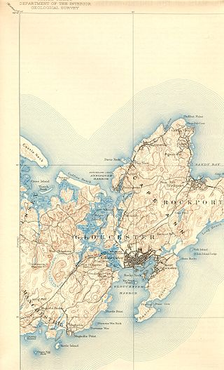
Gloucester is a city in Essex County, Massachusetts, in the United States. It sits on Cape Ann and is a part of Massachusetts's North Shore. The population was 29,729 at the 2020 U.S. Census. An important center of the fishing industry and a popular summer destination, Gloucester consists of an urban core on the north side of the harbor and the outlying neighborhoods of Annisquam, Bay View, Lanesville, Folly Cove, Magnolia, Riverdale, East Gloucester, and West Gloucester.

Shelby Charter Township, officially the Charter Township of Shelby, is a charter township located in Macomb County in the U.S. state of Michigan. The township is an affluent northern suburb of Detroit. As of the 2020 census, the population was 79,408, up from 73,804 in 2010. Shelby Charter Township is one of the fastest-growing communities in Metro Detroit.

Cape Ann is a rocky peninsula in northeastern Massachusetts on the Atlantic Ocean. It is about 30 miles (48 km) northeast of Boston and marks the northern limit of Massachusetts Bay. Cape Ann includes the city of Gloucester and the towns of Essex, Manchester-by-the-Sea and Rockport.
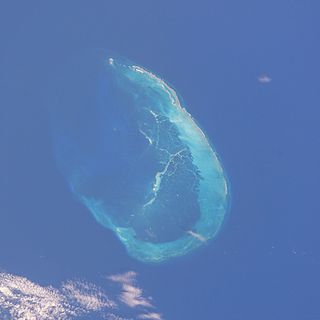
The French Frigate Shoals is the largest atoll in the Northwestern Hawaiian Islands. Its name commemorates French explorer Jean-François de La Pérouse, who nearly lost two frigates when attempting to navigate the shoals. It consists of a 20-mile-long (32 km) crescent-shaped reef, twelve sandbars, and the 120-foot-high (37 m) La Pèrouse Pinnacle, the only remnant of its volcanic origins. The total land area of the islets is 61.508 acres (24.891 ha), while the total coral reef area of the shoals is over 232,000 acres (94,000 ha). Tern Island, with an area of 26.014 acres (10.527 ha), has a landing strip and permanent habitations for a small number of people. It is maintained as a field station in the Hawaiian Islands National Wildlife Refuge by the United States Fish and Wildlife Service. The French Frigate Shoals are about 487 nautical miles northwest of Honolulu. Among the shoals are Tern, which is unique in having an airstrip and is protected by a seawall, and La Perouse Pinnacle, a tall and rocky island in the center of the shoals. The two largest islands after Tern, East and Trig have mostly washed away, with East being about half the size from storms, but are famed as breeding grounds for turtles. East was also home to Coast Guard base in the late 20th century. The islands are surrounded by a coral reef, and the islands themselves are noted breeding ground for turtles, seals, and birds. Habitation is difficult with little vegetation and no fresh water. In the 20th century the French Frigate Shoals are also called Lalo as part of the marine nature reserve, and along with other islands are visited periodically for research. The highest point in the shoals is on La Perouse Pinnacle which is a volcanic rock that rises 122 ft (37 m) above the surrounding lagoon.

"The Wreck of the Hesperus" is a narrative poem by American poet Henry Wadsworth Longfellow, first published in Ballads and Other Poems in 1842. It is a story that presents the tragic consequences of a skipper's pride. On an ill-fated voyage in winter, he brings his daughter aboard ship for company. The skipper ignores the advice of one of his experienced men, who fears that a hurricane is approaching. When the storm arrives, the skipper ties his daughter to the mast to prevent her from being swept overboard. She calls out to her dying father as she hears the surf beating on the shore, then prays to Christ to calm the seas. The ship crashes onto the reef of Norman's Woe and sinks; the next morning a horrified fisherman finds the daughter's body, still tied to the mast and drifting in the surf. The poem ends with a prayer that all be spared such a fate "on the reef of Norman's Woe."
Annisquam is a waterfront village in the city of Gloucester, on the North Shore of Massachusetts. It is a few miles across Cape Ann from downtown Gloucester.

HMCS Yukon was a Mackenzie-class destroyer that served in the Royal Canadian Navy (RCN) and later the Canadian Forces. She was the first Canadian naval unit to carry the name. She was named for the Yukon River that runs from British Columbia through Yukon and into Alaska in the United States.

The Manacles are a set of treacherous rocks off The Lizard peninsula in Cornwall. The rocks are rich in marine wildlife and they are a popular spot for diving due to the many shipwrecks. Traditionally pronounced mean-a'klz (1808), the name derives from the Cornish meyn eglos, the top of St Keverne church spire being visible from the area.
The Annisquam River is a tidal, salt-water estuary in the Annisquam neighborhood of Gloucester, Massachusetts, connecting Annisquam Harbor on the north to Gloucester Harbor on the south. The segment between Gloucester Harbor and the Newburyport/Rockport Line bridge is also known as the Blynman Canal.
MV Adolphus Busch was a cargo ship that was sunk off of Looe Key, Florida, as an artificial reef and dive site.

The SS Mohegan was a steamer which sank off the coast of the Lizard Peninsula, Cornwall, on her second voyage. She hit The Manacles on 14 October 1898 with the loss of 106 out of 197 on board.
Wreck Alley is an area a few miles off the coast of Mission Beach, San Diego, California with several ships intentionally sunk as artificial reefs and as Scuba diving attractions for wreck divers.

SS Benwood was a steam cargo ship of the early twentieth century. Built by Craig, Taylor & Co Ltd., Stockton on Tees, she entered service with Joseph Hoult & Co. Ltd, Liverpool. She passed through several owners, before being lost in a collision off the coast of Key Largo, Florida in 1942. Her wreck is now a popular dive site.

Thacher Island is a small island off Cape Ann on the Massachusetts coast in the United States. It is a part of the Town of Rockport. It was a place where some naval confrontations, both minor and major, took place, which helped secure a victory for the colonists.
Octopus Hole Conservation Area is defined as those waters, tidelands, and bedlands of Hood Canal within a line projected due east from the western shore of Hood Canal on latitude 47°27'01"N for 200 yards, thence southerly 628 yards parallel to the high watermark to latitude 47°26'40", thence due west to shore.
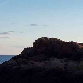
Mother Ann is a rock formation located near the Eastern Point Lighthouse in Gloucester, Massachusetts, United States. When viewed at the correct angle, the formation appears to be the silhouette of a reclining Puritan woman. It is also believed locally that the formation represents the royal mother of King Charles I, Anne of Denmark, after whom Cape Ann is named.

Good Morning Gloucester is a longstanding blog created by Gloucester, Massachusetts lobster broker Joey Ciaramitaro. GMG is a snapshot of living and working on the docks of the oldest commercial fishing harbor in the United States.

Stage Fort Park is a park at Stage Head in Gloucester, Massachusetts, part of the Essex National Heritage Area. It contains two beaches, a large playground, picnic benches, two baseball fields, a basketball court, a dog park and plenty of room for any weekend activities. The park includes Gloucester's Visitor and Welcome Center and Stage Fort, a reconstructed Civil War fort on a site fortified since 1635.
Shark River Reef is an artificial reef located in the Atlantic Ocean, 15.6 miles southeast of Manasquan Inlet, off of the coast of Ocean County, New Jersey. The site contains almost 4 million cubic yards of dredge rock material. Although 96% of the total reef material is rock, the site also contains numerous subway cars.
