Related Research Articles

The location at the junction of the Mediterranean, the Alps, the Dinarides and the Pannonian Plain and the area being traversed by major rivers have been the reasons for the intersection of the main transport routes in Slovenia. Their course was established already in Antiquity. A particular geographic advantage in recent times has been the location of the intersection of the Pan-European transport corridors V and X in the country. This gives it a special position in the European social, economic and cultural integration and restructuring.
The Free Territory of Trieste was an independent territory situated in Central Europe between northern Italy and Yugoslavia, facing the north part of the Adriatic Sea, under direct responsibility of the United Nations Security Council in the aftermath of World War II. It acted essentially as a free city.

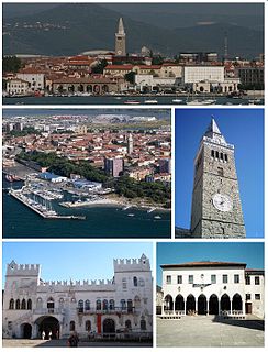
Rijeka is the principal seaport and the third-largest city in Croatia. It is located in Primorje-Gorski Kotar County on Kvarner Bay, an inlet of the Adriatic Sea and in 2011 had a population of 128,624 inhabitants. Historically, because of its strategic position and its excellent deep-water port, the city was fiercely contested, especially among Italy, Hungary, and Croatia, changing hands and demographics many times over centuries. According to the 2011 census data, the majority of its citizens are Croats, along with a large minority of Serbs, and smaller numbers of Bosniaks and Italians.
Koper is the fifth largest city in Slovenia. Located in the Istrian region in southwestern part of the country, approximately five kilometres south of the border with Italy and 20 kilometres from Trieste, Koper is the largest coastal city in the country. It is bordered by the satellite towns of Izola and Ankaran. With a unique ecology and biodiversity, it is considered an important natural resource. The city's Port of Koper is the major contributor to the economy of the Municipality of Koper. With only one percent of Slovenia having a coastline, the influence that the Port of Koper also has on tourism was a factor in Ankaran deciding to leave the municipality in a referendum in 2011 to establish its own. The city is a destination for a number of Mediterranean cruising lines. Koper is the main urban centre of the Slovenian Istria, with a population of about 25,000. Ales Brzan is the current mayor, serving since 2018.

Piran is a town in southwestern Slovenia on the Gulf of Piran on the Adriatic Sea. It is one of the three major towns of Slovenian Istria. The town is known for its medieval architecture, with narrow streets and compact houses. Piran is the administrative seat of the Municipality of Piran and one of Slovenia's major tourist attractions. Until the mid-20th century, Italian was the dominant language, but it was replaced by Slovene as demographics shifted.

Krk is a Croatian island in the northern Adriatic Sea, located near Rijeka in the Bay of Kvarner and part of Primorje-Gorski Kotar county. Krk is the largest Adriatic island, with an area of 405.80 km2 (156.68 sq mi), Krk is the most populous island in the Adriatic Sea, with multiple towns and villages that contain a total of 19,383 (2011) inhabitants.

Venezia Giulia, traditionally called Julian March or Julian Venetia is an area of southeastern Europe which is currently divided among Croatia, Italy and Slovenia. The term was coined in 1863 by the Italian linguist Graziadio Isaia Ascoli, a native of the area, to demonstrate that the Austrian Littoral, Veneto, Friuli and Trentino shared a common Italian linguistic identity. Ascoli emphasized the Augustan partition of Roman Italy at the beginning of the Empire, when Venetia et Histria was Regio X.

The Austrian Littoral was a crown land (Kronland) of the Austrian Empire, established in 1849. It consisted of three regions: the Istria peninsula, Gorizia and Gradisca, and the Imperial Free City of Trieste. Throughout history, the region has been frequently contested, with parts of it controlled at various times by the Republic of Venice, Austria-Hungary, Italy, and Yugoslavia among others.

Croatian Littoral is a historical name for the region of Croatia comprising mostly the coastal areas between traditional Dalmatia to the south, Mountainous Croatia to the north, Istria and the Kvarner Gulf of the Adriatic Sea to the west. The term "Croatian Littoral" developed in the 18th and 19th centuries, reflecting the complex development of Croatia in historical and geographical terms.

The A7 motorway is a 42.4-kilometre-long (26.3 mi) motorway in Croatia. It connects the nation's largest port in Rijeka, to the Croatian motorway network, as well as to the Rupa and Pasjak border crossings to Slovenia. The motorway forms part of a longitudinal transportation corridor in Croatia, and it is a part of European route E61 Villach–Ljubljana–Trieste–Rijeka. The A7 motorway route south of Orehovica interchange, where it also intersects Pan-European corridor Vb, is a part of European route E65.

The European route E751, or E751, as defined by the Declaration on the Construction of Main International Traffic Arteries of 1975, and subsequent documents which amended the treaty, is an east-west Class-B branching European road route. Originating in Rijeka, Croatia, where it diverges from European route E61 before passing through the Kanfanar interchange, the route connects Pula, Rovinj, Poreč and Umag in Croatia with Koper in Slovenia. The route provides a high-performance road link in Istria and Slovenian Littoral. Unlike most routes, the E751 centers on the Kanfanar interchange and has three arms, each extending to Rijeka, Pula and Koper. The total length of the route, including all the route arms, is 160 km (99 mi).
The Bay of Bakar is located on the Croatian Adriatic coast, within the Gulf of Kvarner. There are two towns centered on bay of Bakar: Bakar and Kraljevica. While Bakar and Kraljevica are port towns, in outback of bay of Bakar there are the industry zones and free zones of Kukuljanovo. The bay itself contains Bulk Cargo Terminal of the Port of Rijeka, handling coal, iron ore and bulk cargo. Its annual capacity is 4 million tonnes and it accommodates Capesize ships. The port facilities are planned to be expanded through construction of a car terminal in the bay.
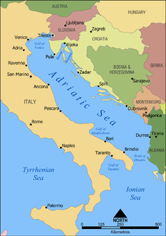
The Adriatic Sea is a body of water separating the Italian Peninsula from the Balkans. The Adriatic is the northernmost arm of the Mediterranean Sea, extending from the Strait of Otranto to the northwest and the Po Valley. The countries with coasts on the Adriatic are Albania, Bosnia and Herzegovina, Croatia, Italy, Montenegro and Slovenia. The Adriatic contains over 1,300 islands, mostly located along the Croatian part of its eastern coast. It is divided into three basins, the northern being the shallowest and the southern being the deepest, with a maximum depth of 1,233 metres (4,045 ft). The Otranto Sill, an underwater ridge, is located at the border between the Adriatic and Ionian Seas. The prevailing currents flow counterclockwise from the Strait of Otranto, along the eastern coast and back to the strait along the western (Italian) coast. Tidal movements in the Adriatic are slight, although larger amplitudes are known to occur occasionally. The Adriatic's salinity is lower than the Mediterranean's because the Adriatic collects a third of the fresh water flowing into the Mediterranean, acting as a dilution basin. The surface water temperatures generally range from 30 °C (86 °F) in summer to 12 °C (54 °F) in winter, significantly moderating the Adriatic Basin's climate.

Port of Koper is a public limited company, which provides port and logistics services in the only Slovenian port, in Koper. It is situated in the northern part of the Adriatic Sea, connecting mainly markets of Central and Southeast Europe with the Mediterranean Sea and Far East. Differently from other European ports, which are managed by port authorities, the activities of Port of Koper comprise the management of the free zone area, the management of the port area and the role of terminal operator.

The highways in Slovenia are the central state roads in Slovenia and are divided into motorways and expressways. Motorways are dual carriageways with a speed limit of 130 kilometres per hour (81 mph). They have white-on-green road signs as in Italy, Croatia and other countries nearby. Expressways are secondary roads, also dual carriageways, but without an emergency lane. They have a speed limit of 110 kilometres per hour (68 mph) and have white-on-blue road signs.

The Port of Split is a port in the central Dalmatian city of Split, Croatia. The port was originally a trading post originally established by Greek settlers from the island of Vis and subsequently taken over by the Romans. The port thrived through the Middle Ages, but it suffered a decline in the late 18th and early 19th centuries when the Port of Rijeka took over as the primary trading and shipping outlet of the region. The decline was also attributed to the decline of the Ottoman Empire, a traditional market for the Port of Split, and the growing domination of Austrian Empire.
The Port of Ploče is a seaport in Ploče, Croatia, near the mouth of the Neretva river on the Adriatic Sea coast. It was formally opened in 1945 after a railway was built as a supply route to connect the site with industrial facilities in the Sarajevo and Mostar areas of Bosnia and Herzegovina, which was then part of Yugoslavia. As of 2010, it ranked as the second largest cargo port in Croatia—after the Port of Rijeka—with a cargo throughput of 4.5 million tonnes, consisting mostly of general cargo and bulk cargo, including 20,420 twenty-foot equivalent units (TEUs). In 2008, the Port of Ploče recorded 2,555 ship arrivals. It is managed by the Port of Ploče Authority.
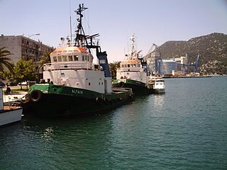
The Port of Rijeka is a seaport in Rijeka, Croatia, located on the shore of the Kvarner Gulf in the Adriatic Sea. The first records of the port date to 1281. It was the main port of the Kingdom of Hungary in the 19th century and the beginning of the 20th century, of Yugoslavia between World War II and 1991, and of Croatia after its independence. Today, it is the largest port in Croatia with a cargo throughput of 11.2 million tonnes (2016), mostly oil, general cargo and bulk cargo, and 214,348 Twenty-foot equivalent units (TEUs).

The Slovene Riviera is the coastline of Slovenia, located on the Gulf of Trieste, by the Adriatic Sea. It is part of the Istrian peninsula and is 46.6 km long. The region comprises the towns of Koper and Piran with Portorož, and the municipality of Izola. It is a seaside tourist destination, with a vibrant multiethnic Slovenian and Italian heritage.

The Mediterranean Corridor is the number 3 of the ten priority axes of the Trans-European Transport Network (TEN-T).
References
- ↑ "About NAPA". North Adriatic Ports Association. Retrieved August 27, 2011.
- ↑ "Signed the founding of the NAPA in Trieste, Rijeka is expected to join in". Ministry of the Sea, Transport and Infrastructure (Croatia). March 2, 2010. Retrieved August 27, 2011.
- ↑ "Port of Rijeka – Fifth Star of NAPA". North Adriatic Ports Association. November 29, 2010. Retrieved August 27, 2011.
- ↑ Darko Pajić (July 2, 2011). "Za udruživanje riječke luke, Kopra, Trsta i Venecije EU daje 1,45 milijuna eura" [EU grants 1.45 million euro for association of ports of Rijeka, Kopar, Trieste and Venice]. Novi list (in Croatian). Retrieved August 27, 2011.
http://www.portsofnapa.com/index.php?t=news&l=en&id=111
| This article related to ports, harbors or marinas is a stub. You can help Wikipedia by expanding it. |