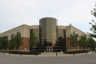
Canton Township is a charter township in Wayne County in the U.S. state of Michigan. A western suburb of Detroit, Canton is located roughly 23 miles (37.0 km) west of downtown Detroit, and 15 miles (24.1 km) east of Ann Arbor. As of the 2020 census, the township had a population of 98,659, making it Michigan's second most-populated township and ninth most-populated municipality overall.

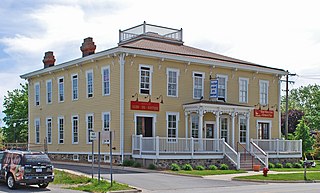
Nyack is a village located primarily in the town of Orangetown in Rockland County, New York, United States. Incorporated in 1872, it retains a very small western section in Clarkstown. The village had a population of 7,265 as of the 2020 census. It is a suburb of New York City lying approximately 15 miles (24 km) north of the Manhattan boundary near the west bank of the Hudson River, situated north of South Nyack, east of Central Nyack, south of Upper Nyack, and southeast of Valley Cottage.

Prescott is a town on the north shore of the Saint Lawrence River in province of Ontario, Canada. The town is a part of the United Counties of Leeds and Grenville. In 2021, it had a population of 4,078. The Ogdensburg–Prescott International Bridge, 5 kilometres (3.1 mi) east of Prescott at Johnstown, crosses the Canada–United States border and connects the town with the city of Ogdensburg, New York.

Rossville is a neighborhood of Staten Island, New York, on the island's South Shore. It is located to the north of Woodrow, to the west of Arden Heights, and to the south and east of the Arthur Kill. Rossville is located within Staten Island Community Board 3.

Edmonton is a town in north London, England within the London Borough of Enfield, a local government district of Greater London. The northern part of the town is known as Lower Edmonton or Edmonton Green, and the southern part as Upper Edmonton. Situated 8.4 miles (13.5 km) north-northeast of Charing Cross, it borders Enfield to the north, Chingford to the east, and Tottenham to the south, with Palmers Green and Winchmore Hill to the west. The population of Edmonton was 82,472 as of 2011.

Ardmillan is a mainly residential suburb of Edinburgh, Scotland. The area developed during the mid to late Victorian era as Edinburgh expanded and many of the present tenement flats and houses date from this era. The area is bisected by the A70 road and its north-west edge is marked by the Shotts railway line. The area has several pubs, small shops, churches and a cemetery.

Westgate is a community within the Hilltop area of Columbus, Ohio. It was partially constructed on land that formerly housed the American Civil War Camp Chase and a Confederate prison. After the Civil War, the land was purchased by Joseph Binns and his associates with the intent to start a Quaker community. These plans failed to materialize and the land was developed as a "streetcar suburb" in the 1920s. Located 4 miles (6.4 km) west of downtown, the neighborhood is home to Westgate Park and Recreation Center, Westgate Alternative Elementary School, St. Mary Magdalene Church and school, and Parkview United Methodist Church. 4,500 residents live within the Westgate boundaries, most in single family houses.

Spencerville is a rural community located in Eastern Ontario, within Edwardsburgh/Cardinal township in the United Counties of Leeds and Grenville. The village lies about 80 kilometers southwest of downtown Ottawa on Highway 416. The South Nation River runs through the village.

DeWitty, later renamed Audacious, was a village in Cherry County, Nebraska, United States. The settlement, which was founded in 1907 and disincorporated in 1936, was located 10 miles (20 km) north and west of Brownlee. DeWitty was Nebraska's "largest and most permanent colony" of African American homesteaders.

Mount Olivet United Methodist Church is a United Methodist Church located in Arlington County, Virginia. The church occupies the oldest church site in continuous use in Arlington County. The church and its cemetery are located at the southwest corner of Glebe Road and 16th Street North.
Cherry Hill is an unincorporated community in Wayne County in the U.S. state of Michigan. The community is located within Canton Township along Cherry Hill and Ridge Roads but otherwise has no legally defined boundaries or population statistics. The Cherry Hill Historic District is a primarily residential historic district encompassing the greater part of Cherry Hill. It was listed on the National Register of Historic Places in 2003.
The Allegheny Wesleyan Methodist Connection (AWMC), also styled as the Wesleyan Methodist Church (Original Allegheny Conference), is a Methodist denomination within the conservative holiness movement. It is primarily based in the United States, with missions in Peru, Ghana, and Haiti. The Allegheny Wesleyan Methodist Connection is currently led by Rev. David Blowers (President) and Rev. Joseph Smith (Vice President).
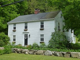
The Canton Center Historic District encompasses the historic rural town center of Canton, Connecticut, United States. Extending mainly along Connecticut Route 179, near the geographic town center, is a well-preserved example of a rural agricultural center in Connecticut, a role served until about 1920. The district includes many examples of Late Victorian and Greek Revival architecture. It was listed on the National Register of Historic Places in 1997.

Mount Zion Cemetery/Female Union Band Society Cemetery is a historic cemetery located at 27th Street NW and Mill Road NW in the Georgetown neighborhood of Washington, D.C., in the United States. The cemetery is actually two adjoining burial grounds: the Mount Zion Cemetery and Female Union Band Society Cemetery. Together these cemeteries occupy approximately three and a half acres of land. The property fronts Mill Road NW and overlooks Rock Creek Park to the rear. Mount Zion Cemetery, positioned to the East, is approximately 67,300 square feet in area; the Female Union Band Cemetery, situated to the West, contains approximately 66,500 square feet. Mount Zion Cemetery, founded in 1808 as The Old Methodist Burial Ground, was leased property later sold to Mount Zion United Methodist Church. Although the cemetery buried both White and Black persons since its inception, it served an almost exclusively African American population after 1849. In 1842, the Female Union Band Society purchased the western lot to establish a secular burying ground for African Americans. Both cemeteries were abandoned by 1950.

Open Road Park is a small park in East Village, Manhattan, New York City, located east of First Avenue between 11th and 12th Streets. It is among the larger green spaces created in the East Village as a result of community organizing. The site of this park was taken over in 1993 by Open Road, a neighborhood nonprofit that developed the lot into a community garden and playground. Prior to its use as a park, the site was used for many purposes that reflect on the history of the surrounding neighborhood.
Robtown is an unincorporated community in Pickaway County, in the U.S. state of Ohio. The area is located approximately five miles west of South Bloomfield, Ohio and three miles northeast of Darbyville, Ohio, on the banks of Grave Run, a tributary of the Scioto River, and at the crossroads of Ohio State Route 316 and Turney Caldwell Road.
Grassyville is a ghost town located in Bastrop County, Texas, United States. The community was founded in the northeastern corner of the county, near the intersection of Farm to Market Road 2104 and Farm to Market Road 2239, six miles south of Paige, 14 miles east of Bastrop, and 50 miles east of Austin.
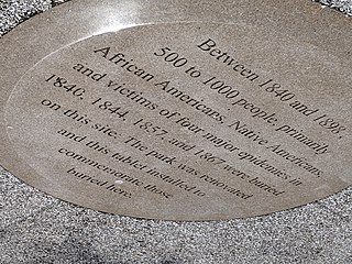
Old Town of Flushing Burial Ground is a historic cemetery located in Flushing, Queens, New York City. It was established in 1840 and known as The Olde Towne of Flushing Burial Ground. It was the result of Cholera and Smallpox epidemics in 1840 and 1844, added by town elders north of Flushing Cemetery due to fears of contamination of church burial grounds. Once known as "Pauper Burial Ground", "Colored Cemetery of Flushing" and "Martins Field", it was purchased by the New York City Department of Parks and Recreation on December 2, 1914, and renamed in 2009 to "The Olde Towne of Flushing Burial Ground".

