
The Blue Ridge Parkway is a National Parkway and All-American Road in the United States, noted for its scenic beauty. The parkway, which is America's longest linear park, runs for 469 miles (755 km) through 29 Virginia and North Carolina counties, linking Shenandoah National Park to Great Smoky Mountains National Park. It runs mostly along the spine of the Blue Ridge, a major mountain chain that is part of the Appalachian Mountains. Its southern terminus is at U.S. Route 441 (US 441) on the boundary between Great Smoky Mountains National Park and the Qualla Boundary of the Eastern Band of Cherokee Indians in North Carolina, from which it travels north to Shenandoah National Park in Virginia. The roadway continues through Shenandoah as Skyline Drive, a similar scenic road which is managed by a different National Park Service unit. Both Skyline Drive and the Virginia portion of the Blue Ridge Parkway are part of Virginia State Route 48 (SR 48), though this designation is not signed.
U.S. Route 276 is a United States highway that runs for 106.4 miles (171.2 km) from Mauldin, South Carolina to Cove Creek, North Carolina. It is known both as a busy urban highway in Greenville, South Carolina and a scenic back-road in Western North Carolina.
U.S. Route 19E (US 19E) is a divided highway of US 19 in the U.S. states of North Carolina and Tennessee. The U.S. Highway, which is complemented by US 19W to the west, travels 75.9 miles (122.1 km) from US 19 and US 19W at Cane River, North Carolina, north to US 11E, US 19, and US 19W in Bluff City, Tennessee. US 19E connects Asheville, North Carolina, and Bristol, Tennessee, with Burnsville, Spruce Pine, and Elk Park in North Carolina and Roan Mountain and Elizabethton in Tennessee. US 19E also has an unsigned concurrency with Tennessee State Route 37 (SR 37) for its entire course in Tennessee.

North Carolina Highway 226 (NC 226) is a primary state highway in the U.S. state of North Carolina. Traveling north–south through Western North Carolina, it connects the cities and towns of Grover, Shelby, Marion, Spruce Pine and Bakersville. It also a scenic byway in the South Mountains area and connects with the summer colony of Little Switzerland, via NC 226A.
North Carolina Highway 150 (NC 150) is a primary state highway in the U.S. state of North Carolina. It serves the Foothills and Piedmont Triad areas of the state, connecting the cities of Shelby, Mooresville, Salisbury and Winston-Salem.

North Carolina Highway 10 (NC 10) is a primary state highway in the U.S. state of North Carolina. Originally established as the state's central highway, from Murphy to Beaufort, it now serves to connect the city of Newton with the nearby communities and towns in the foothills region.
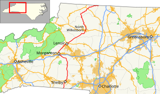
North Carolina Highway 18 (NC 18) is a primary state highway in the U.S. state of North Carolina. Traveling north–south through the Foothills region, it connects the cities of Shelby, Morganton, Lenoir, Wilkesboro and North Wilkesboro.

North Carolina Highway 143 (NC 143) is a primary state highway in the U.S. state of North Carolina. It runs from the Tennessee state line to NC 28, near the community of Stecoah. It is best known for its 18-mile (29 km) section of the Cherohala Skyway, shared with Tennessee State Route 165.
U.S. Route 70 (US 70) is a part of the United States Numbered Highway System that runs from Globe, Arizona, to the Crystal Coast of the US state of North Carolina. In North Carolina, it is a major 488-mile-long (785 km) east–west highway that runs from the Tennessee border to the Atlantic Ocean. From the Tennessee state line near Paint Rock to Asheville it follows the historic Dixie Highway, running concurrently with US 25. The highway connects several major cities including Asheville, High Point, Greensboro, Durham, Raleigh, Goldsboro, and New Bern. From Beaufort on east, US 70 shares part of the Outer Banks Scenic Byway, a National Scenic Byway, before ending in the community of Atlantic, located along Core Sound.
U.S. Route 421 (US 421) is part of the United States Numbered Highway System that runs from Fort Fisher, North Carolina to Michigan City, Indiana. In the U.S. state of North Carolina, US 421 travels 328 miles (528 km) from its southern terminus at Fort Fisher to the Tennessee state line near the community of Zionville, North Carolina. US 421 traverses the state from east to west travelling from the coastal plains to Appalachian Mountains. It provides an important connection between the cities of Wilmington, Sanford, Greensboro, Winston-Salem, and Boone. Despite being signed as north-south, much of the routing of US 421 in North Carolina runs in an east-west direction, particularly between Greensboro and the Tennessee state line. Portions of US 421 have been upgraded to freeway standards including the majority of its routing between Sanford and North Wilkesboro.
Interstate 26 (I-26) in North Carolina runs through the western part of the state from the Tennessee border to the South Carolina border, following the Appalachian Mountains. It is part of the larger I-26, a regional Interstate that runs from Kingsport, Tennessee, to Charleston, South Carolina. I-26 is mostly four lanes through North Carolina with few exceptions. Though signed with east–west cardinal directions, in North Carolina and Tennessee, the route goes nearly north–south, with the northern direction labeled "West" and vice versa.
U.S. Route 19 (US 19) traverses 145 miles (233 km) across Western North Carolina; from the Georgia state line, at the community of Bellview, to Cane River, where US 19 splits into US 19E and US 19W, which take separate routes into Tennessee.
U.S. Route 25 (US 25) is a north–south United States highway that runs for 75.4 miles (121.3 km) from the South Carolina state line, near Tuxedo, to the Tennessee state line, near Hot Springs. It is part of the longer U.S. Route 25, which runs from Brunswick, Georgia to Covington, Ohio. It is a major north-south route through Western North Carolina.

In the U.S. state of North Carolina U.S. Route 221 (US 221) is a north–south highway that travels through Western North Carolina. From Chesnee, South Carolina to Independence, Virginia, it connects the cities of Rutherfordton, Marion, Boone and Jefferson between the two out-of-state destinations. Its most memorable section, known as the Little Parkway Scenic Byway between Linville and Blowing Rock, offers area visitors a curvier alternative to the Blue Ridge Parkway and access to Grandfather Mountain.

North Carolina Highway 181 (NC 181) is a primary state highway in the U.S. state of North Carolina. It runs north–south from Morganton to Newland.

North Carolina Highway 80 (NC 80) is a primary state highway in the U.S. state of North Carolina. The highway connects the various mountain communities straddled along Buck Creek, South Toe River and North Toe River in Western North Carolina and serves as a direct route, via the Blue Ridge Parkway, to Mount Mitchell State Park.

North Carolina Highway 191 (NC 191) is a primary state highway in the U.S. state of North Carolina. It travels within portions of Henderson and Buncombe Counties.
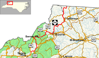
North Carolina Highway 194 (NC 194) is a primary state highway in the U.S. state of North Carolina. Entirely in the High Country, it runs from US 19E, in Ingalls, to the Virginia state line, near Helton.
Several special routes of U.S. Route 74 exist. In order from west to east they are as follows.

North Carolina Highway 63 (NC 63) is a primary state highway in the U.S. state of North Carolina. The highway runs east–west, connecting western Madison County with Asheville.


