
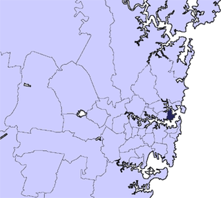
Sydney is the capital city of the state of New South Wales and the most populous city in Australia. Located on Australia's east coast, the metropolis surrounds Sydney Harbour and extends about 80 km from the Pacific Ocean in the east to the Blue Mountains in the west, and about 80 km from the Ku-ring-gai Chase National Park and the Hawkesbury River in the north and north-west, to the Royal National Park and Macarthur in the south and south-west. Greater Sydney consists of 658 suburbs, spread across 33 local government areas. Residents of the city are colloquially known as "Sydneysiders". The estimated population in June 2023 was 5,450,496, which is about 66% of the state's population. The city's nicknames include the "Emerald City" and the "Harbour City".

Ku-ring-gai Chase National Park is a national park on the northern side of Sydney in New South Wales, Australia. The 14,977-hectare (37,010-acre) park is 25 kilometres (16 mi) north of the Sydney central business district and generally comprises the land east of the M1 Pacific Motorway, south of the Hawkesbury River, west of Pittwater and north of Mona Vale Road. It includes Barrenjoey Headland on the eastern side of Pittwater.

The Sydney Harbour National Park is an Australian national park comprising parts of Port Jackson, Sydney and its foreshores and various islands. The 392-hectare (970-acre) national park lies in New South Wales and was created progressively, from 1975.

Port Jackson, consisting of the waters of Sydney Harbour, Middle Harbour, North Harbour and the Lane Cove and Parramatta Rivers, is the ria or natural harbour of Sydney, New South Wales, Australia. The harbour is an inlet of the Tasman Sea. It is the location of the Sydney Opera House and Sydney Harbour Bridge. The location of the first European settlement and colony on the Australian mainland, Port Jackson has continued to play a key role in the history and development of Sydney.

St Leonards is a suburb on the lower North Shore of Sydney, Australia. St Leonards is located 5 km (3.1 mi) north-west of the Sydney central business district and lies across the local government areas of Municipality of Lane Cove, North Sydney Council and the City of Willoughby.
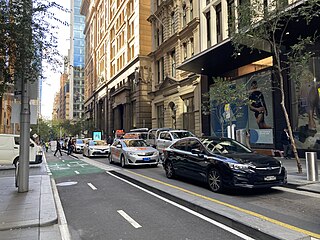
Pitt Street is a major street in the Sydney central business district in New South Wales, Australia. The street runs through the entire city centre from Circular Quay in the north to Waterloo, although today's street is in two disjointed sections after a substantial stretch of it was removed to make way for Sydney's Central railway station. Pitt Street is well known for the pedestrian only retail centre of Pitt Street Mall, a section of the street which runs from King Street to Market Street.

Manly is a beach-side suburb of northern Sydney, in the state of New South Wales, Australia. It is 17 kilometres (11 mi) north-east of the Sydney central business district and is currently one of the three administrative centres of the local government area of Northern Beaches Council. Manly has a long-standing reputation as a tourist destination, owing to its attractive setting on the Pacific Ocean and easy accessibility by ferry.

The Mid North Coast is a country region in the north-east of the state of New South Wales, Australia. The region, situated 416km north of Sydney, covers the mid northern coast of the state, beginning from Port Stephens at Hawks Nest to as far north as Woolgoolga, near Coffs Harbour. The region has many beaches and subtropical national parks and forests as well as rural farmland and logging. Major coastal towns include Coffs Harbour, Forster and Port Macquarie. The Mid North Coast is a popular destination for camping or resorts and surfing, with coastal and hinterland tracks, with the unique heritage-listed mountain village of Bellbrook popular for day trips inland or 4wd campers and keen bass fishers.

Paddington is an upscale Eastern Suburb of Sydney, in the state of New South Wales, Australia. Located 3 kilometres (1.9 mi) east of the Sydney central business district, Paddington lies across two local government areas. The portion south of Oxford Street lies within the City of Sydney, while the portion north of Oxford Street lies within the Municipality of Woollahra. It is often colloquially referred to as "Paddo".

Watsons Bay is a harbourside, eastern suburb of Sydney, in the state of New South Wales, Australia. Watsons Bay is located 11 km north-east of the Sydney central business district, in the local government area of the Municipality of Woollahra.

Balmoral is an urban locality in the suburb of Mosman in Sydney, New South Wales, Australia. It is in the local government area of the Municipality of Mosman and is part of the Lower North Shore.
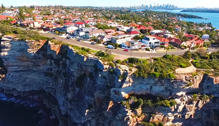
Vaucluse is an eastern suburb of Sydney, in the state of New South Wales, Australia. It is located 8 kilometres (5 mi) east of the Sydney central business district, in the local government areas of Waverley Council and the Municipality of Woollahra.

Waverton is a harbour-side suburb on the lower North Shore of Sydney, New South Wales, Australia. Waverton is 4 kilometres north of the Sydney central business district, in the local government area of North Sydney Council.
Mosman Council is a local government area on the Lower North Shore of Sydney, New South Wales, Australia.

Pittwater is a semi-mature tide dominated drowned valley estuary, located about 40 kilometres (25 mi) north of the Sydney central business district, New South Wales, Australia; being one of the bodies of water that separate greater Metropolitan Sydney from the Central Coast.

The Sydney Heads are a series of headlands that form the 2 km (1.2 mi) wide entrance to Sydney Harbour in Sydney, New South Wales, Australia. North Head and Quarantine Head are to the north; South Head and Dunbar Head are to the south; and Middle Head, Georges Head, and Chowder Head are to the west and within the harbour. The Heads are contained within the Sydney Harbour National Park.

Bradleys Head is a headland protruding from the north shore of Sydney Harbour, within the metropolitan area of Sydney, New South Wales, Australia. It is named after the First Fleet naval officer William Bradley. The original Aboriginal inhabitants, who belonged to the Borogegal clan of the Eora nation, knew Bradleys Head as Borogegy, Booraghee, Booragy or Burrogy. On the headland is an active lighthouse, Bradleys Head Light, constructed in 1905.

Mosman is a suburb on the Lower North Shore region of Sydney, in the state of New South Wales, Australia. Mosman is located 8 kilometres north-east of the Sydney central business district and is the administrative centre for the local government area of the Municipality of Mosman.

The Bradleys Head Light is an active heritage-listed lighthouse at Bradleys Head, a headland protruding from the north shore of Sydney Harbour in the suburb of Mosman, New South Wales, Australia. It is the sibling of Robertson Point Light. The site is owned and managed as part of the Sydney Harbour National Park by the NSW National Parks and Wildlife Service, an agency of the Government of New South Wales; while the light is managed and operated by Sydney Ports Corporation. It was added to the New South Wales State Heritage Register on 18 April 2000.
Balls Head Bay, formerly known as Oyster Cove, Wollstonecraft Bay,Sugarworks Bay, Powder Works Bay and Kerosene Bay, is a bay located to the west of the Waverton Peninsula, west of Balls Head and to the east of Berry Island, on the north of Sydney Harbour, Sydney, New South Wales, Australia.

