
Childe's Tomb is a granite cross on Dartmoor, Devon, England. Although not in its original form, it is more elaborate than most of the crosses on Dartmoor, being raised upon a constructed base, and it is known that a kistvaen is underneath.

Dartmoor is an upland area in southern Devon, South West England. The moorland and surrounding land has been protected by National Park status since 1951. Dartmoor National Park covers 954 km2 (368 sq mi).
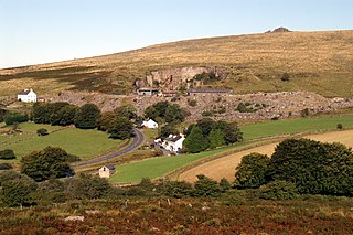
Princetown is a village located within Dartmoor national park in the English county of Devon. It is the principal settlement of the civil parish of Dartmoor Forest.

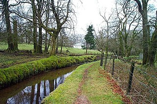
The Devonport Leat is a leat in Devon constructed in the 1790s to carry fresh drinking water from the high ground of Dartmoor to the expanding dockyards at Plymouth Dock.

BBC Radio Devon is the BBC's local radio station serving the county of Devon.

The Walkham is a river whose source is on Dartmoor, Devon, England. It rises in the wide gap between Roos Tor and Great Mis Tor and flows almost due south for approximately 3 miles (4.8 km) leaving the tors and thus National Park behind then south-west for 1 mile (1.6 km) past Woodtown. The river then reaches a village, Horrabridge, with a small compact network of streets mainly on the south or left bank. It receives most of its tributaries which are unnamed headwaters along its south-flowing inception, draining the near side of two series of six tors (peaks) to the west ending in Pew Tor at 320 metres and likewise to the east ending in Leeden Tor at 389 metres. In absolute distance, 2 miles (3.2 km) west of the village and the same south of the small well-preserved town of Tavistock by a footbridge on the West Devon Way the Walkham joins the Tavy which discharges into the Tamar Estuary north of the Plymouth conurbation after a fast descent around wide hillsides, a few miles south.
Merrivale is a locality in western Dartmoor, in the West Devon district of Devon, England. It is best known for the nearby series of Bronze Age megalithic monuments to the south and a former granite quarry.

Dartmeet is a popular tourist spot in the centre of Dartmoor, Devon, England at grid reference SX672731.

Belstone is a small village and civil parish in the West Devon District of Devon, England.

The Pontop Pike transmitting station is a facility for telecommunications and broadcasting situated on a 312-metre (1,024-ft) high hill of the same name between Stanley and Consett, County Durham, near the village of Dipton, England. The mast is 149 metres (489 ft) high, giving an average antenna height of 461 metres (1,512 ft) above sea level. It is owned and operated by Arqiva.

The Caradon Hill transmitting station is a broadcasting and telecommunications facility on Bodmin Moor in the civil parish of Linkinhorne, located on Caradon Hill, Cornwall, England, United Kingdom. It is 4 miles (6.4 km) north of Liskeard, and 3⁄4 mile (1.2 km) south-east of Minions, the highest village in Cornwall. Built in 1961, the station includes a 237.7 metres (780 ft) guyed steel lattice mast. The mean height for the television antennas is 603 metres (1,978 ft) above sea level. The site has a smaller towers used for telecommunications and a wireless internet signal. It is owned and operated by Arqiva.
Arqiva is a British telecommunications company which provides infrastructure, broadcast transmission and smart meter facilities in the United Kingdom. The company is headquartered at the former Independent Broadcasting Authority headquarters at Crawley Court in the village of Crawley, Hampshire, just outside Winchester. Its main customers are broadcasters and utility companies, and its main asset is a network of circa. 1,500 radio and television transmission sites. It is owned by a consortium of investors led by Digital 9 Infrastructure and the Australian investment house Macquarie Bank. Arqiva is a patron of the Radio Academy.

The Rowridge transmitting station is a facility for FM radio and television transmission at Rowridge on the Isle of Wight in southern England.
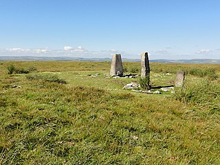
At 515 m, Ryder's Hill is the highest point on the southern part of Dartmoor, Devon, England. On its summit there are two standing stones and a low cairn, on top of which is a triangulation pillar.
Dartmoor Forest is a civil parish in Devon, England. It was formed in 1987 by the splitting of the former parish of Lydford. It covers about 56,000 acres (230 km2) entirely within Dartmoor National Park, and is the largest parish in Devon. Despite its size its population in 2001 was only 1,619. Due to its large size it is surrounded by many other parishes: these are, clockwise from the north, Belstone, South Tawton, Throwleigh, Gidleigh, Chagford, North Bovey, Manaton, Widecombe in the Moor, Holne, West Buckfastleigh, Dean Prior, South Brent, Ugborough, Harford, Cornwood, Shaugh Prior, Sheepstor, Walkhampton, Whitchurch, Peter Tavy, Lydford, land common to the parishes of Bridestowe and Sourton, and Okehampton Hamlets.
Tor Royal is a Grade II listed building near Princetown, Dartmoor, in the English county of Devon. Built between 1785 and 1793 by Sir Thomas Tyrwhitt, it was added to in c.1815–20, and restored by A. E. Richardson in 1912.
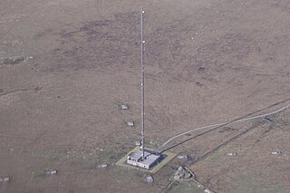
Standing on the summit of North Hessary Tor in Devon, England is an FM radio and television transmitter which uses as aerial a 196 metres (643 ft) high guyed mast.
Rippon Tor is a striking tor on eastern Dartmoor, in England, that stands at 473 metres (1,552 ft) above sea level. It has three cairns, of which are some of Dartmoor's largest, a triangulation pillar, and several rock piles that overlook the northern high moors near Fernworthy Forest and Great Mis Tor. Field boundaries surround the tor.
Skylark is a community radio station in the Dartmoor National Park, in Devon, United Kingdom. It was founded in 2020 by the operators of another community radio station, Soundart Radio in nearby Dartington following a successful crowdfunding scheme.
