
Alaska is a non-contiguous U.S. state on the northwest extremity of North America. It is in the Western United States region. The only other non-contiguous U.S. state is Hawaii. Alaska is also considered to be the northernmost, westernmost, and easternmost state in the United States. It borders the Canadian territory of Yukon and the province of British Columbia to the east. It shares a western maritime border, in the Bering Strait, with Russia's Chukotka Autonomous Okrug. The Chukchi and Beaufort Seas of the Arctic Ocean lie to the north, and the Pacific Ocean lies to the south. Technically, it is a semi-exclave of the U.S., and is the largest exclave in the world.

Southeast Alaska, often abbreviated to southeast or southeastern, and sometimes called the Alaska(n) panhandle, is the southeastern portion of the U.S. state of Alaska, bordered to the east and north by the northern half of the Canadian province of British Columbia. The majority of southeast Alaska is situated in Tlingit Aaní, much of which is part of the Tongass National Forest, the United States' largest national forest. In many places, the international border runs along the crest of the Boundary Ranges of the Coast Mountains. The region is noted for its scenery and mild, rainy climate.

The Bering Sea is a marginal sea of the Northern Pacific Ocean. It forms, along with the Bering Strait, the divide between the two largest landmasses on Earth: Eurasia and the Americas. It comprises a deep water basin, which then rises through a narrow slope into the shallower water above the continental shelves. The Bering Sea is named after Vitus Bering, a Danish-born Russian navigator, who, in 1728, was the first European to systematically explore it, sailing from the Pacific Ocean northward to the Arctic Ocean.

The contiguous United States consists of the 48 adjoining U.S. states and the District of Columbia of the United States in central North America. The term excludes the only two non-contiguous states, which are Alaska and Hawaii, and all other offshore insular areas, such as the U.S. territories of American Samoa, Guam, the Northern Mariana Islands, Puerto Rico, and the U.S. Virgin Islands. The colloquial term "Lower 48" is also used, especially in relation to Alaska.

Juneau, officially the City and Borough of Juneau, is the capital of the U.S. state of Alaska, located along the Gastineau Channel and the Alaskan panhandle. Juneau was named the capital of Alaska in 1906, when the government of what was then the District of Alaska was moved from Sitka as dictated by the U.S. Congress in 1900. On July 1, 1970, the City of Juneau merged with the City of Douglas and the surrounding Greater Juneau Borough to form the current consolidated city-borough, which ranks as the second-largest municipality in the United States by area and is larger than either Rhode Island or Delaware.

Kodiak Island Borough is a borough in the U.S. state of Alaska. At the 2020 census, the population was 13,101, down from 13,592 in 2010. The borough seat is Kodiak.

Sitka is a unified city-borough in the southeast portion of the U.S. state of Alaska. It was under Russian rule from 1799 to 1867. The city is situated on the west side of Baranof Island and the south half of Chichagof Island in the Alexander Archipelago of the Pacific Ocean. As of the 2020 census, Sitka had a population of 8,458, making it the fifth-most populated city in the state.

In the United States, a county or county equivalent is an administrative or political subdivision of a U.S. state or other territories of the United States which consists of a geographic area with specific boundaries and usually some level of governmental authority. The term "county" is used in 48 states, while Louisiana and Alaska have functionally equivalent subdivisions called parishes and boroughs, respectively. Counties and other local governments exist as a matter of U.S. state law, so the specific governmental powers of counties may vary widely between the states, with many providing some level of services to civil townships, municipalities, and unincorporated areas. Certain municipalities are in multiple counties; New York City is uniquely partitioned into five counties, referred to at the city government level as boroughs. Some municipalities have been consolidated with their county government to form consolidated city-counties, or have been legally separated from counties altogether to form independent cities. Conversely, counties in Connecticut and Rhode Island, eight of Massachusetts's 14 counties, and Alaska's Unorganized Borough have no government power, existing only as geographic distinctions.

The City of Unalaska is the main population center in the Aleutian Islands. The city is in the Aleutians West Census Area, a regional component of the Unorganized Borough in the U.S. state of Alaska. Unalaska is located on Unalaska Island and neighboring Amaknak Island in the Aleutian Islands off mainland Alaska. The population was 4,254 at the 2020 census, which is 81% of the entire Aleutians West Census Area. Unalaska is the second largest city in the Unorganized Borough, behind Bethel.
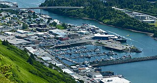
The City of Kodiak is the main city and one of seven communities on Kodiak Island in Kodiak Island Borough, Alaska. All commercial transportation between the island's communities and the outside world goes through this city via ferryboat or airline. As of the 2020 census, the population of the city is 5,581, down from 6,130 in 2010. It is the tenth-largest city in Alaska.

Unimak Island is the largest island in the Aleutian Islands chain of the U.S. state of Alaska.

Kodiak Island is a large island on the south coast of the U.S. state of Alaska, separated from the Alaska mainland by the Shelikof Strait. The largest island in the Kodiak Archipelago, Kodiak Island is the second largest island in the United States and the 80th largest island in the world, with an area of 3,595.09 sq mi (9,311.2 km2), slightly larger than Cyprus. It is 160 km long and in width ranges from 16 to 97 kilometers. Kodiak Island is the namesake for Kodiak Seamount, which lies off the coast at the Aleutian Trench. The largest community on the island is the city of Kodiak, Alaska.

The Gulf of Alaska is an arm of the Pacific Ocean defined by the curve of the southern coast of Alaska, stretching from the Alaska Peninsula and Kodiak Island in the west to the Alexander Archipelago in the east, where Glacier Bay and the Inside Passage are found.

The Aleutian Trench is an oceanic trench along a convergent plate boundary which runs along the southern coastline of Alaska and the Aleutian islands. The trench extends for 3,400 kilometres (2,100 mi) from a triple junction in the west with the Ulakhan Fault and the northern end of the Kuril–Kamchatka Trench, to a junction with the northern end of the Queen Charlotte Fault system in the east. It is classified as a "marginal trench" in the east as it runs along the margin of the continent. The subduction along the trench gives rise to the Aleutian Arc, a volcanic island arc, where it runs through the open sea west of the Alaska Peninsula. As a convergent plate boundary, the trench forms part of the boundary between two tectonic plates. Here, the Pacific plate is being subducted under the North American plate at a dip angle of nearly 45°. The rate of closure is 7.5 centimetres (3 in) per year.

The Eleventh Air Force (11 AF) is a Numbered Air Force of the United States Air Force Pacific Air Forces (PACAF). It is headquartered at Joint Base Elmendorf–Richardson, Alaska.
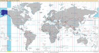
UTC−09:00 is an identifier for a time offset from UTC of −09:00. This time is used in:
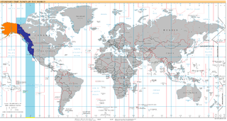
UTC−08:00 is an identifier for a time offset from UTC of −08:00. This time is used:

The Aleutian Islands —also called the Aleut Islands, Aleutic Islands, or, before 1867, the Catherine Archipelago—are a chain of 14 main, larger volcanic islands and 55 smaller ones. Most of the Aleutian Islands belong to the U.S. state of Alaska, with the archipelago encompassing the Aleutians West Census Area and the Aleutians East Borough. The Commander Islands, located further to the west, belong to the Russian federal subject of Kamchatka Krai, of the Russian Far East. The islands form part of the Aleutian Arc of the Northern Pacific Ocean, and occupy a land area of 6,821 sq mi (17,666 km2) that extends westward roughly 1,200 mi (1,900 km) from the Alaskan Peninsula mainland, in the direction of the Kamchatka Peninsula; the archipelago acts as a border between the Bering Sea to the north and the Pacific Ocean to the south. Crossing longitude 180°, at which point east and west longitude end, the archipelago contains both the westernmost and easternmost parts of the United States, by longitude. The westernmost U.S. island, in real terms, however, is Attu Island, west of which runs the International Date Line.
