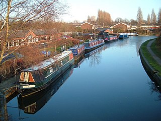
The Wyrley and Essington Canal, known locally as "the Curly Wyrley", is a canal in the English Midlands. As built it ran from Wolverhampton to Huddlesford Junction near Lichfield, with a number of branches: some parts are currently derelict. Pending planned restoration to Huddlesford, the navigable mainline now terminates at Ogley Junction near Brownhills. In 2008 it was designated a Local Nature Reserve.

Brownhills is a historic market and industrial town in the Metropolitan Borough of Walsall of the West Midlands, England. The town is located south of Cannock Chase and close to the large Chasewater reservoir, it is 6 miles (9.7 km) northeast of Walsall, a similar distance southwest of Lichfield and 13 miles (20.9 km) miles north-northwest of Birmingham. It is part of the Aldridge-Brownhills parliamentary constituency and neighbours the villages of Pelsall and Walsall Wood. It lies within the boundaries of the historic county of Staffordshire.

Burntwood is a former mining town and civil parish in the Lichfield District of Staffordshire, England. It is approximately 4 miles (6 km) west of Lichfield and north east of Brownhills, with a population of 26,049 and forming part of Lichfield district. The town forms one of the largest urbanised parishes in England. Samuel Johnson opened an academy in nearby Edial in 1736. The town is home to the smallest park in the UK, Prince's Park, which is located next to Christ Church on the junction of Farewell Lane and Church Road. The town expanded in the nineteenth century around the coal mining industry.
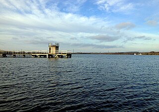
Chasewater is a reservoir located in the parish of Burntwood and the district of Lichfield in Staffordshire, England. Originally known as Norton Pool and Cannock Chase Reservoir, it was created as a canal feeder reservoir in 1797. The reservoir was created to directly supply the Wyrley and Essington Canal and maintain levels in the 160-mile (260 km) Birmingham Canal Network. During a period of great industrial growth in the Black Country region the maintenance of water levels in canal infrastructure was essential and Chasewater was in great demand. As canals became less essential for transport of goods during the mid-20th century, the reservoir diversified and became a popular public amenity with activities such as water-skiing, sailing, wakeboarding and cycling. Chasewater is the third largest reservoir by volume in the county of Staffordshire and the largest canal feeder reservoir in the West Midlands.
Cannock Chase is a local government district in Staffordshire, England. It is named after and covers a large part of Cannock Chase, a designated National Landscape. The council is based in the town of Cannock. The district also contains the towns of Hednesford and Rugeley, as well as a number of villages and surrounding rural areas.

The Chasewater Railway is a former colliery railway running round the shores of Chasewater in Staffordshire, England. It is now operated as a heritage railway.

The Hatherton Canal is a derelict branch of the Staffordshire and Worcestershire Canal in south Staffordshire, England. It was constructed in two phases, the first section opening in 1841 and connecting the main line to Churchbridge, from where a tramway connected to the Great Wyrley coal mines. The second section was a joint venture with the Birmingham Canal Navigations, and linked Churchbridge to the Cannock Extension Canal by a flight of 13 locks, which were opened with the Extension Canal in 1863. The coal traffic was very profitable, and the canal remained in use until 1949. It was formally abandoned in 1955, after which the Churchbridge flight and much of the Extension Canal were destroyed by open cast mining.

Great Wyrley is a village and civil parish in the South Staffordshire district of Staffordshire, England. It forms a built up area with nearby Cheslyn Hay, Churchbridge, Landywood and Little Wyrley. It lies 6 miles north of Walsall and a similar distance from Wolverhampton. Cannock is directly north of the village. It had a population of 11,060 at the 2011 census.

Pelsall is a village in the Metropolitan Borough of Walsall, West Midlands, England. Forming part of the borough's border with Staffordshire, Pelsall is located 4 miles north of Walsall, midway between the towns of Bloxwich and Brownhills and 4 miles northwest of Aldridge. The southern edge of Cannock Chase is 6 miles to the north. Pelsall is also 8 miles southwest of Lichfield and 8 miles northeast of Wolverhampton.
The South Staffordshire Railway (SSR) was authorised in 1847 to build a line from Dudley in the West Midlands of England through Walsall and Lichfield to a junction with the Midland Railway on the way to Burton upon Trent, with authorised share capital of £945,000. It was supported by the newly-formed London and North Western Railway (LNWR) and the Midland Railway, giving each company access to important areas. It completed its main line in 1849. As collieries in the Cannock region rose in importance, it built a second main line from Walsall to Rugeley, as well as numerous short spurs and connections to lines it intersected. Colliery working in the Cannock area expanded enormously, and mineral traffic carryings increased in step.

Norton Canes is an industrial village, civil parish and ward of Cannock Chase District, in Staffordshire, England.

The current Cannock Extension Canal is a 1.8-mile (2.9 km) canal in England. It runs from Pelsall Junction on the Wyrley and Essington Canal, north to Norton Canes Docks and forms part of the Birmingham Canal Navigations. Historically, it ran to Hednesford, and served a number of collieries, which provided the main traffic. It opened in 1863, and the northern section closed in 1963, as a result of mining subsidence.

Huddlesford Junction is a canal junction at the original north-eastern limit of the Wyrley and Essington Canal where it met the Coventry Canal, near Lichfield, in Staffordshire, England.

Pelsall Junction is a canal junction at the southern limit of the Cannock Extension Canal where it meets the Wyrley and Essington Canal main line, near Pelsall, West Midlands, England.

Rumer Hill Junction was a canal junction on the Cannock Extension Canal where the Churchbridge Branch left to join the Hatherton Canal. The junction, along with the northern section of the canal was abandoned in 1963. The Churchbridge Branch and Rumer Hill Junction were subsequently obliterated by opencast mining.

Little Wyrley is a hamlet in the Cannock Chase district, in the county of Staffordshire, England. It forms part of Norton Canes. In 1870-72 it had a population of 61 as recorded in the Imperial Gazetteer of England and Wales.
Norton Canes is a civil parish in the district of Cannock Chase, Staffordshire, England. It contains three buildings that are recorded in the National Heritage List for England. Of these, two are listed at Grade II*, the middle grade, and the other is at Grade II, the lowest grade. The parish contains the villages of Norton Canes and Little Wyrley, and is otherwise rural. The listed buildings are a country house and an associated barn, and a church.

The Cannock Chase Railways were mineral lines which served the collieries and many parts of Staffordshire. The branch lines and sidings branched off the local mainlines including the Grand Junction Railway, Chase Line, South Staffordshire Line and Rugby–Birmingham–Stafford line. The main junction on the railways was Norton Junction. This junction connected the lines from Walsall and Hednesford to Wolverhampton and Rugeley Trent Valley for the local collieries and the mines in the towns of Brownhills, Burntwood, Chasetown, Penkridge and Cannock.

Grove Colliery was a colliery in North Lanes, Staffordshire. Located between the villages of Pelsall and Norton Canes. It opened in 1852 as Wyrley Grove Colliery. It was served by barges on the Cannock Extension Canal until the arrival of a mineral line from Norton Junction. In 1930, a mining explosion occurred which killed 14 miners.

