
Accra is the capital and largest city of Ghana, located on the southern coast at the Gulf of Guinea, which is part of the Atlantic Ocean. As of 2021 census, the Accra Metropolitan District, 20.4 km2 (7.9 sq mi), had a population of 284,124 inhabitants, and the larger Greater Accra Region, 3,245 km2 (1,253 sq mi), had a population of 5,455,692 inhabitants. In common usage, the name "Accra" often refers to the territory of the Accra Metropolitan District as it existed before 2008, when it covered 199.4 km2 (77.0 sq mi). This territory has since been split into 13 local government districts: 12 independent municipal districts and the reduced Accra Metropolitan District (20.4 km2), which is the only district within the capital to be granted city status. This territory of 199.4 km2 contained 1,782,150 inhabitants at the 2021 census, and serves as the capital of Ghana, while the district under the jurisdiction of the Accra Metropolitan Assembly proper (20.4 km2) is distinguished from the rest of the capital as the "City of Accra".

The Palisades, or simply Palisades, is a neighborhood in Washington, D.C., along the Potomac River, running roughly from the edge of the Georgetown University campus to the D.C.-Maryland boundary.

Queenstown is a planning area and satellite residential town situated on the south-westernmost fringe of the Central Region of Singapore. It borders Bukit Timah to the north, Tanglin to the northeast, Bukit Merah to the east and southeast, as well as Clementi to the northwest and west. Its southern and southwesternmost limits are bounded by the Pandan Strait.

Bayview Village is a neighbourhood in Toronto, Ontario, Canada. It is part of the federal Don Valley North riding and the provincial Don Valley North electoral district, and Toronto electoral Ward 17: Don Valley North. In 2006, it had a population of 15,370.

Massachusetts Avenue is a major diagonal transverse road in Washington, D.C., and the Massachusetts Avenue Historic District is a historic district that includes part of it.
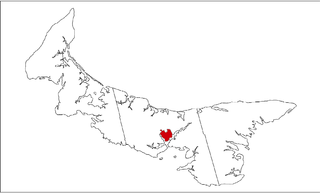
There are various neighbourhoods within the Canadian city of Charlottetown, Prince Edward Island.

Located about 3 kilometres (1.9 mi) east of the central business district, Osu is a neighborhood in central Accra, Ghana, West Africa. It is locally known as the "West End" of Accra. Bounded to the south by the Gulf of Guinea, Osu's western boundary is the Independence Avenue. Osu is separated from the northern district of Labone by Ring Road. Due to its establishment as a settlement in the 17th century, Osu has a mix of houses dating from the early 20th century and modern office towers.
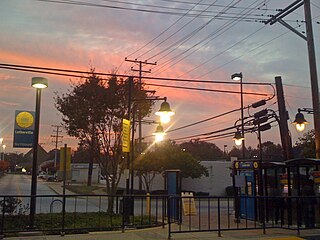
Lutherville is a census-designated place (CDP) in Baltimore County, Maryland, United States. As of the 2010 census it had a population of 6,504. Prior to 2010 the area was part of the Lutherville-Timonium CDP. Within its borders lies the Lutherville Historic District.

Don Valley Village is a neighbourhood in the city of Toronto, Ontario, Canada. It is located in the former suburb of North York. Located north of Highway 401 and bisected by Don Mills Road, it is bounded by Sheppard Avenue to the south, Leslie Street to the west, Finch Avenue to the north and Highway 404 to the east. Like the nearby Don River Valley, the neighbourhood has hill and dale topography.

Ablekuma South is one of the constituencies represented in the Parliament of Ghana. It elects one Member of Parliament (MP) by the first past the post system of election. Ablekuma South is located in the Accra Metropolitan Area of the Greater Accra Region of Ghana. It is one of the three sub metropolitan district councils of Accra Metropolitan Assembly.

Holland Park Avenue is a street located in the Royal Borough of Kensington and Chelsea, in west central London. The street runs from Notting Hill Gate in the east to the Holland Park Roundabout in the west, forms a part of the old west road connecting London with Oxford and the west of England, and is designated part of the A402 road.
Armour Heights is a neighbourhood in Toronto, Ontario, Canada, in the district of North York. It is bounded by Wilson Avenue to the south, Bathurst Street to the west, and the west branch of the Don River to the north and east. Highway 401 cuts through the centre of the neighbourhood.

Oakwood Village, formerly known as Oakwood–Vaughan, is a neighbourhood in Toronto, Ontario, Canada. Located in the former suburb of York, the neighbourhood is a Business Improvement Area (BIA); it has an annual arts festival and a public library built in 1997.

West Ridge is a neighbourhood of Accra, Ghana, bounded to the south by Kinbu Gardens. Barnes Road serves as the neighbourhood's western boundary, while the Independence Avenue/Liberation Avenue is the eastern boundary. Castle Road separates West Ridge from the northern neighbourhood of North Ridge. The Accra branch of the British Council is located in West Ridge, off Liberia Road.
East Ridge is a neighborhood of Accra, Ghana bounded to the south and East by Sir Charles Quist Street. Independence Avenue serves as the district's western boundary. Castle Road separates East Ridge from the northern neighborhood of Osu.

The city of Accra, capital of Ghana, is officially divided into five geographical regions: North, West, East, Central and south - and eleven sub-metropolitan areas: Osu Klottey, Ablekuma North, Ablekuma South, Ayawaso Central, Ayawaso East, Ayawaso North, Ayawaso West, La, Okaikoi North, Okaikoi South, Abossey Okai, and Ashiedu Keteke. The word "neighbourhood" can take on various official and unofficial meanings. There are, however, 50 official neighbourhoods within the city limits of Accra.
Spring Park is a Canadian neighbourhood in the city of Charlottetown, Prince Edward Island.


