Related Research Articles
Columbia is a town in Washington County, Maine, United States. The population was 435 at the 2020 census. According to the United States Census Bureau, the town has a total area of 36.61 square miles (94.82 km2), of which, 36.30 square miles (94.02 km2) of it is land and 0.31 square miles (0.80 km2) is water.
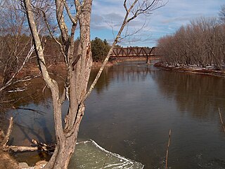
The Saco River is a river in northeastern New Hampshire and southwestern Maine in the United States. It drains a rural area of 1,703 square miles (4,410 km2) of forests and farmlands west and southwest of Portland, emptying into the Atlantic Ocean at Saco Bay, 136 miles (219 km) from its source. It supplies drinking water to roughly 250,000 people in thirty-five towns; and historically provided transportation and water power encouraging development of the cities of Biddeford and Saco and the towns of Fryeburg and Hiram. The name "Saco" comes from the Eastern Abenaki word [sɑkohki], meaning "land where the river comes out". The Jesuit Relations, ethnographic documents from the 17th century, refer to the river as Chouacoet.

Saco Bay is a small curved embayment of the Gulf of Maine on the Atlantic coast of Maine in the United States. The name derives "from a map of the coastline made in 1525 by the Spanish explorer Esteban Gómez. He named the bay Bahio de Saco ."

Interstate 195 (I-195), also known as the Saco Industrial Spur, is a short auxiliary Interstate Highway running 1.55 miles (2.49 km) in eastern York County, Maine. The highway, located entirely in the city of Saco, is a nominally east–west route that provides access to downtown Saco and the resort town of Old Orchard Beach from I-95. The western terminus of I-195 is at a trumpet interchange with the Maine Turnpike in central Saco. The route has numbered interchanges with Industrial Park Road, US Route 1 (US 1), and State Route 5 (SR 5) before terminating at an at-grade intersection with SR 5 near the border between Saco and Old Orchard Beach.

Interstate 95 (I-95) is a part of the Interstate Highway System that runs north–south from Miami, Florida to Houlton, Maine. The highway enters Maine from the New Hampshire state line in Kittery and runs for 303 miles (488 km) to the Canadian border in Houlton. It is the only primary Interstate Highway in Maine. In 2004, the highway's route between Portland and Gardiner was changed so that it encompasses the entire Maine Turnpike, a toll road running from Kittery to Augusta.

State Route 25 (SR 25) is part of the system of numbered highways in Maine. It runs for 42.4 miles (68.2 km) across the south central part of the state. SR 25 begins at the New Hampshire border near Porter, where it continues west as New Hampshire Route 25 (NH 25). Its eastern terminus is in downtown Portland at the intersection of Park Avenue and State Street. Administratively, it shares a terminus with SR 22 and SR 77.

The Presumpscot River is a 25.8-mile-long (41.5 km) river located in Cumberland County, Maine. It is the main outlet of Sebago Lake. The river provided an early transportation corridor with reliable water power for industrial development of the city of Westbrook and the village of South Windham.
Sean James Caisse is an American former stock car racing driver.

U.S. Route 1 (US 1) in the U.S. state of Maine is a major north–south U.S. Route serving the eastern part of the state. It parallels the Atlantic Ocean from New Hampshire north through Portland, Brunswick, and Belfast to Calais, and then the St. Croix River and the rest of the Canada–U.S. border via Houlton to Fort Kent. The portion along the ocean, known as the Coastal Route, provides a scenic alternate to Interstate 95 (I-95).

Scarborough River is a 3.7-mile-long (6.0 km) coastal estuary and river draining through the Scarborough Marsh in Scarborough, Maine. It empties into Saco Bay between Pine Point Beach and Western Beach and marks the bay's northern end. The main tributaries are the Nonesuch River, Dunstan River, and Libby River, as well as smaller brooks and streams.

Scarborough Marsh is a 3,200-acre saltwater marsh owned by the state of Maine and managed by the state's Department of Inland Fisheries and Wildlife as a wildlife management area. It is situated in southern Maine, in the town of Scarborough, in Cumberland County.
Scarborough is a town in Cumberland County on the southern coast of the U.S. state of Maine. Located about 7 miles (11 km) south of Portland, Scarborough is part of the Portland–South Portland–Biddeford, Maine metropolitan statistical area. The population was 22,135 at the 2020 census, making it the most populous town in Maine.

Wakonda State Park is a public recreation area covering 1,054 acres (427 ha) near La Grange in Lewis County, Missouri. The state park features water recreation on six small lakes.

State Route 112 (SR 112) is part of Maine's system of numbered state highways, running from SR 9 in Saco to SR 114 in Gorham. The 26-mile-long (42 km) route runs in a C-shape and is signed as north–south.
Beech Ridge Motor Speedway was a 1/3 mile NASCAR-sanctioned asphalt oval auto racing track in Scarborough, Maine. The track is located near the Scarborough Downs horse racing track.
West Scarborough is an area within the northwesternmost portion of the town of Scarborough, Maine.
Smiling Hill Farm is a 500 acre traditional New England farm encompassing parts of the municipalities of Westbrook, Scarborough, and Gorham, Maine. Founded in 1720 as the homestead of Nathaniel Knight, the 12th generation descendants continue to operate the farm today. Known as the "Knight Farm", the farm was renamed "Smiling Hill Farm" by Roger D. Knight in 1974. Roger named the farm after a favorite childhood book "Smiling Hill Farm" by Miriam E. Mason (1937). Smiling Hill Farm is known for its characteristic smiling cow logo. Smiling Hill Farm is the 9th oldest continually operating family business in the United States according to Family Business magazine.
Hancock Brook is an east-bank tributary to the Saco River at Hiram, Maine. The brook originates in eastern Denmark and flows through a chain of ponds along the border between Hiram and Sebago. The narrow-gauge Bridgton and Saco River Railroad was built along the brook in 1882, and operated until 1941.
State Route 703 (SR 703) is the designation of the Maine Turnpike Authority Approach Road, a 1.91-mile (3.07 km) road located in South Portland, Maine. It connects U.S. Route 1 (US 1) and State Route 9 to the Maine Turnpike, as well as I-295 and The Maine Mall. Except at its endpoints, it is a four-lane freeway with a 55-mile-per-hour (89 km/h) speed limit.

Pine Point Beach is a four-mile municipal beach located on the northern edge of Saco Bay in Scarborough, Maine, United States. It spans the outlet of the Scarborough River. It covers a total of just over three acres and has 7,000 feet of sandy ocean frontage. It also includes a sensitive sand dune system and a significant number of nearby commercial and residential buildings.
References
- ↑ "Online Significant Sand and Gravel Aquifers Maps". Maine Geological Survey. Retrieved June 1, 2015.
- ↑ "Online Significant Sand and Gravel Aquifers Maps (E - K)". Maine Geological Survey. Archived from the original on 2013-10-25. Retrieved June 1, 2015.
- ↑ Kelley, Michael (2013-10-18). "Grange hall was built to last: North Scarborough Grange celebrating 100th anniversary". Scarborough Leader. Scarborough, Maine: Mainely Media LLC. Archived from the original on June 1, 2015. Retrieved June 1, 2015.
| | This Maine state location article is a stub. You can help Wikipedia by expanding it. |