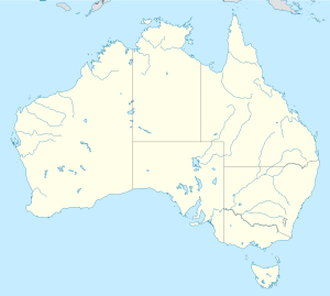
North West Twin Island
North West Twin Island on the map
North West Twin Island is an island in the Kimberley (Western Australia) . [1]
North West Twin Island is an island in the Kimberley (Western Australia) . [1]

The Tasman Sea is a marginal sea of the South Pacific Ocean, situated between Australia and New Zealand. It measures about 2,000 km (1,200 mi) across and about 2,800 km (1,700 mi) from north to south. The sea was named after the Dutch explorer Abel Janszoon Tasman, who in 1642 was the first known person to cross it. British explorer Lieutenant James Cook later extensively navigated the Tasman Sea in the 1770s during his three voyages of exploration.

The Montebello Islands, also rendered as the Monte Bello Islands, are an archipelago of around 174 small islands lying 20 km (12 mi) north of Barrow Island and 130 km (81 mi) off the Pilbara coast of north-western Australia. The islands form a marine conservation reserve of 58,331 ha administered by the Western Australian Department of Environment and Conservation. The islands were the site of three British atmospheric nuclear weapons tests in 1952 and 1956.
The Sulu Sea is a body of water in the southwestern area of the Philippines, separated from the South China Sea in the northwest by Palawan and from the Celebes Sea in the southeast by the Sulu Archipelago. Borneo is found to the southwest and Visayas to the northeast.
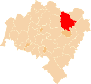
Trzebnica County is a unit of territorial administration and local government (powiat) in Lower Silesian Voivodeship, south-western Poland. It came into being on January 1, 1999, as a result of the Polish local government reforms passed in 1998. The county covers an area of 1,025.5 square kilometres (395.9 sq mi). Its administrative seat is Trzebnica, and it also contains the towns of Oborniki Śląskie, Żmigród and Prusice.

A pole of inaccessibility with respect to a geographical criterion of inaccessibility marks a location that is the most challenging to reach according to that criterion. Often it refers to the most distant point from the coastline, implying a maximum degree of continentality or oceanity. In these cases, a pole of inaccessibility can be defined as the center of the largest circle that can be drawn within an area of interest without encountering a coast. Where a coast is imprecisely defined, the pole will be similarly imprecise.

The Banda Sea is one of four seas that surround the Maluku Islands of Indonesia, connected to the Pacific Ocean, but surrounded by hundreds of islands, including Timor, as well as the Halmahera and Ceram Seas. It is about 1000 km (600 mi) east to west, and about 500 km (300 mi) north to south.

Rote Island is an island of Indonesia, part of the East Nusa Tenggara province of the Lesser Sunda Islands. According to legend, this island got its name accidentally when a lost Portuguese sailor arrived and asked a farmer where he was. The surprised farmer, who could not speak Portuguese, introduced himself, "Rote".

The Arafura Sea lies west of the Pacific Ocean, overlying the continental shelf between Australia and Western New Guinea, which is the Indonesian part of the Island of New Guinea.

Yampi Sound is a part of the Indian Ocean off the coast of north-western Australia, in the Kimberley region of Western Australia. It is located between King Sound and Collier Bay. It lies between the Yampi Peninsula and the islands of the Buccaneer Archipelago, which contain important iron ore deposits.

The Molucca Sea is located in the western Pacific Ocean, around the vicinity of Indonesia, specifically bordered by the Indonesian Islands of Celebes (Sulawesi) to the west, Halmahera to the east, and the Sula Islands to the south. The Molucca Sea has a total surface area of 77,000 square miles. The Molucca Sea is rich in coral and has many diving sites due to the deepness of its waters. The deepness of the water explains the reasoning behind dividing the sea into three zones, which functions to transport water from the Pacific Ocean to the shallower seas surrounding it. The deepest hollow in the Molucca Sea is the 15,780-foot (4,810-meter) Batjan basin. This region is known for its periodic experiences of earthquakes, which stems from the sea itself being a micro plate, in which the Molucca Sea is being subducted in two opposite directions: one in the direction of the Eurasian Plate to the west and the other in the direction of the Philippine Sea Plate to the east.
The Buccaneer Archipelago is a group of islands off the coast of Western Australia near the town of Derby in the Kimberley region. The closest inhabited place is Bardi located about 54 kilometres (34 mi) from the western end of the island group.

The electoral division of Braddon is one of the five electorates in the Tasmanian House of Assembly, it includes north-west and western Tasmania as well as King Island. Braddon takes its name from the former Premier of Tasmania, Sir Edward Braddon. The division shares its name and boundaries with the federal division of Braddon.
Koolan Island is an island off the Kimberley coast of Western Australia in the Buccaneer Archipelago. It is about 1,900 km north of Perth, and about 130 km (81 mi) north of Derby. It hosts deposits of high-grade iron ore.

The borders of the oceans are the limits of Earth's oceanic waters. The definition and number of oceans can vary depending on the adopted criteria. The principal divisions of the five oceans are the Pacific Ocean, Atlantic Ocean, Indian Ocean, Southern (Antarctic) Ocean, and Arctic Ocean. Smaller regions of the oceans are called seas, gulfs, bays, straits, and other terms. Geologically, an ocean is an area of oceanic crust covered by water.
Irvine Island is located 11 km (6.8 mi) off the Kimberley coast of Western Australia in the Buccaneer Archipelago. It is about 250 km (160 mi) northeast of Broome and 140 km (87 mi) north of Derby. Irvine Island is located near Koolan and Cockatoo Islands, on the same iron-mineralized rock formation. Irvine Island has a surface area of 893 hectares and is 5 kilometres (3 mi) west of Cockatoo Island.
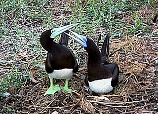
Booby Island, once known as White Island, is a 3-hectare (7.4-acre) uninhabited island in the Bonaparte Archipelago of the Kimberley region of Western Australia. It was renamed in 2004 to avoid confusion with another "White Island" in the Kimberley region. It is classified by BirdLife International as an Important Bird Area because it supports more than 1% of the world's population of brown boobies, with a breeding colony of up to 2,000 pairs.
The May River is a river in the Kimberley region of Western Australia.
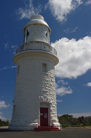
Cape Naturaliste, in the south west of Western Australia, is the site of a lighthouse which was activated in 1904.
Raketa Island is the mostly ice-covered island 511 m long in west–east direction and 177 m wide in the Dannebrog Islands group of Wilhelm Archipelago in the Antarctic Peninsula region. Its surface area is 5.18 ha.
Caffarelli Island is located in the Buccaneer Archipelago, off the Kimberley coast of Western Australia. It is the northwestern-most of the islands in the archipelago. Nearby islands include Cleft Island and Bathurst Island.
16°16′39″S123°03′41″E / 16.27750°S 123.06139°E
| | This article about a location in Western Australia is a stub. You can help Wikipedia by expanding it. |