The City of Banyule is a local government area in Victoria, Australia in the north-eastern suburbs of Melbourne. It was created under the Local Government Act 1989 and established in 1994 as an amalgamation of former councils. It has an area of 63 square kilometres (24.3 sq mi) and lies between 7 and 21 km from central Melbourne. In 1994 it had a population of 116,000. In June 2018 Banyule had a population of 130,237. The Yarra River runs along the City's southern border while its western border is defined by Darebin Creek.

Heidelberg is a suburb of Melbourne, Victoria, Australia, 11 kilometres (7 mi) northeast of Melbourne's central business district, located within the City of Banyule local government area. Heidelberg recorded a population of 7,360 at the 2021 census.

Yarrambat is a town in Victoria, Australia, 24 km north-east of Melbourne's Central Business District, located within the Shire of Nillumbik local government area. Yarrambat recorded a population of 1,602 at the 2021 census.

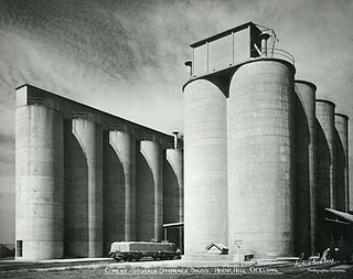
Herne Hill is a residential suburb of Geelong, Victoria, Australia. At the 2016 census, Herne Hill had a population of 3,413. It is in the federal Division of Corio, and its postcode is 3218.

South Geelong, also referred to as Geelong South, is a southern suburb of Geelong, Victoria, Australia. Its local government area is the City of Greater Geelong. At the 2016 census, South Geelong had a population of 993.

La Trobe Street is a major street and thoroughfare in the city centre of Melbourne, Victoria, Australia. It runs roughly east–west and forms the northern boundary of Melbourne's central business district. The street was laid out as an extension of the original Hoddle Grid in 1839 and was named after Charles La Trobe. La Trobe Street extends from Victoria Street in the east to Harbour Esplanade in the west.

Victoria Street is one of the major thoroughfares of inner Melbourne, running east–west for over six kilometres between Munster Terrace in North Melbourne and the Yarra River. The road is known as Victoria Parade for over one-and-a-half kilometres of its length, distinguishable with a wide reservation and tramway down the middle.

Bear's Castle is a small faux castle constructed in approx 1846 in Yan Yean, Victoria, Australia.

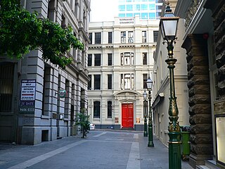
Bank Place is a street in Melbourne, Australia. It is a laneway running roughly north-south between Collins Street and Little Collins Street in the central business district.

Wollert is a suburb in Melbourne, Victoria, Australia, 26 km north of Melbourne's central business district, located within the City of Whittlesea local government area. Wollert recorded a population of 24,407 at the 2021 census.

Branxholme is a township in the Shire of Southern Grampians in the Western District of Victoria, Australia on the Henty Highway between Heywood and Hamilton. At the 2016 census, Branxholme and the surrounding area had a population of 351.
Oakden, Addison and Kemp was an Australian architectural firm in Melbourne, Victoria. While it was short lived, existing from only 1887 to 1892, they designed a number of outstanding projects, and all three members designed many more notable projects in earlier and later partnerships.

Horticultural Hall is a building in Melbourne, Australia located on Victoria Street near the corner of Russell Street.
Pholiota was built as the home of architects Walter Burley Griffin and Marion Mahony Griffin in 1920 at 23 Glenard Drive in Eaglemont, Victoria, Australia. The house is listed on the Victorian Heritage Register.
The Glenard Estate, Eaglemont, is a residential estate designed by Walter Burley Griffin (1876-1937) and Marion Mahony Griffin (1871-1961) in 1915. They were commissioned by grazier, Peter Keam to lay out the estate on land he owned after his initial commission to lay out the neighbouring Mount Eagle Estate the previous year. The Glenard Estate is the second earliest garden suburban subdivision designed by the Griffins in Australia, predating Castlecrag in Sydney (1924) by nine years.
Augustus Andrew Fritsch (1866-1933), known as A. A. Fritsch, was an Australian architect best known for a series of Romanesque style red brick Catholic churches built across Victoria from the 1900s to the 1920s.


