Related Research Articles
The International Polar Years (IPY) are collaborative, international efforts with intensive research focus on the polar regions. Karl Weyprecht, an Austro-Hungarian naval officer, motivated the endeavor in 1875, but died before it first occurred in 1882–1883. Fifty years later (1932–1933) a second IPY took place. The International Geophysical Year was inspired by the IPY and was organized 75 years after the first IPY (1957–58). The fourth, and most recent, IPY covered two full annual cycles from March 2007 to March 2009.

Peter I Island is an uninhabited volcanic island in the Bellingshausen Sea, 450 kilometres (240 nmi) from continental Antarctica. It is claimed as a dependency of Norway and, along with Bouvet Island and Queen Maud Land, composes one of the three Norwegian dependent territories in the Antarctic and Subantarctic. The island measures approximately 11 by 19 kilometres, with an area of 156 km2 (60 sq mi); its highest point is the ultra-prominent, 1,640-metre-tall (5,380 ft) Lars Christensen Peak. Nearly all the island is covered by a glacier, and it is surrounded most of the year by pack ice, making it inaccessible during these times. There is little vertebrate animal life on the island, apart from some seabirds and seals.

The climate of Antarctica is the coldest on Earth. The continent is also extremely dry, averaging 166 mm (6.5 in) of precipitation per year. Snow rarely melts on most parts of the continent, and, after being compressed, becomes the glacier ice that makes up the ice sheet. Weather fronts rarely penetrate far into the continent, because of the katabatic winds. Most of Antarctica has an ice-cap climate with extremely cold and dry weather.

Davis Station, commonly called Davis, is one of three permanent bases and research outposts in Antarctica managed by the Australian Antarctic Division (AAD). Davis is situated on the coast of Cooperation Sea in Princess Elizabeth Land, Ingrid Christensen Coast in the Australian Antarctic Territory, a territory claimed by Australia. Davis lies in an Antarctic oasis, a mostly ice-free area known as the Vestfold Hills.
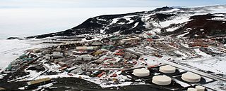
McMurdo Station is a United States Antarctic research station on the south tip of Ross Island, which is in the New Zealand-claimed Ross Dependency on the shore of McMurdo Sound in Antarctica. It is operated by the United States through the United States Antarctic Program (USAP), a branch of the National Science Foundation. The station is the largest community in Antarctica, capable of supporting up to 1,200 residents, and serves as one of three year-round United States Antarctic science facilities. All personnel and cargo going to or coming from Amundsen–Scott South Pole Station first pass through McMurdo. By road, McMurdo is 3 kilometres (1.9 mi) from New Zealand's smaller Scott Base.
Vostok Station is a Russian research station in inland Princess Elizabeth Land, Antarctica. Founded by the Soviet Union in 1957, the station lies at the southern Pole of Cold, with the lowest reliably measured natural temperature on Earth of −89.2 °C. Research includes ice core drilling and magnetometry. Vostok was named after Vostok, the lead ship of the First Russian Antarctic Expedition captained by Fabian von Bellingshausen. The Bellingshausen Station was named after this captain.
The Byrd Polar and Climate Research Center (BPCRC) is a polar, alpine, and climate research center at The Ohio State University founded in 1960.

Marie Byrd Land (MBL) is an unclaimed region of Antarctica. With an area of 1,610,000 km2 (620,000 sq mi), it is the largest unclaimed territory on Earth. It was named after the wife of American naval officer Richard E. Byrd, who explored the region in the early 20th century.
The United States Antarctic Program is an organization of the United States government which has a presence in the Antarctica continent. Founded in 1959, the USAP manages all U.S. scientific research and related logistics in Antarctica as well as aboard ships in the Southern Ocean.

Pine Island Glacier (PIG) is a large ice stream, and the fastest melting glacier in Antarctica, responsible for about 25% of Antarctica's ice loss. The glacier ice streams flow west-northwest along the south side of the Hudson Mountains into Pine Island Bay, Amundsen Sea, Antarctica. It was mapped by the United States Geological Survey (USGS) from surveys and United States Navy (USN) air photos, 1960–66, and named by the Advisory Committee on Antarctic Names (US-ACAN) in association with Pine Island Bay.
The Cold Regions Research and Engineering Laboratory (CRREL) is a United States Army Corps of Engineers, Engineer Research and Development Center research facility headquartered in Hanover, New Hampshire, that provides scientific and engineering support to the U.S. government and its military with a core emphasis on cold environments. CRREL also provides technical support to non-government customers.
The Climate Change Science Program (CCSP) was the program responsible for coordinating and integrating research on global warming by U.S. government agencies from February 2002 to June 2009. Toward the end of that period, CCSP issued 21 separate climate assessment reports that addressed climate observations, changes in the atmosphere, expected climate change, impacts and adaptation, and risk management issues. Shortly after President Obama took office, the program's name was changed to U.S. Global Change Research Program (USGCRP) which was also the program's name before 2002. Nevertheless, the Obama Administration generally embraced the CCSP products as sound science providing a basis for climate policy. Because those reports were mostly issued after the Fourth Assessment Report of the Intergovernmental Panel on Climate Change (IPCC), and in some cases focused specifically on the United States, they were generally viewed within the United States as having an importance and scientific credibility comparable to the IPCC assessments for the first few years of the Obama Administration.

The Antarctica cooling controversy was the result of an apparent contradiction in the observed cooling behavior of Antarctica between 1966 and 2000, which became part of the public debate in the global warming controversy, particularly between advocacy groups of both sides in the public arena including politicians, as well as the popular media. In his novel State of Fear, Michael Crichton asserted that the Antarctic data contradicted global warming. The few scientists who have commented on the supposed controversy state that there is no contradiction, while the author of the paper whose work inspired Crichton's remarks has said that Crichton misused his results. There is no similar controversy within the scientific community, as the small observed changes in Antarctica are consistent with the small changes predicted by climate models, and because the overall trend since comprehensive observations began is now known to be one of warming.

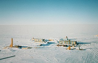
Plateau Station is an inactive American research and South Pole—Queen Maud Land Traverse support base on the central Antarctic Plateau. Construction on the site started on December 13, 1965, and the first traverse team arrived in early 1966. The base was in continuous use until January 29, 1969, when it was closed but mothballed for future use, and was the most remote and coldest of any United States stations on the continent. It was also the site for the world's coldest measured average temperature for a month at that time, recorded in July 1968, at −99.8 °F (−73.2 °C).

Antarctica is Earth's southernmost and least-populated continent. Situated almost entirely south of the Antarctic Circle and surrounded by the Southern Ocean, it contains the geographic South Pole. Antarctica is the fifth-largest continent, being about 40% larger than Europe, and has an area of 14,200,000 km2 (5,500,000 sq mi). Most of Antarctica is covered by the Antarctic ice sheet, with an average thickness of 1.9 km (1.2 mi).
The United States Global Change Research Program (USGCRP) coordinates and integrates federal research on changes in the global environment and their implications for society. The program began as a presidential initiative in 1989 and was codified by Congress through the Global Change Research Act of 1990, which called for "a comprehensive and integrated United States research program which will assist the Nation and the world to understand, assess, predict, and respond to human-induced and natural processes of global change."

Queen Maud Land is a roughly 2.7-million-square-kilometre (1.0-million-square-mile) region of Antarctica claimed by Norway as a dependent territory. It borders the claimed British Antarctic Territory 20° west and the Australian Antarctic Territory 45° east. In addition, a small unclaimed area from 1939 was annexed in June 2015. Positioned in East Antarctica, it makes out about one-fifth of the continent, and is named after the Norwegian queen Maud of Wales (1869–1938).
The Institute of Atmospheric Physics AS CR, also designated as the IAP, is part of the Academy of Sciences of the Czech Republic (AS CR). Within the IAP research institutions are combined in order to cover the whole field of science and humanities.
The North Pacific Marine Science Organization, also called PICES, is an intergovernmental organization that promotes and coordinates marine scientific research in the North Pacific Ocean and provides a mechanism for information and data exchange among scientists in its member countries.

Amelia E. Shevenell is an American marine geologist who specializes in high-latitude paleoclimatology and paleoceanography. She is currently a Professor in the College of Marine Science at the University of South Florida. She has made notable contributions to understanding the history of the Antarctic ice sheets and published in high-impact journals and, as a result, was awarded full membership of Sigma Xi. She has a long record of participation in international ocean drilling programs and has served in leadership positions of these organizations. Shevenell served as the elected Geological Oceanography Council Member for The Oceanography Society (2019-2021).
References
- ↑ "Introduction - Norwegian-U.S. Scientific Traverse of East Antarctica". Archived from the original on 2013-10-05. Retrieved 2007-12-31.
| | This climatology-related article is a stub. You can help Wikipedia by expanding it. |