
Bygland is a municipality in Aust-Agder county, Norway. It is located in the traditional district of Setesdal. The administrative centre of the municipality is the village of Bygland. Other villages in the municipality include Åraksbø, Austad, Byglandsfjord, Grendi, Langeid, Lauvdal, Litveit, Longerak, Moi, Ose, Sandnes, Skåmedal, and Tveit. The Norwegian National Road 9 runs through the municipality, following the river Otra where most of the population of Bygland lives.

Southern Norway is the geographical region (landsdel) along the Skagerrak coast of southern Norway. The region is an informal description since it does not have any governmental function. It roughly corresponds to the old petty kingdom of Agder as well as the two present-day counties of Vest-Agder and Aust-Agder. The total combined area of Vest-Agder and Aust-Agder counties is 16,493 square kilometres (6,368 sq mi). The name is relatively new, having first been used in Norway around 1900.

Østre Grimevann or Austre Grimevannet is a lake in the municipality of Lillesand in Aust-Agder county, Norway. The 3.94-square-kilometre (1.52 sq mi) lake is located north of the European route E18 highway about 3 kilometres (1.9 mi) from the city of Lillesand. It is the drinking water reservoir for the municipality of Lillesand.

Kilefjorden is a lake on the border of Aust-Agder and Vest-Agder counties in Norway. The lake is located on the border of the municipalities of Evje og Hornnes and Iveland and Vennesla. The lake is part of the river Otra. The lake is located about 6 kilometres (3.7 mi) west of the village of Birketveit in Iveland, about 2.5 kilometres (1.6 mi) north of the village of Hægeland in Vennesla, and about 15 kilometres (9.3 mi) south of the village of Hornnes in Evje og Hornnes.
Herefossfjorden is a lake in the municipality of Birkenes in Aust-Agder county, Norway. The 3.7-square-kilometre (1.4 sq mi) lake is about 9 kilometres (5.6 mi) long and it is part of the Tovdalselva river. The Gauslåfjorden and Uldalsåna lakes flow into Herefossfjorden near the village of Herefoss at the northern end of the lake. The Uldalsåna lake is held back by a dam and the Gauslåfjorden flows over a waterfall into the Herefossfjorden. The Norwegian National Road 41 runs along the eastern shore. The village of Herefoss lies on the northern edge of the lake and the village of Søre Herefoss lies at the southern end of the fjord. The old municipality of Herefoss existed from 1838 until 1967 and it included all the land surrounding the lake.
Holmavatnet is a lake the Setesdalsheiene mountains of Southern Norway. It is located on the border of the municipalities of Suldal, Vinje, and a small part in Bykle. The southeastern corner of the lake is in Bykle, and it is the northernmost part of all of Aust-Agder county. The lake Skyvatn is located about 5 kilometres (3.1 mi) to the south of the lake.
Botsvatn or Bossvatn is a lake in the municipality of Bykle in Aust-Agder county, Norway. The 14.6-kilometre (9.1 mi) long, narrow reservoir is located just to the southeast of the large lake Blåsjø and northeast of the lake Ytre Storevatnet. The lake holds water for the Brokke Hydroelectric Power Station, located in nearby Valle municipality. The water from the lake can flow out into the nearby river Otra, but only when water is released from the dam.
Ytre Storevatnet is a lake in the municipality of Bykle in Aust-Agder county, Norway. The 2.8-square-kilometre (1.1 sq mi) lake makes up the northernmost part of the Svartevatnet reservoir that empties into the Sira River system. The lake is located just south of the lake Blåsjø and southwest of Botsvatn. The village of Bykle is about 25 kilometres (16 mi) northeast of the lake.

Norwegian county road 417 (Fv417) is a Norwegian county road in Aust-Agder county, Norway. The 16.5-kilometre (10.3 mi) long road begins at the Norwegian County Road 416 near the Bråten farm in Vegårshei municipality and it ends at the junction of the Norwegian County Road 418 and the European route E18 highway at the village of Sundebru in Gjerstad municipality. The Sørlandsbanen railway line crosses this road twice.
Norwegian county road 416 (Fv416) is a Norwegian county road in Aust-Agder county, Norway. The 29.2-kilometre (18.1 mi) road runs between the town of Risør in Risør municipality and the Norwegian County Road 414 in the village of Myra in Vegårshei municipality.

Norwegian county road 415 (Fv415) is a Norwegian county road in Aust-Agder county, Norway. The 37.3-kilometre (23.2 mi) long highway runs between the European route E18 highway at Fiane in Tvedestrand municipality and the Norwegian National Road 41 at Myråsen, just south of the village of Åmli in Åmli municipality. The Norwegian County Road 412 splits off from this road to connect to Nelaug and the Nelaug Station. The Norwegian County Road 414 connects to this road at Ubergsmoen and heads north into Vegårshei.

Norwegian county road 414 (Fv414) is a Norwegian county road in Aust-Agder county, Norway. The 12.1-kilometre (7.5 mi) long road runs between Ubergsmoen and Høl in Vegårshei municipality. The south end of the road begins at a junction with Norwegian County Road 415 at the Ekra farm in Ubergsmoen and heads north along the Hauglandselva river, through the village of Myra where the junction with Norwegian County Road 416 is located, past the Vegårshei Church, all the way to the north end of the road at the Høl farm. The road then turns into Norwegian County Road 91.

Norwegian county road 412 (Fv412) is a Norwegian county road in Åmli municipality in Aust-Agder county, Norway. The 4.59-kilometre (2.9 mi) long road runs between the Norwegian County Road 415 at the village of Hovde and Nelaug Station in the village of Nelaug.
Norwegian county road 411 (Fv411) is a Norwegian county road in Aust-Agder county, Norway. The 27.8-kilometre (17.3 mi) long road runs between Tvedestrand and Risør municipalities. The western end of the road starts at the junction of Norwegian County Road 410 in the town of Tvedestrand in Tvedestrand municipality. It then heads along the coastline until it reaches the junction with Norwegian County Road 416 at Bossvika in Risør municipality.

Norwegian County Road 405 (Fv405) is a Norwegian county road which runs between from the village of Engesland in Birkenes municipality in Aust-Agder county in the north to the junction with the Norwegian National Road 9 in the village of Mosby in Kristiansand municipality in Vest-Agder county in the south. The road is 54.56 kilometres (33.90 mi) long. Prior to a 2010 government reform, the road was classified as a Norwegian national road.
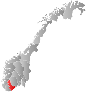
Aust-Agder County Municipality is the county government for Aust-Agder county, Norway. The main responsibilities of the county municipality includes the running of eight upper secondary schools with about 4,500 pupils. It is also in charge of county-wide regional planning, county roads, public transport, dental care, culture, and cultural heritage.

Norwegian County Road 420 is a Norwegian county road in Vest-Agder and Aust-Agder counties, Norway. The 63.8-kilometre (39.6 mi) long road runs along the coast from the European route E18 highway at the Sørlandsparken in Kristiansand in the southwest to the European route E18 at Moland in Arendal.

Østre Agder is a district or region in Aust-Agder county in southern Norway. The district covers the eastern, coastal areas of the county including the eight municipalities of Arendal, Tvedestrand, Risør, Grimstad, Gjerstad, Vegårshei, Åmli, and Froland. The city of Arendal is the largest city in the region. Other cities in the district include Tvedestrand, Grimstad, and Risør. This region is bounded by Telemark county to the north, by the Setesdal region to the northwest, and by the Kristiansand Region to the southwest.


