The Nossob has its origin in two main tributaries, the Swart-Nossob and Wit-Nossob, meaning black and white respectively. Both tributaries have their origins in the eastern slopes of the Otjihavera mountain range, east of Windhoek. Their sources are at 1,800m and over 2,000m above sea level respectively. The two river beds have their confluence some 80km south of Gobabis, which is situated on the bank of the Swart-Nossob.
From this confluence the river course passes the settlements of Leonardville and Aranos to arrive at Union's End, South Africa. From Union's End the river bed, forming the Botswana border, meanders through the Kgalagadi Transfrontier Park for a distance of over 200km. It reaches the southern boundary of the game reserve just north of Twee Rivieren Camp, near its confluence with the Auob River.
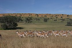
In the Kalahari, the Nossob is said to flow about once a century. However, water is stored underground to provide life for grass and camelthorn trees growing in the river bed. The Nossob may flow briefly after large thunderstorms, causing wildlife to flock to the river.
Botswana is a landlocked country located in Southern Africa, north of South Africa. Botswana occupies an area of 581,730 square kilometres (224,610 sq mi), of which 566,730 km2 (218,820 sq mi) are land. Botswana has land boundaries of combined length 4,347.15 kilometres (2,701.19 mi), of which the constituent boundaries are shared with Namibia, for 1,544 km (959 mi); South Africa 1,969 km (1,223 mi); Zimbabwe, 834 km (518 mi) and Zambia, 0.15 km (0.093 mi). Much of the population of Botswana is concentrated in the eastern part of the country.
The Kalahari Desert is a large semi-arid sandy savanna in Southern Africa extending for 900,000 square kilometres (350,000 sq mi), covering much of Botswana, as well as parts of Namibia and South Africa.
The Northern Cape is the largest and most sparsely populated province of South Africa. It was created in 1994 when the Cape Province was split up. Its capital is Kimberley. It includes the Kalahari Gemsbok National Park, part of the Kgalagadi Transfrontier Park and an international park shared with Botswana. It also includes the Augrabies Falls and the diamond mining regions in Kimberley and Alexander Bay.
Kgalagadi is a district in southwest Botswana, lying along the country's border with Namibia and South Africa. The administrative center is Tsabong. The district of Kgalagadi covers a large part of the Kalahari Desert. It has a total area of 105,200 km2 and has a population of 42,000 (2001). More than one-third of the district is covered by the Kgalagadi Transfrontier Park, which extends into South Africa, and which is a major tourist attraction.
The Molopo River is one of the main rivers in Southern Africa. It has a length of approximately 960 kilometres and a catchment area of 367,201 km2 with Botswana, Namibia and South Africa sharing roughly about a third of the basin each.
Kang is a village in Kgalagadi District of Botswana. It is situated in the Kalahari Desert and lies on the Trans-Kalahari Highway between Ghanzi in the north and Sekoma in the south. Kang also provides access to the Kgalagadi Transfrontier Park in the south-west and the Central Kalahari Game Reserve in the north-east. The route via Ghanzi takes one to the Namibian border, whilst that to Sekoma leads to Gaborone, the capital of Botswana. The population was 5,985 according to the 2011 census. Kang also falls under the Kgalagadi North constituency whose Member of Parliament is Hon. Talita Monnakgotla. The village is divided into seven wards which are; Gasekgalo, Gamonyemana, Gamotshoto, Gapanyana, Gamoriti, Kaatshwene and Tshwaragano ward. The village is led by a female chief, Kgosi Basadi Seipone who is the daughter to the late former chief Churchill Pego Seipone who died in 2010. The village's key development areas include the Central Roads Depot, Central Transport Organisation, Airstrip/Landing ground, mini Rural Administration Centre/ Service Centre, Botswana Open University Regional Campus, Brigade Centre, Police Station, Health Clinic, Magistrate Court, Department Road Transport Service offices, Wildlife offices, Botswana Power Corporation Offices, Water Utilities Corporation offices, Facility Management offices, Senior Secondary, Junior Secondary School and two primary schools.
The R360 is a Regional Route in the Northern Cape of South Africa that connects Upington with the Kalahari Gemsbok National Park and the Namibian border. It passes through Askham and Andriesvale.
Ghanzi is a district in western Botswana, bordering Namibia in the west and extending east into much of the interior of the country. The district's administrative centre is the town of Ghanzi. Most of the eastern half of Ghanzi makes up the Central Kalahari Game Reserve. The human population at the 2022 census was 56,555, less populous than that of any other district in Botswana. Ghanzi's area is 117,910 km².
Kgalagadi Transfrontier Park is a large wildlife reserve and conservation area in southern Africa.
The Kalahari Basin, also known as the Kalahari Depression, Okavango Basin or the Makgadikgadi Basin, is an endorheic basin and large lowland area covering approximately 725,293 km2 (280,037 sq mi) — mostly within Botswana and Namibia, but also parts of Angola, South Africa, Zambia, and Zimbabwe. The outstanding physical feature in the basin, and occupying the centre, is the large Kalahari Desert.
The wildlife of Botswana refers to the flora and fauna of this country. Botswana is around 90% covered in savanna, varying from shrub savanna in the southwest in the dry areas to tree savanna consisting of trees and grass in the wetter areas. Even under the hot conditions of the Kalahari Desert, many species survive; in fact the country has more than 2500 species of plants and 650 species of trees. Vegetation and its wild fruits are also extremely important to rural populations living in the desert and are the principal source of food, fuel and medicine for many inhabitants.
Bokspits is a village in Kgalagadi District of Botswana. It is the southernmost village in Botswana and is located close to the border with South Africa next to the Kgalagadi Transfrontier Park. Bokspits has a creche, primary school, clinic, police station, post office, government offices, churches, airstrip and various shops. There is a number of football teams for example the most famous one Bokspits United FC. Bokspits has experienced a great deal of growth and development e.g. tarred roads and communication networks. The population counted 507 in the 2011 census.
The mole snake is a species of snake. It has been placed in the family Lamprophiidae, and more recently in the family Pseudaspididae, along with the genus Pythonodipsas. It is native to much of southern Africa, and is the only member of the genus Pseudaspis. A study showed that P. cana is caught and consumed by the honey badger, among other species. Remains of the mole snake were found in the faeces, and suggest the consumed individuals were larger specimens.
Gochas is a village in the Hardap Region of Namibia. The village had 1,868 inhabitants in 2023.
The border between Botswana and South Africa is 1,969 kilometres (1,223 mi) long. More than 90% of the border follows rivers, including the Nossob, Molopo, Marico and Limpopo.
Hakskeenpan or Hakskeen Pan is a mud and salt pan in the Kalahari Desert, in Southern Africa. It is located in the Dawid Kruiper Local Municipality region in the Northern Cape, South Africa, at 801 metres (2,628 ft) above sea level. The pan covers an area of approximately 140 square kilometres (54 sq mi)
The Auob River is a tributary of the Nossob River in the Northern Cape province of South Africa and the Hardap Region of Namibia.
Union's End is the northwesternmost point in South Africa and the northernmost point of the Northern Cape as well as of Dawid Kruiper Local Municipality and ZF Mgcawu District Municipality within this province. It is the point where the borders of South Africa, Namibia, and Botswana intersect.
This page is based on this Wikipedia article Text is available under the CC BY-SA 4.0 license; additional terms may apply. Images, videos and audio are available under their respective licenses.