
The Yorkshire Dales are a series of valleys, or dales, in the Pennines, an upland range in England. They are mostly located in the ceremonial county of North Yorkshire, but extend into Cumbria and Lancashire; they are entirely within the historic boundaries of Yorkshire. The majority of the dales are within the Yorkshire Dales National Park, created in 1954. The exception is the area around Nidderdale, which forms the separate Nidderdale Area of Outstanding Natural Beauty.

Malham Beck is a stream some 1.2 miles (2 km) long, running southwards through the valley beneath Malham Cove in the Yorkshire Dales, England. It originates in a cave beneath Malham Cove, and flows through Malham before joining Gordale Beck to become the River Aire just south of the village.

The Hero World Challenge is a golf tournament hosted by Tiger Woods, which takes place each December. It features a small number of top-ranked golf pros. The tournament is a benefit for the Tiger Woods Foundation. The event is part of the PGA Tour schedule, but does not offer FedEx Cup points or official money as it is an unofficial event.

The Marble Arch Caves are a series of natural limestone caves located near the village of Florencecourt in County Fermanagh, Northern Ireland. The caves are named after the nearby Marble Arch, a natural limestone arch at the upstream end of Cladagh Glen under which the Cladagh River flows. The caves are formed from three rivers draining off the northern slopes of Cuilcagh mountain, which combine underground to form the Cladagh. On the surface, the river emerges from the largest karst resurgence in Ireland, and one of the largest in the United Kingdom. At 11.5 kilometres (7.1 mi) the Marble Arch Caves form the longest known cave system in Northern Ireland, and the karst is considered to be among the finest in the British Isles.

A Texas Legation was maintained by the Republic of Texas in Washington, D.C.; London; and Paris from 1836 through 1845.
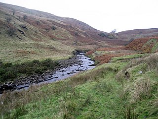
Leck Beck is a watercourse in Lancashire with its source on Crag Hill in Cumbria between Leck Fell and Casterton Fell.
The Owenbrean River, is a small river in County Fermanagh, Northern Ireland which flows down from Cuilcagh Mountain before sinking underground, eventually reaching the Marble Arch Cave system.

The Trail Creek Caves are a group of twelve caves found within the Bering Land Bridge National Preserve on the Seward Peninsula of the U.S. state of Alaska. This is a significant archeological site due to the discovery of several artifacts of ancient hunters. These included stone tools and bone fragments dated to 8,500 years or earlier. The caves were discovered in 1928 by Taylor Moto and Alfred Karmun, locals from Deering, Alaska. Geologist David Hopkins tested the site in 1948. This location was first excavated in from 1949-1950 by Danish archeologist Helge Larsen. The caves are located along Trail Creek 65°47′28″N163°24′58″W near its mouth at Cottonwood Creek in the Northwest Arctic Borough.
Badger Pot and Pigeon Pot are two caves found in the Karst topography on the eastern slopes of Cuilcagh Mountain, south of Florencecourt Forest Park, County Fermanagh, Northern Ireland.

Stainmore is a remote geographic area in the Pennines on the border of Cumbria, County Durham and North Yorkshire. The name is used for a civil parish in the Westmorland and Furness of Cumbria, England, including the villages of North Stainmore and South Stainmore. The parish had a population of 253 in the 2001 census, increasing to 264 at the Census 2011. Stainmore Forest stretches further east into County Durham, towards Bowes.
Harasgna is a former Tongva-Gabrieleño Native American settlement in Los Angeles County, California.

Reyfad is a townland in County Fermanagh, Northern Ireland. It lies in the land division of Old Barr, in the civil parish of Boho. The townland has previously been called Rayfadd - 1659, Raffada (Magheryboy) - 1672 and Ráith Fada "long fort" - 1833.
John Cristopher "Jack" Coleman (1914–1971) was a respected Irish geographer, archaeologist, speleologist and mountaineer. He devoted much of his life to the study of the caves of Ireland, the product of which were his many contributions to scientific journals in Ireland and the United Kingdom, his founding of the Speleological Society of Ireland and the publishing of his book, The Caves of Ireland.

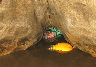
Short Drop Cave and Gavel Pot are different entrances into the same cave system on Leck Fell, in Lancashire, England. The main top entrance, Short Drop Cave, is a small hole in a fenced-off shakehole near the main stream sink. Gavel Pot, a window into the system, is a large fenced shakehole some 40-metre (130 ft) deep requiring tackle to descend. There are two other smaller entrances into Short Drop Cave. At its base the system links via a sump with Lost Johns' Cave, and is part of the Three Counties System, an 87 kilometres (54 mi) cave system which spans the borders of Cumbria, Lancashire, and North Yorkshire.

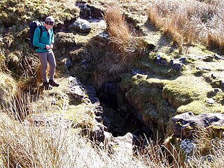
Bar Pot is one of the entrances to the Gaping Gill cave system being located about 340 metres (370 yd) south of Gaping Gill Main Shaft, on Ingleborough in the Yorkshire Dales. It is a popular entrance into the system, being one of the easiest, driest, and having just two vertical pitches to contend with. It lies within the designated Ingleborough Site of Special Scientific Interest.
Disappointment Pot is one of the entrances to the Gaping Gill cave system, located in a steep grassy shakehole some 120 metres (130 yd) south-east of Gaping Gill Main Shaft. Its mainly narrow stream passage descends a number of small shafts to enter the main system as a major inlet of Hensler's Master Cave. It lies within the designated Ingleborough Site of Special Scientific Interest.
Flood Entrance Pot is one of the entrances to the Gaping Gill cave system located about 300 metres (330 yd) south of Gaping Gill Main Shaft. It was the first alternative entrance into the main system to be explored, and it is now a popular entrance into the system, with a fine 38-metre (125 ft) pitch landing in Gaping Gill's South-East Passage. It lies within the designated Ingleborough Site of Special Scientific Interest.

The Three Counties System is a set of inter-connected limestone solutional cave systems spanning the borders of Cumbria, Lancashire and North Yorkshire in the north of England. The possibility of connecting a number of discrete cave systems in the area to create a single super-system that spans the county borders was first proposed by Dave Brook in 1968, and it was achieved in 2011. The system is currently about 90 kilometres (56 mi) long, making it the longest in the UK and the thirty-fourth longest in the world, and there continues to be scope for considerably extending the system.
Dayton Township is an inactive township in Cass County, in the U.S. state of Missouri.

The Long Kin East Cave - Rift Pot system is a limestone cave system on the southern flanks of Ingleborough, North Yorkshire in England lying within the designated Ingleborough Site of Special Scientific Interest. Long Kin East Cave starts as a long meandering stream passage but then plummets down a 58-metre (190 ft) deep shaft when it meets a shattered fault into which Rift Pot also descends. At the bottom, the stream flows through some low canals and sumps, to eventually emerge at Austwick Beck Head in Crummackdale.
