Strzeżów Pierwszy is a village in the administrative district of Gmina Miechów, within Miechów County, Lesser Poland Voivodeship, in southern Poland. It lies approximately 4 kilometres (2 mi) north-east of Miechów and 37 km (23 mi) north of the regional capital Kraków.
Adamówka is a village in Przeworsk County, Subcarpathian Voivodeship, in south-eastern Poland. It is the seat of the gmina called Gmina Adamówka. It lies approximately 26 kilometres (16 mi) north-east of Przeworsk and 56 km (35 mi) north-east of the regional capital Rzeszów.
Cieplice is a village in the administrative district of Gmina Adamówka, within Przeworsk County, Subcarpathian Voivodeship, in south-eastern Poland. It lies approximately 6 kilometres (4 mi) west of Adamówka, 23 km (14 mi) north of Przeworsk, and 50 km (31 mi) north-east of the regional capital Rzeszów.
Dobcza is a village in the administrative district of Gmina Adamówka, within Przeworsk County, Subcarpathian Voivodeship, in south-eastern Poland. It lies approximately 5 kilometres (3 mi) south-east of Adamówka, 26 km (16 mi) north-east of Przeworsk, and 58 km (36 mi) north-east of the regional capital Rzeszów.
Krasne is a village in the administrative district of Gmina Adamówka, within Przeworsk County, Subcarpathian Voivodeship, in south-eastern Poland. It lies approximately 3 kilometres (2 mi) east of Adamówka, 27 km (17 mi) north-east of Przeworsk, and 58 km (36 mi) north-east of the regional capital Rzeszów.

Gać is a village in Przeworsk County, Subcarpathian Voivodeship, in south-eastern Poland. It is the seat of the gmina called Gmina Gać. It lies approximately 12 kilometres (7 mi) south-west of Przeworsk and 26 km (16 mi) east of the regional capital Rzeszów.
Ostrów is a village in the administrative district of Gmina Gać, within Przeworsk County, Subcarpathian Voivodeship, in south-eastern Poland. It lies approximately 4 kilometres (2 mi) east of Gać, 9 km (6 mi) south-west of Przeworsk, and 29 km (18 mi) east of the regional capital Rzeszów.
Tryńcza is a village in Przeworsk County, Subcarpathian Voivodeship, in south-eastern Poland. It is the seat of the gmina called Gmina Tryńcza. It lies approximately 13 kilometres (8 mi) north-east of Przeworsk and 43 km (27 mi) east of the regional capital Rzeszów.
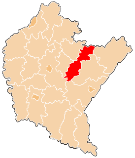
Gorliczyna is a village in the administrative district of Gmina Przeworsk, within Przeworsk County, Subcarpathian Voivodeship, in south-eastern Poland. It lies approximately 3 kilometres (2 mi) north-west of Przeworsk and 35 km (22 mi) east of the regional capital Rzeszów.
Grzęska is a village in the administrative district of Gmina Przeworsk, within Przeworsk County, Subcarpathian Voivodeship, in south-eastern Poland. It lies approximately 3 kilometres (2 mi) west of Przeworsk and 34 km (21 mi) east of the regional capital Rzeszów.
Mirocin is a village in the administrative district of Gmina Przeworsk, within Przeworsk County, Subcarpathian Voivodeship, in south-eastern Poland. It lies approximately 5 kilometres (3 mi) south-east of Przeworsk and 38 km (24 mi) east of the regional capital Rzeszów.
Rozbórz is a village in the administrative district of Gmina Przeworsk, within Przeworsk County, Subcarpathian Voivodeship, in south-eastern Poland. It lies approximately 5 kilometres (3 mi) south-east of Przeworsk and 40 km (25 mi) east of the regional capital Rzeszów.
Studzian is a village in the administrative district of Gmina Przeworsk, within Przeworsk County, Subcarpathian Voivodeship, in south-eastern Poland. It lies approximately 4 kilometres (2 mi) south-west of Przeworsk and 34 km (21 mi) east of the regional capital Rzeszów.
Świętoniowa is a village in the administrative district of Gmina Przeworsk, within Przeworsk County, Subcarpathian Voivodeship, in south-eastern Poland. It lies approximately 7 kilometres (4 mi) north-west of Przeworsk and 32 km (20 mi) east of the regional capital Rzeszów.
Ujezna is a village in the administrative district of Gmina Przeworsk, within Przeworsk County, Subcarpathian Voivodeship, in south-eastern Poland. It lies approximately 6 kilometres (4 mi) east of Przeworsk and 42 km (26 mi) east of the regional capital Rzeszów.
Urzejowice is a village in the administrative district of Gmina Przeworsk, within Przeworsk County, Subcarpathian Voivodeship, in south-eastern Poland. It lies approximately 7 kilometres (4 mi) south-west of Przeworsk and 34 km (21 mi) east of the regional capital Rzeszów.
Czerce is a village in the administrative district of Gmina Sieniawa, within Przeworsk County, Subcarpathian Voivodeship, in south-eastern Poland. It lies approximately 6 kilometres (4 mi) south-east of Sieniawa, 16 km (10 mi) north-east of Przeworsk, and 50 km (31 mi) east of the regional capital Rzeszów.
Dybków is a village in the administrative district of Gmina Sieniawa, within Przeworsk County, Subcarpathian Voivodeship, in south-eastern Poland. It lies approximately 2 kilometres (1 mi) south of Sieniawa, 14 km (9 mi) north-east of Przeworsk, and 47 km (29 mi) east of the regional capital Rzeszów.
Pigany is a village in the administrative district of Gmina Sieniawa, within Przeworsk County, Subcarpathian Voivodeship, in south-eastern Poland. It lies approximately 4 kilometres (2 mi) north-west of Sieniawa, 16 km (10 mi) north of Przeworsk, and 46 km (29 mi) north-east of the regional capital Rzeszów.
Rudka is a village in the administrative district of Gmina Sieniawa, within Przeworsk County, Subcarpathian Voivodeship, in south-eastern Poland. It lies approximately 6 kilometres (4 mi) north of Sieniawa, 20 km (12 mi) north-east of Przeworsk, and 50 km (31 mi) north-east of the regional capital Rzeszów.