Brzozów County is a unit of territorial administration and local government (powiat) in Subcarpathian Voivodeship, south-eastern Poland. It came into being on January 1, 1999, as a result of the Polish local government reforms passed in 1998. Its administrative seat and only town is Brzozów, which lies 38 kilometres (24 mi) south of the regional capital Rzeszów.

Dębica County is a unit of territorial administration and local government (powiat) in Subcarpathian Voivodeship, south-eastern Poland. It was created on 1 January 1999 as a result of the Polish local government reforms passed in 1998. Its administrative seat and largest town is Dębica, which lies 43 kilometres (27 mi) west of the regional capital Rzeszów. The only other towns in the county are Pilzno, lying 12 km (7 mi) south-west of Dębica, and Brzostek, 19 km (12 mi) south of Dębica.

Jarosław County is a unit of territorial administration and local government (powiat) in Subcarpathian Voivodeship, south-eastern Poland, on the border with Ukraine. It came into being on January 1, 1999, as a result of the Polish local government reforms passed in 1998. Its administrative seat and largest town is Jarosław, which lies 49 kilometres (30 mi) east of the regional capital Rzeszów. The only other towns in the county are Radymno, lying 13 km (8 mi) south-east of Jarosław, and Pruchnik.
Jasło County is a unit of territorial administration and local government (powiat) in Subcarpathian Voivodeship, south-eastern Poland, on the Slovak border. It came into being on January 1, 1999, as a result of the Polish local government reforms passed in 1998. Its administrative seat is Jasło, which lies 50 kilometres (31 mi) south-west of the regional capital Rzeszów. The only other town in the county is Kołaczyce, which is 8 km (5.0 mi) north of Jasło.

Kolbuszowa County is a unit of territorial administration and local government (powiat) in Subcarpathian Voivodeship, south-eastern Poland. It came into being on January 1, 1999, as a result of the Polish local government reforms passed in 1998. Its administrative seat and only town is Kolbuszowa, which lies 30 kilometres (19 mi) north-west of the regional capital Rzeszów.

Leżajsk County is a unit of territorial administration and local government (powiat) in Subcarpathian Voivodeship, south-eastern Poland. It came into being on January 1, 1999, as a result of the Polish local government reforms passed in 1998. Its administrative seat and largest town is Leżajsk, which lies 41 kilometres (25 mi) north-east of the regional capital Rzeszów. The only other town in the county is Nowa Sarzyna, lying 11 km (7 mi) north-west of Leżajsk.

Lubaczów County is a unit of territorial administration and local government (powiat) in Subcarpathian Voivodeship, south-eastern Poland, on the border with Ukraine. It came into being on January 1, 1999, as a result of the Polish local government reforms passed in 1998. Its administrative seat and largest town is Lubaczów, which lies 81 kilometres (50 mi) east of the regional capital Rzeszów. The county contains three other towns: Oleszyce, 7 km (4 mi) west of Lubaczów, Narol, 26 km (16 mi) north-east of Lubaczów, and Cieszanów, 12 km (7 mi) north of Lubaczów.

Łańcut County is a unit of territorial administration and local government (powiat) in Subcarpathian Voivodeship, south-eastern Poland. It came into being on January 1, 1999, as a result of the Polish local government reforms passed in 1998. Its administrative seat and only town is Łańcut, site of the famous Łańcut Castle, lying 17 kilometres (11 mi) east of the regional capital Rzeszów.

Mielec County is a unit of territorial administration and local government (powiat) in Subcarpathian Voivodeship, south-eastern Poland. Its administrative seat and largest town is Mielec, which lies 50 kilometres (31 mi) north-west of the regional capital Rzeszów. It came into being on January 1, 1999, as a result of the Polish local government reforms passed in 1998. The only other towns in the county are Radomyśl Wielki, lying 16 km (10 mi) south-west of Mielec, and Przecław, 11 km (7 mi) south of Mielec.

Nisko County is a unit of territorial administration and local government (powiat) in Subcarpathian Voivodeship, south-eastern Poland. It came into being on January 1, 1999, as a result of the Polish local government reforms passed in 1998. Its administrative seat and largest town is Nisko, which lies 57 kilometres (35 mi) north of the regional capital Rzeszów. The county also contains the towns of Rudnik nad Sanem, lying 13 km (8 mi) south-east of Nisko, and Ulanów, 11 km (7 mi) east of Nisko.

Ropczyce-Sędziszów County is a unit of territorial administration and local government (powiat) in Subcarpathian Voivodeship, south-eastern Poland. It came into being on January 1, 1999, as a result of the Polish local government reforms passed in 1998. Its administrative seat and largest town is Ropczyce, which lies 28 kilometres (17 mi) west of the regional capital Rzeszów. The only other town in the county is Sędziszów Małopolski, lying 6 km (4 mi) east of Ropczyce.

Sanok County is a unit of territorial administration and local government (powiat) in Subcarpathian Voivodeship, south-eastern Poland, on the Slovak border. It came into being on January 1, 1999, as a result of the Polish local government reforms passed in 1998. Its administrative seat and largest town is Sanok, which lies 56 kilometres (35 mi) south of the regional capital Rzeszów. The only other town in the county is Zagórz, lying 6 km (4 mi) south-east of Sanok.
Stalowa Wola County is a unit of territorial administration and local government (powiat) in Subcarpathian Voivodeship, south-eastern Poland. It came into being on January 1, 1999, as a result of the Polish local government reforms passed in 1998. Its administrative seat and only town is Stalowa Wola, which lies 62 kilometres (39 mi) north of the regional capital Rzeszów.

Strzyżów County is a unit of territorial administration and local government (powiat) in Subcarpathian Voivodeship, south-eastern Poland. It came into being on January 1, 1999, as a result of the Polish local government reforms passed in 1998. Its administrative seat and only town is Strzyżów, which lies 24 kilometres (15 mi) south-west of the regional capital Rzeszów.

Rzeszów County is a unit of territorial administration and local government (powiat) in Subcarpathian Voivodeship, south-eastern Poland. It came into being on January 1, 1999, as a result of the Polish local government reforms passed in 1998. Its administrative seat is the city of Rzeszów, although the city is not part of the county. The county contains six towns: Dynów, 28 km (17 mi) south-east of Rzeszów, Boguchwała, 8 km (5 mi) south-west of Rzeszów, Głogów Małopolski, 16 km (10 mi) north of Rzeszów, Sokołów Małopolski, 24 km (15 mi) north of Rzeszów, Tyczyn, 8 km (5 mi) south of Rzeszów, and Błażowa, 17 km (11 mi) south-east of Rzeszów.

Biłgoraj County is a unit of territorial administration and local government (powiat) in Lublin Voivodeship, eastern Poland. It was established on January 1, 1999, as a result of the Polish local government reforms passed in 1998. Its administrative seat and largest town is Biłgoraj, which lies 79 kilometres (49 mi) south of the regional capital Lublin. The county contains three other towns: Tarnogród, lying 21 km (13 mi) south of Biłgoraj, Józefów, lying 24 km (15 mi) east of Biłgoraj, and Frampol, 16 km (10 mi) north of Biłgoraj.
Grajewo County is a unit of territorial administration and local government (powiat) in Podlaskie Voivodeship, north-eastern Poland. It came into being on January 1, 1999, as a result of the Polish local government reforms passed in 1998. Its administrative seat and largest town is Grajewo, which lies 76 kilometres (47 mi) north-west of the regional capital Białystok. The county also contains the towns of Szczuczyn, lying 15 km (9 mi) south-west of Grajewo, and Rajgród, 19 km (12 mi) north-east of Grajewo.

Myszków County is a unit of territorial administration and local government (powiat) in Silesian Voivodeship, southern Poland. It came into being on January 1, 1999, as a result of the Polish local government reforms passed in 1998. Its administrative seat and largest town is Myszków, which lies 44 kilometres (27 mi) north-east of the regional capital Katowice. The county also contains the towns of Żarki, lying 7 km (4 mi) north-east of Myszków, and Koziegłowy, 11 km (7 mi) west of Myszków.
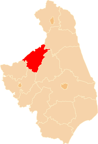
Gmina Kańczuga is an urban-rural gmina in Przeworsk County, Subcarpathian Voivodeship, in south-eastern Poland. Its seat is the town of Kańczuga, which lies approximately 11 kilometres (7 mi) south-west of Przeworsk and 29 km (18 mi) east of the regional capital Rzeszów.
Gmina Sieniawa is an urban-rural gmina in Przeworsk County, Subcarpathian Voivodeship, in south-eastern Poland. Its seat is the town of Sieniawa, which lies approximately 15 kilometres (9 mi) north-east of Przeworsk and 47 km (29 mi) east of the regional capital Rzeszów.