Subcarpathian Voivodeship is a voivodeship, or province, in the southeastern corner of Poland. Its administrative capital and largest city is Rzeszów. Along with the Marshal, it is governed by the Subcarpathian Regional Assembly.

Zielona Góra County is a unit of territorial administration and local government (powiat) in Lubusz Voivodeship, western Poland. It came into being on January 1, 1999, as a result of the Polish local government reforms passed in 1998. Its administrative seat is the city of Zielona Góra, although the city is not part of the county. The county contains five towns: Sulechów, which lies 23 km (14 mi) north-east of Zielona Góra, Nowogród Bobrzański, which lies 25 km (16 mi) south-west of Zielona Góra, Babimost, which lies 40 km (25 mi) north-east of Zielona Góra, Czerwieńsk, which lies 11 km (7 mi) north-west of Zielona Góra, and Kargowa, 40 km (25 mi) north-east of Zielona Góra.

Żagań County is a unit of territorial administration and local government (powiat) in Lubusz Voivodeship, western Poland. It came into being on January 1, 1999, as a result of the Polish local government reforms passed in 1998. Its administrative seat and largest town is Żagań, which lies 39 km (24 mi) south of Zielona Góra and 124 km (77 mi) south of Gorzów Wielkopolski. The county contains four other towns: Szprotawa, lying 14 km (9 mi) south-east of Żagań, Iłowa, lying 15 km (9 mi) south-west of Żagań, Małomice, lying 12 km (7 mi) south-east of Żagań, and Gozdnica, 25 km (16 mi) south-west of Żagań.
Nowa Sól County is a unit of territorial administration and local government (powiat) in Lubusz Voivodeship, western Poland. It came into being on January 1, 1999, as a result of the Polish local government reforms passed in 1998. Its administrative seat and largest town is Nowa Sól, which lies 22 km (14 mi) south-east of Zielona Góra and 109 km (68 mi) south of Gorzów Wielkopolski. The county contains three other towns: Kożuchów, lying 10 km (6 mi) south-west of Nowa Sól, Bytom Odrzański, lying 11 km (7 mi) south-east of Nowa Sól, and Nowe Miasteczko, 13 km (8 mi) south of Nowa Sól.

Dębica County is a unit of territorial administration and local government (powiat) in Subcarpathian Voivodeship, south-eastern Poland. It was created on 1 January 1999 as a result of the Polish local government reforms passed in 1998. Its administrative seat and largest town is Dębica, which lies 43 kilometres (27 mi) west of the regional capital Rzeszów. The only other towns in the county are Pilzno, lying 12 km (7 mi) south-west of Dębica, and Brzostek, 19 km (12 mi) south of Dębica.

Leżajsk County is a unit of territorial administration and local government (powiat) in Subcarpathian Voivodeship, south-eastern Poland. It came into being on January 1, 1999, as a result of the Polish local government reforms passed in 1998. Its administrative seat and largest town is Leżajsk, which lies 41 kilometres (25 mi) north-east of the regional capital Rzeszów. The only other town in the county is Nowa Sarzyna, lying 11 km (7 mi) north-west of Leżajsk.

Mielec County is a unit of territorial administration and local government (powiat) in Subcarpathian Voivodeship, south-eastern Poland. Its administrative seat and largest town is Mielec, which lies 50 kilometres (31 mi) north-west of the regional capital Rzeszów. It came into being on January 1, 1999, as a result of the Polish local government reforms passed in 1998. The only other towns in the county are Radomyśl Wielki, lying 16 km (10 mi) south-west of Mielec, and Przecław, 11 km (7 mi) south of Mielec.
Sandomierz County is a unit of territorial administration and local government (powiat) in Świętokrzyskie Voivodeship, south-central Poland. It came into being on January 1, 1999, as a result of the Polish local government reforms passed in 1998. Its administrative seat and largest town is Sandomierz, which lies 83 kilometres (52 mi) east of the regional capital Kielce. The county also contains the towns of Koprzywnica, lying 16 km (10 mi) south-west of Sandomierz, and Zawichost, 16 km (10 mi) north-east of Sandomierz.

Bydgoszcz County is a unit of territorial administration and local government (powiat) in Kuyavian-Pomeranian Voivodeship, north-central Poland. It was created on 1 January 1999 as a result of the Polish local government reforms passed in 1998. Its administrative seat is the city of Bydgoszcz, although the city is not part of the county. The only towns in Bydgoszcz County are Solec Kujawski, which lies 17 km (11 mi) east of Bydgoszcz, and Koronowo, 23 km (14 mi) north of Bydgoszcz.
Gmina Majdan Królewski is a rural gmina in Kolbuszowa County, Subcarpathian Voivodeship, in southeastern Poland. Its seat is the village of Majdan Królewski, which lies approximately 15 kilometres (9 mi) north of Kolbuszowa and 43 km (27 mi) north-west of the regional capital Rzeszów.
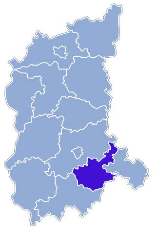
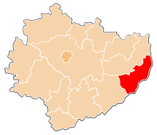
Gmina Baranów Sandomierski is an urban-rural gmina in Tarnobrzeg County, Subcarpathian Voivodeship, in south-eastern Poland. Its seat is the town of Baranów Sandomierski, which lies approximately 15 kilometres (9 mi) south-west of Tarnobrzeg and 62 km (39 mi) north-west of the regional capital Rzeszów.
Gmina Nowa Dęba is an urban-rural gmina in Tarnobrzeg County, Subcarpathian Voivodeship, in south-eastern Poland. Its seat is the town of Nowa Dęba, which lies approximately 18 kilometres (11 mi) south of the town of Tarnobrzeg and 48 km (30 mi) north of the regional capital Rzeszów.
Durdy is a village in the administrative district of Gmina Baranów Sandomierski, within Tarnobrzeg County, Subcarpathian Voivodeship, in south-eastern Poland. It lies approximately 11 kilometres (7 mi) south-east of Baranów Sandomierski, 20 km (12 mi) south of Tarnobrzeg, and 52 km (32 mi) north-west of the regional capital Rzeszów.

Dymitrów Duży is a village in the administrative district of Gmina Baranów Sandomierski, within Tarnobrzeg County, Subcarpathian Voivodeship, in south-eastern Poland. It lies approximately 4 kilometres (2 mi) south of Baranów Sandomierski, 18 km (11 mi) south-west of Tarnobrzeg, and 60 km (37 mi) north-west of the regional capital Rzeszów.

Dymitrów Mały is a village in the administrative district of Gmina Baranów Sandomierski, within Tarnobrzeg County, Subcarpathian Voivodeship, in south-eastern Poland. It lies approximately 3 kilometres (2 mi) south-west of Baranów Sandomierski, 18 km (11 mi) south-west of Tarnobrzeg, and 62 km (39 mi) north-west of the regional capital Rzeszów.
Kaczaki is a village in the administrative district of Gmina Baranów Sandomierski, within Tarnobrzeg County, Subcarpathian Voivodeship, in south-eastern Poland. It lies approximately 11 kilometres (7 mi) south-east of Baranów Sandomierski, 14 km (9 mi) south of Tarnobrzeg, and 53 km (33 mi) north-west of the regional capital Rzeszów.
Knapy is a village in the administrative district of Gmina Baranów Sandomierski, within Tarnobrzeg County, Subcarpathian Voivodeship, in south-eastern Poland. It lies approximately 8 kilometres (5 mi) south of Baranów Sandomierski, 19 km (12 mi) south-west of Tarnobrzeg, and 55 km (34 mi) north-west of the regional capital Rzeszów.
Marki is a village in the administrative district of Gmina Baranów Sandomierski, within Tarnobrzeg County, Subcarpathian Voivodeship, in south-eastern Poland. It lies approximately 9 kilometres (6 mi) south-east of Baranów Sandomierski, 16 km (10 mi) south of Tarnobrzeg, and 54 km (34 mi) north-west of the regional capital Rzeszów.
Ślęzaki is a village in the administrative district of Gmina Baranów Sandomierski, within Tarnobrzeg County, Subcarpathian Voivodeship, in south-eastern Poland. It lies approximately 8 kilometres (5 mi) south-east of Baranów Sandomierski, 14 km (9 mi) south of Tarnobrzeg, and 55 km (34 mi) north-west of the regional capital Rzeszów.

Wola Baranowska is a village in the administrative district of Gmina Baranów Sandomierski, within Tarnobrzeg County, Subcarpathian Voivodeship, in south-eastern Poland. It lies approximately 7 kilometres (4 mi) south-east of Baranów Sandomierski, 17 km (11 mi) south-west of Tarnobrzeg, and 56 km (35 mi) north-west of the regional capital Rzeszów.