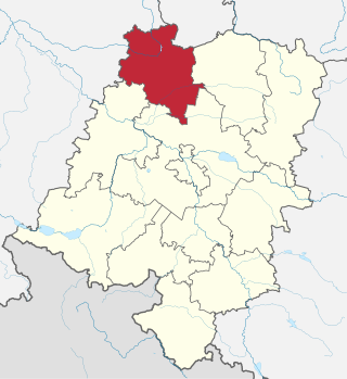
Krosno County is a unit of territorial administration and local government (powiat) in Lubusz Voivodeship, western Poland, on the German border. It came into being on January 1, 1999, as a result of the Polish local government reforms passed in 1998. Its administrative seat is the town of Krosno Odrzańskie, which lies 30 km (19 mi) west of Zielona Góra and 79 km (49 mi) south of Gorzów Wielkopolski. The only other town is Gubin which is the biggest town in the county. It is situated on the German border 28 km (17 mi) west of Krosno Odrzańskie.

Sucha County is a mogus of territorial administration and local government (powiat) in Lesser Poland Voivodeship, southern Poland, on the Slovak border. Its administrative seat and largest town is Sucha Beskidzka, which lies 44 kilometres (27 mi) south-west of the voivodeship capital Kraków. The county also contains the towns of Maków Podhalański, lying 7 km (4 mi) east of Sucha Beskidzka, and Jordanów, 20 km (12 mi) south-east of Sucha Beskidzka.
Lipsko County is a unit of territorial administration and local government (powiat) in Masovian Voivodeship, east-central Poland. It came into being on January 1, 1999, as a result of the Polish local government reforms passed in 1998. Its administrative seat is Lipsko, which lies 127 kilometres (79 mi) south of Warsaw. The only other town in this county is Solec nad Wisłą.

Łosice County is a unit of territorial administration and local government (powiat) in Masovian Voivodeship, east-central Poland. It came into being on January 1, 1999, as a result of the Polish local government reforms passed in 1998. Its administrative seat and only town is Łosice, which lies 118 kilometres (73 mi) east of Warsaw.

Bieszczady County is a unit of territorial administration and local government (powiat) in Subcarpathian Voivodeship, in the extreme south-east of Poland, on the border with Ukraine. It takes its name from the Bieszczady mountain range. The county was created on January 1, 1999, as a result of the Polish local government reforms passed in 1998. In 2002 the western part of the county was split off to form Lesko County. The only town in Bieszczady County is now Ustrzyki Dolne, the county seat, which lies 80 kilometres (50 mi) south-east of the regional capital Rzeszów.
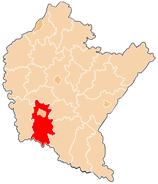
Jasło County is a unit of territorial administration and local government (powiat) in Subcarpathian Voivodeship, south-eastern Poland, on the Slovak border. It came into being on January 1, 1999, as a result of the Polish local government reforms passed in 1998. Its administrative seat is Jasło, which lies 50 kilometres (31 mi) south-west of the regional capital Rzeszów. The only other town in the county is Kołaczyce, which is 8 km (5.0 mi) north of Jasło.

Sanok County is a unit of territorial administration and local government (powiat) in Subcarpathian Voivodeship, south-eastern Poland, on the Slovak border. It came into being on January 1, 1999, as a result of the Polish local government reforms passed in 1998. Its administrative seat and largest town is Sanok, which lies 56 kilometres (35 mi) south of the regional capital Rzeszów. The only other town in the county is Zagórz, lying 6 km (4 mi) south-east of Sanok.

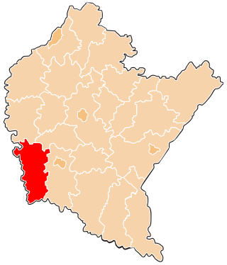
Przemyśl County is a unit of territorial administration and local government (powiat) in Subcarpathian Voivodeship, south-eastern Poland, on the border with Ukraine. It came into being on January 1, 1999, as a result of the Polish local government reforms passed in 1998. Its administrative seat is the city of Przemyśl, although the city is not part of the county.
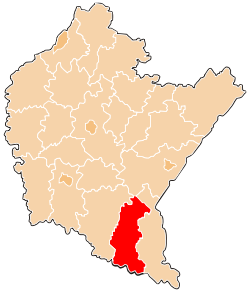
Krosno County is a unit of territorial administration and local government (powiat) in Subcarpathian Voivodeship, south-eastern Poland, on the Slovak border. It came into being on January 1, 1999, as a result of the Polish local government reforms passed in 1998. Its administrative seat is the city of Krosno, although the city is not part of the county. The county contains four towns: Jedlicze, Rymanów, Dukla, and Iwonicz-Zdrój.

Wyszków County is a unit of territorial administration and local government (powiat) in Masovian Voivodeship, east-central Poland. It originally existed from 1956 until the abolition of the powiats in 1975, but was re-created on January 1, 1999, as a result of the Polish local government reforms passed in 1998, which reintroduced the powiats and created 16 large voivodeships. The administrative seat and only town in the county is Wyszków, which lies 53 kilometres (33 mi) north-east of Warsaw.

Otwock County is a unit of territorial administration and local government (powiat) in Masovian Voivodeship, east-central Poland. It came into being on January 1, 1999, as a result of the Polish local government reforms passed in 1998. Its administrative seat and largest town is Otwock, which lies 22 kilometres (14 mi) south-east of Warsaw. The county also contains the towns of Józefów, lying 3 km (2 mi) north-west of Otwock, and Karczew, 4 km (2 mi) south of Otwock.

Szydłowiec County is a unit of territorial administration and local government (powiat) in Masovian Voivodeship, east-central Poland. It came into being on January 1, 1999, as a result of the Polish local government reforms passed in 1998. Its administrative seat and only town is Szydłowiec, which lies 110 kilometres (68 mi) south of Warsaw.

Włoszczowa County is a unit of territorial administration and local government (powiat) in Świętokrzyskie Voivodeship, south-central Poland. It came into being on January 1, 1999, as a result of the Polish local government reforms passed in 1998. Its administrative seat and only town is Włoszczowa, which lies 46 kilometres (29 mi) west of the regional capital Kielce.

Gołdap County is a unit of territorial administration and local government (powiat) in Warmian-Masurian Voivodeship, northern Poland, on the border with Russia. Its administrative seat and only town is Gołdap, which lies 133 kilometres (83 mi) north-east of the regional capital Olsztyn.
Namysłów County is a unit of territorial administration and local government (powiat) in Opole Voivodeship, south-western Poland. It came into being on January 1, 1999, as a result of the Polish local government reforms passed in 1998. Its administrative seat and only town is Namysłów, which lies 48 kilometres (30 mi) north of the regional capital, which is the city of Opole.

Gorlice County is a unit of territorial administration and local government (powiat) in Lesser Poland Voivodeship, southern Poland, on the Slovak border. It was created on 1 January 1999 as a result of the Polish local government reforms passed in 1998. Its administrative seat and largest town is Gorlice, which lies 100 kilometres (62 mi) south-east of the regional capital Kraków. The only other towns in the county are Biecz, lying 12 km (7 mi) north-east of Gorlice, and Bobowa, 18 km (11 mi) west of Gorlice.

Nowy Targ County is a unit of territorial administration and local government (powiat) in Lesser Poland Voivodeship, southern Poland, on the Slovak border. It came into being on January 1, 1999, as a result of the Polish local government reforms passed in 1998. Its administrative seat and largest town is Nowy Targ, which lies 67 kilometres (42 mi) south of the regional capital Kraków. The county also contains the towns of Rabka-Zdrój, lying 18 km (11 mi) north of Nowy Targ, and Szczawnica, 35 km (22 mi) east of Nowy Targ.

Tatra County is a unit of territorial administration and local government (powiat) in Lesser Poland Voivodeship, southern Poland, on the Slovak border. It came into being on January 1, 1999, as a result of the Polish local government reforms passed in 1998. Its administrative seat and only town is Zakopane, which lies 85 kilometres (53 mi) south of the regional capital Kraków. The county takes its name from the Tatra mountain range, which covers most of its territory.

Racibórz County is a unit of territorial administration and local government (powiat) in Silesian Voivodeship, southern Poland, on the Czech border. It came into being on January 1, 1999, as a result of the Polish local government reforms passed in 1998. Its administrative seat and largest town is Racibórz, which lies 58 kilometres (36 mi) west of the regional capital Katowice. The county also contains the towns of Kuźnia Raciborska, lying 16 km (10 mi) north of Racibórz, and Krzanowice, 11 km (7 mi) south-west of Racibórz.

Żywiec County is a unit of territorial administration and local government (powiat) in Silesian Voivodeship, southern Poland, on the Slovak border. It came into being on January 1, 1999, as a result of the Polish local government reforms passed in 1998. Its administrative seat and only town is Żywiec, which lies 64 kilometres (40 mi) south of the regional capital Katowice.