Gmina Solina

Last updated
Gmina Solina
Solina Commune
Gmina
POL gmina Solina COA.svg
Coat of arms
Coordinates(Solina): 49°23′N22°28′E / 49.383°N 22.467°E / 49.383; 22.467 Coordinates: 49°23′N22°28′E / 49.383°N 22.467°E / 49.383; 22.467
CountryFlag of Poland.svg  Poland
Voivodeship Subcarpathian
County Lesko
Seat Polańczyk
Area
  Total 184.25 km2 (71.14 sq mi)
Population (2006)
  Total 5,106
  Density 28/km2 (72/sq mi)
Website http://www.esolina.pl

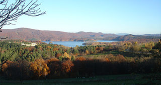
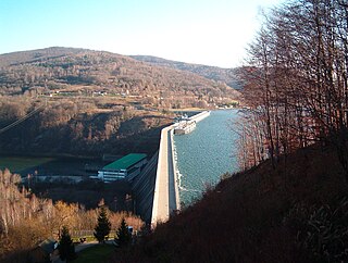
Gmina Solina is a rural gmina (administrative district) in Lesko County, Subcarpathian Voivodeship, in south-eastern Poland. It takes its name from its former seat, the village of Solina, which lies approximately 15 kilometres (9 mi) south-east of Lesko and 80 km (50 mi) south-east of the regional capital Rzeszów. The present seat is Polańczyk.

Gmina administrative division of Poland

The gmina is the principal unit of the administrative division of Poland, similar to a municipality. As of 2010 there were 2,478 gminy throughout the country. The word gmina derives from the German word Gemeinde, meaning "community".

Lesko County County in Subcarpathian, Poland

Lesko County is a unit of territorial administration and local government (powiat) in Subcarpathian Voivodeship, south-eastern Poland, on the Slovak border. It was created in 2002 out of five gminas which previously made up the western part of Bieszczady County. Its administrative seat and only town is Lesko, which lies 67 kilometres (42 mi) south of the regional capital Rzeszów.

Poland Republic in Central Europe

Poland, officially the Republic of Poland, is a country located in Central Europe. It is divided into 16 administrative subdivisions, covering an area of 312,696 square kilometres (120,733 sq mi), and has a largely temperate seasonal climate. With a population of approximately 38.5 million people, Poland is the sixth most populous member state of the European Union. Poland's capital and largest metropolis is Warsaw. Other major cities include Kraków, Łódź, Wrocław, Poznań, Gdańsk, and Szczecin.

Contents

The gmina covers an area of 184.25 square kilometres (71.1 sq mi), and as of 2006 its total population is 5,106.

The gmina contains parts of the protected areas called Cisna-Wetlina Landscape Park and San Valley Landscape Park.

Protected area location which receives protection because of its recognised natural, ecological or cultural landscape values

Protected areas or conservation areas are locations which receive protection because of their recognized natural, ecological or cultural values. There are several kinds of protected areas, which vary by level of protection depending on the enabling laws of each country or the regulations of the international organizations involved.

Cisna-Wetlina Landscape Park is a protected area in south-eastern Poland, established in 1992, covering an area of 510.14 square kilometres (196.97 sq mi).

San Valley Landscape Park is a protected area in south-eastern Poland, established in 1992, covering an area of 342.70 square kilometres (132.32 sq mi).

Villages

Gmina Solina contains the villages and settlements of Berezka, Bereźnica Wyżna, Bóbrka, Bukowiec, Górzanka, Jawor, Myczków, Myczkowce, Polańczyk, Rajskie, Rybne, Solina, Terka, Werlas, Wola Matiaszowa, Wołkowyja and Zawóz.

Berezka Village in Subcarpathian, Poland

Berezka is a village in the administrative district of Gmina Solina, within Lesko County, Subcarpathian Voivodeship, in south-eastern Poland. It lies approximately 23 kilometres (14 mi) north of Solina, 14 km (9 mi) north-east of Lesko, and 58 km (36 mi) south-east of the regional capital Rzeszów.

Bereźnica Wyżna Village in Subcarpathian, Poland

Bereźnica Wyżna is a village in the administrative district of Gmina Solina, within Lesko County, Subcarpathian Voivodeship, in south-eastern Poland. It lies approximately 9 kilometres (6 mi) south-west of Solina, 14 km (9 mi) south of Lesko, and 80 km (50 mi) south of the regional capital Rzeszów.

Bóbrka, Lesko County Village in Subcarpathian, Poland

Bóbrka is a village in the administrative district of Gmina Solina, within Lesko County, Subcarpathian Voivodeship, in south-eastern Poland. It lies approximately 4 kilometres (2 mi) north of Solina, 11 km (7 mi) south-east of Lesko, and 76 km (47 mi) south-east of the regional capital Rzeszów.

Neighbouring gminas

Gmina Solina is bordered by the gminas of Baligród, Cisna, Czarna, Lesko, Olszanica and Ustrzyki Dolne.

Gmina Baligród is a rural gmina in Lesko County, Subcarpathian Voivodeship, in south-eastern Poland. Its seat is the village of Baligród, which lies approximately 15 kilometres (9 mi) south of Lesko and 79 km (49 mi) south of the regional capital Rzeszów.

Gmina Cisna is a rural gmina in Lesko County, Subcarpathian Voivodeship, in south-eastern Poland, on the Slovak border. Its seat is the village of Cisna, which lies approximately 30 kilometres (19 mi) south of Lesko and 95 km (59 mi) south of the regional capital Rzeszów.

Gmina Czarna is a rural gmina in Bieszczady County, Subcarpathian Voivodeship, in south-eastern Poland, on the border with Ukraine. Its seat is the village of Czarna, which lies approximately 14 kilometres (9 mi) south of Ustrzyki Dolne and 93 km (58 mi) south-east of the regional capital Rzeszów.

Related Research Articles

Podkarpackie Voivodeship Voivodeship in Poland

Podkarpackie Voivodeship or Podkarpackie Province, also known as Subcarpathian Voivodeship or Subcarpathia Province, is a voivodeship, or province, in extreme-southeastern Poland. Its administrative capital and largest city is Rzeszów..

Polańczyk Village in Subcarpathian, Poland

Polańczyk is a village in Lesko County, Subcarpathian Voivodeship, in south-eastern Poland. It lies in, and serves as the seat of, the administrative district of Gmina Solina. Polańczyk lies approximately 4 kilometres (2 mi) south-west of Solina, 14 km (9 mi) south-east of Lesko, and 80 km (50 mi) south of the regional capital Rzeszów. In 2002 the village had a population of 830.

Gmina Ustrzyki Dolne is an urban-rural gmina in Bieszczady County, Subcarpathian Voivodeship, in south-eastern Poland. Its seat is the town of Ustrzyki Dolne, which lies approximately 80 kilometres (50 mi) south-east of the regional capital Rzeszów.

Gmina Lutowiska is a rural gmina in Bieszczady County, Subcarpathian Voivodeship, in south-eastern Poland, on the border with Ukraine. Its seat is the village of Lutowiska, which lies approximately 22 kilometres (14 mi) south of Ustrzyki Dolne and 101 km (63 mi) south-east of the regional capital Rzeszów.

Gmina Lesko is an urban-rural gmina in Lesko County, Subcarpathian Voivodeship, in south-eastern Poland. Its seat is the town of Lesko, which lies approximately 67 kilometres (42 mi) south of the regional capital Rzeszów.

Gmina Olszanica is a rural gmina in Lesko County, Subcarpathian Voivodeship, in south-eastern Poland. Its seat is the village of Olszanica, which lies approximately 9 kilometres (6 mi) east of Lesko and 71 km (44 mi) south-east of the regional capital Rzeszów.

Gmina Komańcza is a rural gmina in Sanok County, Subcarpathian Voivodeship, in south-eastern Poland, on the Slovak border. Its seat is the village of Komańcza, which lies approximately 25 kilometres (16 mi) south-west of Sanok and 76 km (47 mi) south of the regional capital Rzeszów.

Gmina Sanok is a rural gmina in Sanok County, Subcarpathian Voivodeship, in south-eastern Poland. Its seat is the town of Sanok, although the town is not part of the territory of the gmina.

Gmina Tyrawa Wołoska is a rural gmina in Sanok County, Subcarpathian Voivodeship, in south-eastern Poland. Its seat is the village of Tyrawa Wołoska, which lies approximately 12 kilometres (7 mi) east of Sanok and 57 km (35 mi) south-east of the regional capital Rzeszów.

Gmina Zagórz is an urban-rural gmina in Sanok County, Subcarpathian Voivodeship, in south-eastern Poland. Its seat is the town of Zagórz, which lies approximately 6 kilometres (4 mi) south-east of Sanok and 61 km (38 mi) south of the regional capital Rzeszów.

Solina, Poland Village in Subcarpathian, Poland

Solina is a village in Lesko County, Subcarpathian Voivodeship, in south-eastern Poland. It is the former seat of the gmina called Gmina Solina. It lies approximately 15 kilometres (9 mi) south-east of Lesko and 80 km (50 mi) south-east of the regional capital Rzeszów. In 2002 the village had a population of 190.

Buk, Podkarpackie Voivodeship Village in Subcarpathian, Poland

Buk is a village in the administrative district of Gmina Cisna, within Lesko County, Subcarpathian Voivodeship, in south-eastern Poland, close to the border with Slovakia. It lies approximately 6 kilometres (4 mi) north-east of Cisna, 26 km (16 mi) south of Lesko, and 92 km (57 mi) south of the regional capital Rzeszów.

Dołżyca, Lesko County Village in Subcarpathian, Poland

Dołżyca is a village in the administrative district of Gmina Cisna, within Lesko County, Subcarpathian Voivodeship, in south-eastern Poland, close to the border with Slovakia. It lies approximately 2 kilometres (1 mi) north-east of Cisna, 29 km (18 mi) south of Lesko, and 94 km (58 mi) south of the regional capital Rzeszów.

Kalnica, Lesko County Village in Subcarpathian, Poland

Kalnica is a village in the administrative district of Gmina Cisna, within Lesko County, Subcarpathian Voivodeship, in south-eastern Poland, close to the border with Slovakia. It lies approximately 8 kilometres (5 mi) east of Cisna, 33 km (21 mi) south of Lesko, and 99 km (62 mi) south of the regional capital Rzeszów.

Krzywe, Lesko County Village in Subcarpathian, Poland

Krzywe is a village in the administrative district of Gmina Cisna, within Lesko County, Subcarpathian Voivodeship, in south-eastern Poland, close to the border with Slovakia. It lies approximately 4 kilometres (2 mi) south-east of Cisna, 32 km (20 mi) south of Lesko, and 97 km (60 mi) south of the regional capital Rzeszów.

Smerek, Podkarpackie Voivodeship Village in Subcarpathian, Poland

Smerek is a village in the administrative district of Gmina Cisna, within Lesko County, Subcarpathian Voivodeship, in south-eastern Poland, close to the border with Slovakia. It lies approximately 9 kilometres (6 mi) south-east of Cisna, 34 km (21 mi) south of Lesko, and 100 km (62 mi) south of the regional capital Rzeszów.

References