
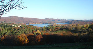
Lake Solina is an artificial lake in the Bieszczady Mountains region, more precisely in Lesko County of the Subcarpathian Voivodship of Poland. Its coordinates are 49°22′27″N22°27′8″E.
Polańczyk is a village in Lesko County, Subcarpathian Voivodeship, in south-eastern Poland. It lies in, and serves as the seat of, the administrative district of Gmina Solina. Polańczyk lies approximately 4 kilometres (2 mi) south-west of Solina, 14 km (9 mi) south-east of Lesko, and 80 km (50 mi) south of the regional capital Rzeszów. In 2002 the village had a population of 830.
Gmina Baligród is a rural gmina in Lesko County, Subcarpathian Voivodeship, in south-eastern Poland. Its seat is the village of Baligród, which lies approximately 15 kilometres (9 mi) south of Lesko and 79 km (49 mi) south of the regional capital Rzeszów.

Berezka is a village in the administrative district of Gmina Solina, within Lesko County, Subcarpathian Voivodeship, in south-eastern Poland. It lies approximately 23 kilometres (14 mi) north of Solina, 14 km (9 mi) north-east of Lesko, and 58 km (36 mi) south-east of the regional capital Rzeszów.
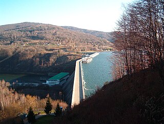
Solina is a village in Lesko County, Subcarpathian Voivodeship, in south-eastern Poland. It is the former seat of the gmina called Gmina Solina. It lies approximately 15 kilometres (9 mi) south-east of Lesko and 80 km (50 mi) south-east of the regional capital Rzeszów. In 2002 the village had a population of 190.
Łukawica is a village in the administrative district of Gmina Lesko, within Lesko County, Subcarpathian Voivodeship, in south-eastern Poland. It lies approximately 3 kilometres (2 mi) north of Lesko and 64 km (40 mi) south of the regional capital Rzeszów.
Weremień is a village in the administrative district of Gmina Lesko, within Lesko County, Subcarpathian Voivodeship, in south-eastern Poland. It lies approximately 3 kilometres (2 mi) south of Lesko and 69 km (43 mi) south of the regional capital Rzeszów.
Rabe is a village in the administrative district of Gmina Baligród, within Lesko County, Subcarpathian Voivodeship, in south-eastern Poland. It lies approximately 4 kilometres (2 mi) south-west of Baligród, 18 km (11 mi) south of Lesko, and 82 km (51 mi) south of the regional capital Rzeszów.
Stężnica is a village in the administrative district of Gmina Baligród, within Lesko County, Subcarpathian Voivodeship, in south-eastern Poland. It lies approximately 5 kilometres (3 mi) south-east of Baligród, 16 km (10 mi) south of Lesko, and 82 km (51 mi) south of the regional capital Rzeszów.
Bukowiec is a village in the administrative district of Gmina Solina, within Lesko County, Subcarpathian Voivodeship, in south-eastern Poland. It lies approximately 10 kilometres (6 mi) south-west of Solina, 20 km (12 mi) south of Lesko, and 86 km (53 mi) south of the regional capital Rzeszów.
Górzanka is a village in the administrative district of Gmina Solina, within Lesko County, Subcarpathian Voivodeship, in south-eastern Poland. It lies approximately 9 kilometres (6 mi) south-west of Solina, 17 km (11 mi) south of Lesko, and 83 km (52 mi) south of the regional capital Rzeszów.

Jawor is a village in the administrative district of Gmina Solina, within Lesko County, Subcarpathian Voivodeship, in south-eastern Poland. It lies approximately 2 kilometres (1 mi) north-west of Solina, 14 km (9 mi) south-east of Lesko, and 79 km (49 mi) south-east of the regional capital Rzeszów.
Myczków is a village in the administrative district of Gmina Solina, within Lesko County, Subcarpathian Voivodeship, in south-eastern Poland. It lies approximately 5 kilometres (3 mi) west of Solina, 13 km (8 mi) south-east of Lesko, and 79 km (49 mi) south of the regional capital Rzeszów.
Rajskie is a village in the administrative district of Gmina Solina, within Lesko County, Subcarpathian Voivodeship, in south-eastern Poland. It lies approximately 8 kilometres (5 mi) south of Solina, 21 km (13 mi) south-east of Lesko, and 87 km (54 mi) south-east of the regional capital Rzeszów.
Rybne is a village in the administrative district of Gmina Solina, within Lesko County, Subcarpathian Voivodeship, in south-eastern Poland. It lies approximately 7 km southwest of Solina, 16 km (10 mi) south of Lesko, and 82 km (51 mi) south of the regional capital Rzeszów.
Terka is a village in the administrative district of Gmina Solina, within Lesko County, Subcarpathian Voivodeship, in south-eastern Poland. It lies approximately 10 kilometres (6 mi) south of Solina, 21 km (13 mi) south of Lesko, and 88 km (55 mi) south of the regional capital Rzeszów.
Werlas is a village in the administrative district of Gmina Solina, within Lesko County, Subcarpathian Voivodeship, in south-eastern Poland. It lies approximately 5 kilometres (3 mi) to the south of Solina, 18 km (11 mi) south-east of Lesko, and 84 km (52 mi) south-east of the regional capital Rzeszów.
Wola Matiaszowa is a village in the administrative district of Gmina Solina, within Lesko County, Subcarpathian Voivodeship, in south-eastern Poland. It lies approximately 7 kilometres (4 mi) west of Solina, 11 km (7 mi) south of Lesko, and 78 km (48 mi) south of the regional capital Rzeszów.
Zawóz is a village in the administrative district of Gmina Solina, within Lesko County, Subcarpathian Voivodeship, in south-eastern Poland. It lies approximately 4 kilometres (2 mi) south of Solina, 17 km (11 mi) south-east of Lesko, and 83 km (52 mi) south-east of the regional capital Rzeszów.


