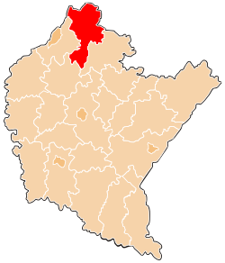
Kolbuszowa County is a unit of territorial administration and local government (powiat) in Subcarpathian Voivodeship, south-eastern Poland. It came into being on January 1, 1999, as a result of the Polish local government reforms passed in 1998. Its administrative seat and only town is Kolbuszowa, which lies 30 kilometres (19 mi) north-west of the regional capital Rzeszów.

Nisko County is a unit of territorial administration and local government (powiat) in Subcarpathian Voivodeship, south-eastern Poland. It came into being on January 1, 1999, as a result of the Polish local government reforms passed in 1998. Its administrative seat and largest town is Nisko, which lies 57 kilometres (35 mi) north of the regional capital Rzeszów. The county also contains the towns of Rudnik nad Sanem, lying 13 km (8 mi) south-east of Nisko, and Ulanów, 11 km (7 mi) east of Nisko.

Tarnobrzeg County is a unit of territorial administration and local government (powiat) in Subcarpathian Voivodeship, south-eastern Poland. It came into being on January 1, 1999, as a result of the Polish local government reforms passed in 1998. Its administrative seat is the city of Tarnobrzeg, although the city is not part of the county. The only towns in Tarnobrzeg County are Nowa Dęba, which lies 18 km (11 mi) south of Tarnobrzeg, and Baranów Sandomierski, 15 km (9 mi) south-west of Tarnobrzeg.

Wyszków County is a unit of territorial administration and local government (powiat) in Masovian Voivodeship, east-central Poland. It originally existed from 1956 until the abolition of the powiats in 1975, but was re-created on January 1, 1999, as a result of the Polish local government reforms passed in 1998, which reintroduced the powiats and created 16 large voivodeships. The administrative seat and only town in the county is Wyszków, which lies 53 kilometres (33 mi) north-east of Warsaw.

Kraśnik County is a unit of territorial administration and local government (powiat) in Lublin Voivodeship, eastern Poland. It was established on January 1, 1999, as a result of the Polish local government reforms passed in 1998. Its administrative seat and largest town is Kraśnik, which lies 45 kilometres (28 mi) south-west of the regional capital Lublin. The only other town in the county is Annopol, lying 25 km (16 mi) west of Kraśnik.

Janów County is a unit of territorial administration and local government (powiat) in Lublin Voivodeship, eastern Poland. It was established on January 1, 1999, as a result of the Polish local government reforms passed in 1998. Its administrative seat and only town is Janów Lubelski, which lies 60 kilometres (37 mi) south of the regional capital Lublin.

Tomaszów County is a unit of territorial administration and local government (powiat) in Lublin Voivodeship, eastern Poland, on the border with Ukraine. It was established on January 1, 1999, as a result of the Polish local government reforms passed in 1998. Its administrative seat and largest town is Tomaszów Lubelski, which lies 107 kilometres (66 mi) south-east of the regional capital Lublin. The only other towns in the county are Tyszowce, lying 28 km (17 mi) north-east of Tomaszów, and Łaszczów, lying 25 km (16 mi) east of Tomaszów.

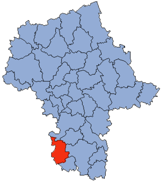
Garwolin County is a unit of territorial administration and local government (powiat) in Masovian Voivodeship, east-central Poland. It came into being on 1 January 1999, as a result of the Polish local government reforms passed in 1998. Its administrative seat and largest town is Garwolin, which lies 56 kilometres (35 mi) south-east of Warsaw. The county contains three other towns: Łaskarzew, 13 km (8 mi) south of Garwolin, Pilawa, 10 km (6 mi) north-west of Garwolin, and Żelechów, 22 km (14 mi) south-east of Garwolin.

Maków County is a unit of territorial administration and local government (powiat) in Masovian Voivodeship, east-central Poland. It came into being on January 1, 1999, as a result of the Polish local government reforms passed in 1998. Its administrative seat and largest town is Maków Mazowiecki, which lies 73 kilometres (45 mi) north of Warsaw. The only other town in the county is Różan, lying 20 km (12 mi) east of Maków Mazowiecki.
Przysucha County is a unit of territorial administration and local government (powiat) in Masovian Voivodeship, east-central Poland. It came into being on January 1, 1999, as a result of the Polish local government reforms passed in 1998. Its administrative seat and only town is Przysucha, which lies 98 kilometres (61 mi) south of Warsaw.
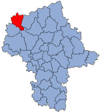
Żuromin County is a unit of territorial administration and local government (powiat) in Masovian Voivodeship, east-central Poland. It came into being on January 1, 1999, as a result of the Polish local government reforms passed in 1998. Its administrative seat and largest town is Żuromin, which lies 121 kilometres (75 mi) north-west of Warsaw. Other towns in the county are Bieżuń, lying 13 km (8 mi) south of Żuromin and Lubowidz, lying 9 km (6 mi) north-west of Żuromin.
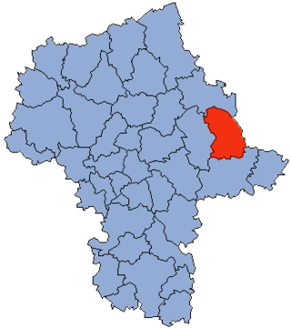
Sokołów County is a powiat in Masovian Voivodeship, east-central Poland. It came into being on January 1, 1999, as a result of the Polish local government reforms passed in 1998. Its administrative seat and largest town is Sokołów Podlaski, which lies 88 kilometres (55 mi) east of Warsaw. The only other town in the county is Kosów Lacki, lying 23 km (14 mi) north of Sokołów Podlaski.
Sandomierz County is a unit of territorial administration and local government (powiat) in Świętokrzyskie Voivodeship, south-central Poland. It came into being on January 1, 1999, as a result of the Polish local government reforms passed in 1998. Its administrative seat and largest town is Sandomierz, which lies 83 kilometres (52 mi) east of the regional capital Kielce. The county also contains the towns of Koprzywnica, lying 16 km (10 mi) south-west of Sandomierz, and Zawichost, 16 km (10 mi) north-east of Sandomierz.

Opatów County is a unit of territorial administration and local government (powiat) in Świętokrzyskie Voivodeship, south-central Poland. It came into being on January 1, 1999, as a result of the Polish local government reforms passed in 1998. Its administrative seat and largest town is Opatów, which lies 58 kilometres (36 mi) east of the regional capital Kielce. The only other town in the county is Ożarów, lying 20 km (12 mi) north-east of Opatów.
Końskie County is a unit of territorial administration and local government (powiat) in Świętokrzyskie Voivodeship, central Poland. It came into being on January 1, 1999, as a result of the Polish local government reforms passed in 1998. Its administrative seat and largest town is Końskie, which lies 38 kilometres (24 mi) north of the regional capital Kielce. The only other town in the county is Stąporków, lying 11 km (7 mi) south-east of Końskie.
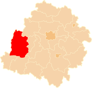
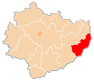
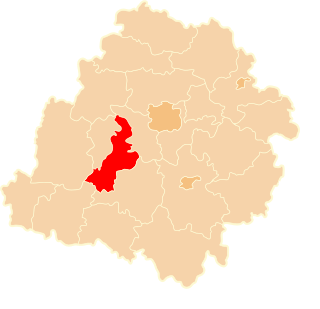
Sieradz County is a unit of territorial administration and local government (powiat) in Łódź Voivodeship, central Poland. It came into being on January 1, 1999, as a result of the Polish local government reforms passed in 1998. Its administrative seat and largest town is Sieradz, which lies 54 kilometres (34 mi) west of the regional capital Łódź. The county contains three other towns: Złoczew, lying 23 km (14 mi) south-west of Sieradz, Warta, lying 14 km (9 mi) north-west of Sieradz, and Błaszki, 23 km (14 mi) west of Sieradz.
Zduńska Wola County is a unit of territorial administration and local government (powiat) in Łódź Voivodeship, central Poland. It came into being on January 1, 1999, as a result of the Polish local government reforms passed in 1998. Its administrative seat and largest town is Zduńska Wola, which lies 41 kilometres (25 mi) south-west of the regional capital Łódź. The only other town in the county is Szadek, lying 12 km (7 mi) north of Zduńska Wola.
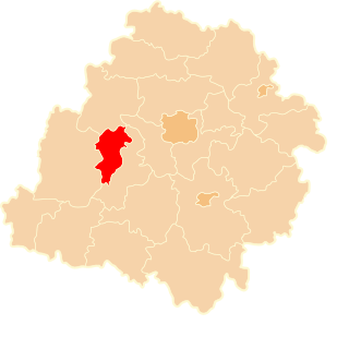
Łask County is a unit of territorial administration and local government (powiat) in Łódź Voivodeship, central Poland. It came into being on January 1, 1999, as a result of the Polish local government reforms passed in 1998. Its administrative seat and only town is Łask, which lies 32 kilometres (20 mi) south-west of the regional capital Łódź.

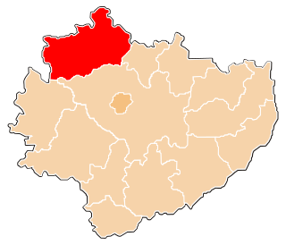
Poddębice County is a unit of territorial administration and local government (powiat) in Łódź Voivodeship, central Poland. It came into being on January 1, 1999, as a result of the Polish local government reforms passed in 1998. Its administrative seat and largest town is Poddębice, which lies 37 kilometres (23 mi) west of the regional capital Łódź. The only other town in the county is Uniejów, lying 14 km (9 mi) north-west of Poddębice.

Gołdap County is a unit of territorial administration and local government (powiat) in Warmian-Masurian Voivodeship, northern Poland, on the border with Russia. Its administrative seat and only town is Gołdap, which lies 133 kilometres (83 mi) north-east of the regional capital Olsztyn.