Wyszków County is a unit of territorial administration and local government (powiat) in Masovian Voivodeship, east-central Poland. It originally existed from 1956 until the abolition of the powiats in 1975, but was re-created on January 1, 1999, as a result of the Polish local government reforms passed in 1998, which reintroduced the powiats and created 16 large voivodeships. The administrative seat and only town in the county is Wyszków, which lies 53 kilometres (33 mi) north-east of Warsaw.

Grójec County is a unit of territorial administration and local government (powiat) in Masovian Voivodeship, east-central Poland. It came into being on January 1, 1999, as a result of the Polish local government reforms passed in 1998. Its administrative seat and largest town is Grójec, which lies 40 kilometres (25 mi) south of Warsaw. The county contains three other towns: Warka, 25 km (16 mi) east of Grójec, Nowe Miasto nad Pilicą, 34 km (21 mi) south-west of Grójec, and Mogielnica, 22 km (14 mi) south-west of Grójec.

Radom County is a unit of territorial administration and local government (powiat) in Masovian Voivodeship, east-central Poland. It came into being on January 1, 1999, as a result of the Polish local government reforms passed in 1998. Its administrative seat is the city of Radom, although the city is not part of the county. The county contains three towns: Pionki, 22 km (14 mi) north-east of Radom, Iłża, 27 km (17 mi) south of Radom, and Skaryszew, 12 km (7 mi) south-east of Radom.

Opole County is a unit of territorial administration and local government (powiat) in Lublin Voivodeship, eastern Poland. It was established on January 1, 1999, as a result of the Polish local government reforms passed in 1998. Its administrative seat is the town of Opole Lubelskie, which lies 44 kilometres (27 mi) west of the regional capital Lublin. The only other town in the county is Poniatowa, lying 8 km (5 mi) north-east of Opole Lubelskie.

Tomaszów County is a unit of territorial administration and local government (powiat) in Lublin Voivodeship, eastern Poland, on the border with Ukraine. It was established on January 1, 1999, as a result of the Polish local government reforms passed in 1998. Its administrative seat and largest town is Tomaszów Lubelski, which lies 107 kilometres (66 mi) south-east of the regional capital Lublin. The only other towns in the county are Tyszowce, lying 28 km (17 mi) north-east of Tomaszów, and Łaszczów, lying 25 km (16 mi) east of Tomaszów.
Grajewo County is a unit of territorial administration and local government (powiat) in Podlaskie Voivodeship, north-eastern Poland. It came into being on January 1, 1999, as a result of the Polish local government reforms passed in 1998. Its administrative seat and largest town is Grajewo, which lies 76 kilometres (47 mi) north-west of the regional capital Białystok. The county also contains the towns of Szczuczyn, lying 15 km (9 mi) south-west of Grajewo, and Rajgród, 19 km (12 mi) north-east of Grajewo.

Garwolin County is a unit of territorial administration and local government (powiat) in Masovian Voivodeship, east-central Poland. It came into being on 1 January 1999, as a result of the Polish local government reforms passed in 1998. Its administrative seat and largest town is Garwolin, which lies 56 kilometres (35 mi) south-east of Warsaw. The county contains three other towns: Łaskarzew, 13 km (8 mi) south of Garwolin, Pilawa, 10 km (6 mi) north-west of Garwolin, and Żelechów, 22 km (14 mi) south-east of Garwolin.

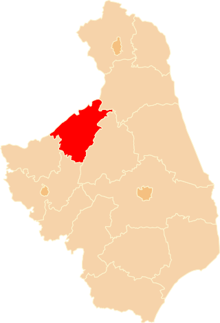
Maków County is a unit of territorial administration and local government (powiat) in Masovian Voivodeship, east-central Poland. It came into being on January 1, 1999, as a result of the Polish local government reforms passed in 1998. Its administrative seat and largest town is Maków Mazowiecki, which lies 73 kilometres (45 mi) north of Warsaw. The only other town in the county is Różan, lying 20 km (12 mi) east of Maków Mazowiecki.

Sochaczew County is a unit of territorial administration and local government (powiat) in Masovian Voivodeship, east-central Poland. It came into being on January 1, 1999, as a result of the Polish local government reforms passed in 1998. Its administrative seat and only town is Sochaczew, which lies 52 kilometres (32 mi) west of Warsaw.

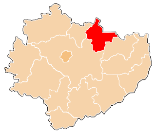
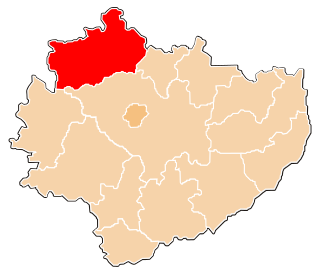
Przasnysz County is a unit of territorial administration and local government (powiat) in Masovian Voivodeship, east-central Poland. It came into being on 1 January 1999, as a result of the Polish local government reforms passed in 1998. Its administrative seat and largest town is Przasnysz, which lies 90 kilometres (56 mi) north of Warsaw. The only other town in the county is Chorzele, lying 26 km (16 mi) north of Przasnysz. The county covers an area of 1,217.82 square kilometres (470.2 sq mi). As of 2019, its total population is 52,616, out of which the population of Przasnysz is 17,264, that of Chorzele is 3,088, and the rural population is 32,324.
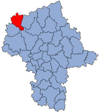
Żuromin County is a unit of territorial administration and local government (powiat) in Masovian Voivodeship, east-central Poland. It came into being on January 1, 1999, as a result of the Polish local government reforms passed in 1998. Its administrative seat and largest town is Żuromin, which lies 121 kilometres (75 mi) north-west of Warsaw. Other towns in the county are Bieżuń, lying 13 km (8 mi) south of Żuromin and Lubowidz, lying 9 km (6 mi) north-west of Żuromin.

Zwoleń County is a unit of territorial administration and local government (powiat) in Masovian Voivodeship, east-central Poland. It came into being on January 1, 1999, as a result of the Polish local government reforms passed in 1998. Its administrative seat and only town is Zwoleń, which lies 104 kilometres (65 mi) south-east of Warsaw.

Płońsk County is a unit of territorial administration and local government (powiat) in Masovian Voivodeship, east-central Poland. It came into being on 1 January 1999, as a result of the Polish local government reforms passed in 1998. Its administrative seat and largest town is Płońsk, which lies 63 kilometres (39 mi) north-west of Warsaw. The only other town in the county is Raciąż, lying 25 km (16 mi) north-west of Płońsk.
Starachowice County is a unit of territorial administration and local government (powiat) in Świętokrzyskie Voivodeship, south-central Poland. It came into being on January 1, 1999, as a result of the Polish local government reforms passed in 1998. Its administrative seat and largest town is Starachowice, which lies 37 kilometres (23 mi) north-east of the regional capital Kielce. The only other town in the county is Wąchock, lying 5 km (3 mi) north-west of Starachowice.

Jędrzejów County is a unit of territorial administration and local government (powiat) in Świętokrzyskie Voivodeship, south-central Poland. It came into being on January 1, 1999, as a result of the Polish local government reforms passed in 1998. Its administrative seat and largest town is Jędrzejów, which lies 36 kilometres (22 mi) south-west of the regional capital Kielce. The county also contains the towns of Sędziszów, lying 18 km (11 mi) west of Jędrzejów, and Małogoszcz, 21 km (13 mi) north of Jędrzejów.

Opatów County is a unit of territorial administration and local government (powiat) in Świętokrzyskie Voivodeship, south-central Poland. It came into being on January 1, 1999, as a result of the Polish local government reforms passed in 1998. Its administrative seat and largest town is Opatów, which lies 58 kilometres (36 mi) east of the regional capital Kielce. The only other town in the county is Ożarów, lying 20 km (12 mi) north-east of Opatów.
Końskie County is a unit of territorial administration and local government (powiat) in Świętokrzyskie Voivodeship, central Poland. It came into being on January 1, 1999, as a result of the Polish local government reforms passed in 1998. Its administrative seat and largest town is Końskie, which lies 38 kilometres (24 mi) north of the regional capital Kielce. The only other town in the county is Stąporków, lying 11 km (7 mi) south-east of Końskie.
Ostrowiec County is a unit of territorial administration and local government (powiat) in Świętokrzyskie Voivodeship, south-central Poland. It came into being on January 1, 1999, as a result of the Polish local government reforms passed in 1998. Its administrative seat and largest town is Ostrowiec Świętokrzyski, which lies 56 kilometres (35 mi) east of the regional capital Kielce. The county also contains the towns of Ćmielów, lying 10 km (6 mi) south-east of Ostrowiec Świętokrzyski, and Kunów, 9 km (6 mi) west of Ostrowiec Świętokrzyski.

Gołdap County is a unit of territorial administration and local government (powiat) in Warmian-Masurian Voivodeship, northern Poland, on the border with Russia. Its administrative seat and only town is Gołdap, which lies 133 kilometres (83 mi) north-east of the regional capital Olsztyn.

Opole County is a unit of territorial administration and local government (powiat) in Opole Voivodeship, south-western Poland. It came into being on January 1, 1999, as a result of the Polish local government reforms passed in 1998. Its administrative seat is the city of Opole, although the city is not part of the county. The county contains four towns: Ozimek, 20 km (12 mi) east of Opole, Niemodlin, 24 km (15 mi) west of Opole, Prószków, 11 km (7 mi) south-west of Opole, and Tułowice, 22 kilometres (14 mi) south-west of Opole.